
Geomorphology and Geology Studies Using Digital Elevation Model (DEM) Data In the Watershed Area of Kampar Regency, Riau Province
DOI:
https://doi.org/10.25299/jgeet.2023.8.3.14454Keywords:
Geology, Geomorphological Analysis, Watershed Analysis, RainfallAbstract
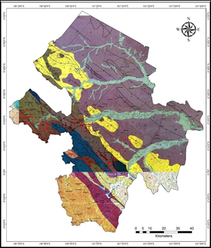
This research was conducted in the area of Kampar Regency, Riau Province .it was located at coordinates including 01° 00' 40" - 00° 27' 00" South Latitude and 100° 28' 30"- 101° 14' 30" East Longitude. The purpose of this study was to determine the geological condition of the watershed, and it was determined the geomorphological condition of the watershed, to determine the number of divisions of the watershed, to determine the relationship between the watershed and rainfall, to determine the geological and geomorphological relationship with the watershed in the study area. The method used starts from field sampling, core description, distribution analysis of geological data, geomorphology, watershed analysis, and analysis of rainfall. Based on the analysis of the distribution of geological data in the research area, there were 12 geological formations from the results of geological mapping, namely: the Sihapas Formation, the Telisa Formation, the bekasap formation, the Bahorok Formation, the Farmer Formation, the Manggala formation, the Talang Akar formation, the Telisa Atas formation, the Palembang Tengah formation, Basement, members of the Lower Palembang formation (Air Berakat), members of the Upper Palembang formation (Muara Enim). In subsurface geology there were 8 well points in the study area, 2 correlations were carried out, namely the 1st correlation between CR-04, CR-03, CR-01, CR-02, CR-08, and the 2nd correlation between CR-05, CR-06, CR- 07. Geomorphological conditions were divided into 4 namely lowland areas, low hill areas, hilly areas, and high hill areas. The watersheds in the research area were divided into 2 watersheds, namely the Kampar and Siak watersheds. Watershed rainfall observations in the study area for 5 years from 2015 – 2019 were located at 5 different stations, with fluctuating rainfall intensity
Downloads
References
Ardiansyah, Muhammad; Suryani, E; Tarigan, S.D; dan Agus, F.(2005). Optimasi Perencanaan Penggunaan Lahan Dengan Bantuan SIG dan Soil and Water Assessment Tool: Suatu Studi di DAS Cijalupang, Jawa Barat.
Departemen Ilmu Tanah dan Sumberdaya Lahan, Fakultas Pertanian. Institut Pertanian Bogor.
Asdak, Chay, (2002). Hidrologi Dan Pengelolaan Daerah Aliran Sungai, Gajah Mada. University Press, Yogyakarta.
Belmont, P. (2011). Floodplain width adjustments in response to rapid base level fall and knickpoint migration. Geomorphology, 128(1–2), 92–101.
Clarke, M.C.G; Kartawa, W.; Djunuddin, A.; Suganda, E.; Bagdja, M., 1982.
Geological Map of The Pakanbaru Quadrangle, Sumatra. PPPG
Kastowo dan Silitonga, P.H., 1973, Peta Geologi Bersistem Lembar Solok, Sumatera: Direktorat Geologi, Bandung.
Khasanah K, Mulyoutami E, Ekadinata A, Asmawan T, Tanika L, Said Z, Van Noordwijk M, Leimona B. (2010). A Study of Rapid Hydrological Appraisal in the Krueng Peusangan Watershed, NAD, Sumatra. Working paper nr.123. Bogor, Indonesia. World Agroforestry Centre.
Kausarian, H., Batara, B., & Putra, D. B. E. (2018). The Phenomena of Flood Caused by the Seawater Tidal and its Solution for the Rapid-growth City: A case study in Dumai City, Riau Province, Indonesia. Journal of Geoscience, Engineering, Environment, and Technology, 3(1), 39-46.
Kausarian, H., Sri Sumantyo, J. T., Kuze, H., Aminuddin, J., & Waqar, M. M. (2017). Analysis of Polarimetric Decomposition, Backscattering Coefficient, and Sample Properties for Identification and Layer Thickness Estimation of Silica Sand Distribution Using L-Band Synthetic Aperture Radar. Canadian Journal of Remote Sensing, 43(2), 95-108.
Kausarian, H., Sumantyo, J. T. S., Kuze, H., Karya, D., & Panggabean, G. F. (2016). Silica Sand Identification using ALOS PALSAR Full Polarimetry on The Northern Coastline of Rupat Island, Indonesia. International Journal on Advanced Science, Engineering and Information Technology, 6(5), 568-573.
Moriasi, D.N., Arnold, J.G., Van Liew, M.W., Bingner, R.L., Harmel, R.D., dan Veith, T.L., (2001), Model Evaluation Guidelines, For, Systematic Quantification Of Accuracy In Watersshed Simulations, American Society of Agricultural and BiologicalEngineers 20(3):885-900.
Mosaad, S. (2017). Geomorphologic and geologic overview for water resources development: Kharitbasin, Eastern Desert, Egypt. Journal of African Earth Sciences.
Ningkuela, E, S. (2015). Analisis Characteristics Meteorologi Dan Morfologi Das Wai Samal Kecamatan Seram Utara Timur Kobi Kabupaten Maluku Tengah, Ternate, Jurnal Ilmiah agrabisnis dan Perikanan (agrikan UMMU-Ternate) volume 8 edisi 2.
Nugroho P. (2010). Prediksi Perubahan Neraca Air Nengan Model GenRiver (Studi Kasus di Sub DAS Goseng Kabupaten Karanganyar, Jawa Tengah) [tesis]. Yogyakarta: Universitas Gadjah Mada.
Saifudin, dkk. (2007). Pengkajian Daerah Resapan DAS Luk Ulo. Kabupaten Kebumen, Jawa Tengah, Prosiding Seminar Geotekmologi Kontribusi ilmu Kebumian Dalam Pembangunan Berkelanjutan ISBN :978-979-799-255-5.
Silitonga P.H. & Kastowo, 1995 : Peta Geologi Lembar Solok, Sumatera,. Peta Geologi Bersistem Sumatera, PPG, Bandung.
Triono, N, D. (2010). Kajian Hubungan Geomorfologi DAS dan Characteristics Hidrologi, Bogor, Departemen Teknik Pertanian Fakultas Teknologi Pertanian Institut Pertanian Bogor.
Van Bemmelen, R. W., (1949), The Geology of Indonesia vol. 1 A. Government Printing Office, the Hague, Martinus Nijhoff, vol. 1A, Netherlands
Van Zuidam. R.A., (1983), Aerial Photo Interpretation in Terrain Analysis and Geomorphologic Mapping. The Hague: Smits
WischMayer, W.H. and D.D. Smith. (1978). Predicting Rainfall Erosion Losses. US Dept. Agriculture Handbook. No. 537.
Yuskar, Y., & Choanji, T. (2016b). Sedimentologi Dasar (1st ed.). Pekanbaru, Indonesia: UIR PRESS. Barus et al. (2000), diacu dalam Febriani (2007),tiga tahapan untuk pembuatan produk SIG.
Downloads
Published
Issue
Section
License
Copyright @2019. This is an open-access article distributed under the terms of the Creative Commons Attribution-ShareAlike 4.0 International License which permits unrestricted use, distribution, and reproduction in any medium. Copyrights of all materials published in JGEET are freely available without charge to users or / institution. Users are allowed to read, download, copy, distribute, search, or link to full-text articles in this journal without asking by giving appropriate credit, provide a link to the license, and indicate if changes were made. All of the remix, transform, or build upon the material must distribute the contributions under the same license as the original.


