Modified Soil-Adjusted Vegetation Index In Multispectral Remote Sensing Data for Estimating Tree Canopy Cover Density at Rubber Plantation
Modified Soil-Adjusted Vegetation Index In Multispectral Remote Sensing Data
DOI:
https://doi.org/10.24273/jgeet.2018.3.01.1003Keywords:
Canopy Cover Density, Remote Sensing, ASTER Imagery, Transformation Vegetation IndexAbstract
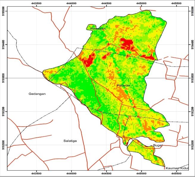
Forest inventories such as tree canopy density information require a long time and high costs, especially on extensive forest coverage. Remote sensing technology that directly captures the surface vegetation character with extensive recording coverage can be used as an alternative to carrying out such inventory activities. This research aims to determine the level of vegetation canopy cover density on rubber plants that became the location of the research and know the accuracy of the resulting data. The method used in this research is a combination of remote sensing image interpretation, geographic information system, and field measurement. Information retrieval from remote sensing data is done by using ASTER data imagery. This stage includes three parts, namely: pre-field stage, field stage, and post-field stage. The pre-field stage includes the collection of data to be used (including literature studies related to the theme of the study), image processing (geometric and radiometric correction), cropping, masking, land cover classification, vegetation index transformation, and sample determination. The final result of data processing showed that the density of the vegetation canopy in the research area ranged between 7.31 – 12.952 cm / m2 in each grade of vegetation density. These values indicate the range of low-class vegetation canopy cover density to high-class vegetation canopy cover density in the research area. In this research error rate or root mean square error obtained from the calculation of canopy cover density is equal to 1.89.
Downloads
References
Anurogo, W., Murti, S.H. and Khakhim, N., 2015. Analisis Perubahan Hutan Mangrove Dalam Penentuan Kawasan Rehabilitasi Dan Perubahan Stok Karbon Menggunakan Data Penginderaan Jauh (Di Teluk Banten, Serang Provinsi Banten) (Doctoral dissertation, Universitas Gadjah Mada).
Anurogo, W. and Murti, S.H., Aplikasi Penginderaan Jauh Untuk Estimasi Produksi Tanaman Karet (Hevea Brasiliensis) Di Kota Salatiga, Jawa Tengah.
Danoedoro, P., 2012. Pengantar penginderaan jauh digital. Yogyakarta: Andi.
Diniyati, D. and Achmad, B., 2015. Kontribusi Pendapatan Hasil Hutan Bukan Kayu pada Usaha Hutan Rakyat Pola Agroforestri di Kabupaten Tasikmalaya. Jurnal Ilmu Kehutanan, 9(1), pp.23-31.
Karlinasari, L., Sabed, M., Wistara, N.J., Purwanto, A. and Wijayanto, H., 2012. Karakteristik Spektra Absorbansi NIR (Near Infra Red) Spektroskopi Kayu Acacia mangium WILLD pada 3 Umur Berbeda. Jurnal Ilmu Kehutanan, 6(1), pp.45-52.
Lubis, M.Z., Anggraini, K., Kausarian, H. and Pujiyati, S., 2017. Marine Seismic And Side-Scan Sonar Investigations For Seabed Identification With Sonar System. Journal of Geoscience, Engineering, Environment, and Technology, 2(2), pp.166-170.
Nadi, P.A. and Murad, A., 2017. Reviewing the use of Geographic Information System (GIS) to measure Sustainable Urban Transport performance. Journal of Geoscience, Engineering, Environment, and Technology, 2(2), pp.171-177.
Noormasari, M. and Murti, S.H., 2014. Pemanfaatan Citra Alos Avnr-2 Untuk Estimasi Produksi Tanaman Jati Dengan Menggunakan Metode Transformasi Spektral Indeks Vegetasi (Daerah Kajian: Sebagian Kabupaten Gunung Kidul) (Doctoral dissertation, Universitas Gadjah Mada).
Raharjo, J.T. and Sadono, R., 2008. Model Tajuk Jati (Tectona grandis LF) Dari Berbagai Famili Pada Uji Keturunan Umur 9 Tahun. Jurnal Ilmu Kehutanan, 2(2), pp.89-95.
Sari, D.P. and Lubis, M.Z., 2017. Pemanfaatan Citra Landsat 8 Untuk Memetakan Persebaran Lamun Di Wilayah Pesisir Pulau Batam. Jurnal Enggano, 2(1).
Sukarna, R.M., Perubahan Struktur dan Komposisi Hutan Rawa Gambut Menggunakan Citra Penginderaan Jauh dan Pendekatan Ekologis di Kawasan Bekas Pengembangan Lahan Gambut Provinsi Kalimantan Tengah. Jurnal Ilmu Kehutanan, 7(2), pp.129-146.
Taki, H.M., Maatouk, M.M.H., Qurnfulah, E.M. and Aljoufie, M.O., 2017. Planning TOD with land use and transport integration: a review. Journal of Geoscience, Engineering, Environment, and Technology, 2(1), pp.84-94.
Downloads
Published
Issue
Section
License
Copyright @2019. This is an open-access article distributed under the terms of the Creative Commons Attribution-ShareAlike 4.0 International License which permits unrestricted use, distribution, and reproduction in any medium. Copyrights of all materials published in JGEET are freely available without charge to users or / institution. Users are allowed to read, download, copy, distribute, search, or link to full-text articles in this journal without asking by giving appropriate credit, provide a link to the license, and indicate if changes were made. All of the remix, transform, or build upon the material must distribute the contributions under the same license as the original.