Mapping Of Vegetation And Mangrove Distribution Level In Batam Island Using SPOT-5 Satellite Imagery
DOI:
https://doi.org/10.24273/jgeet.2017.2.4.1002Keywords:
Mangrove, Vegetation Index, MSAVI, SPOT-5 Satellite ImageryAbstract
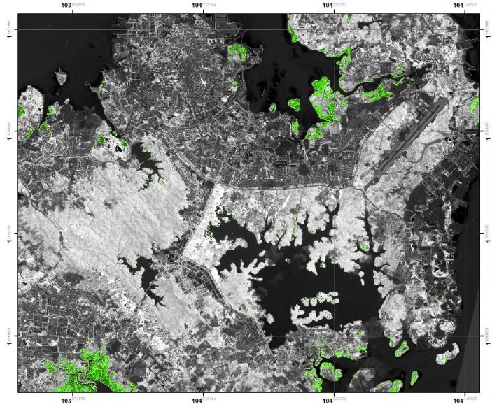
Mangrove is a plant that plays a significant role in the balance of the ecosystem and coastal environment. Batam Island which is one of the island in Batam island become one of the areas rich in mangrove plants. As time goes by, mangrove forests are getting worse. This research uses SPOT-5 imagery data in analyzing mangrove density value in Batam island with MSAVI (Modified Soil Adjusted Vegetation Index) method. The results of this study have mangrove density in Batam Island which is divided into four classes, which is very tenuous, tenuous, medium, and very tightly where Batam Island is dominated by a class of density. Theoretically, NDVI values range from -1 to +1 but the mangrove vegetation index values are generally in the range between +0,1 to +0,7. NDVI values greater than this range are associated with a representation of a better level of vegetation health in the islands of Batam.
Downloads
References
Anurogo, W., Lubis, M.Z., Khoirunnisa, H., Pamungkas, D.S., Hanafi, A., Rizki, F., Surya, G., Situmorang, A.D.L., Timbang, D., Sihombing, P.N. and Lukitasari, C.A., 2017. A Simple Aerial Photogrammetric Mapping System Overview and Image Acquisition Using Unmanned Aerial Vehicles (UAVs). Journal of Applied Geospatial Information, 1(01), pp.11-18.
ANUROGO, W., Murti, S.H. and Khakhim, N., 2015. Analisis Perubahan Hutan Mangrove Dalam Penentuan Kawasan Rehabilitasi Dan Perubahan Stok Karbon Menggunakan Data Penginderaan Jauh (Di Teluk Banten, Serang Provinsi Banten) (Doctoral dissertation, Universitas Gadjah Mada).
Conchedda, G., Durieux, L. and Mayaux, P., 2008. An object-based method for mapping and change analysis in mangrove ecosystems. ISPRS Journal of Photogrammetry and Remote Sensing, 63(5), pp.578-589.
Farizki, M. and Anurogo, W., 2017. Pemetaan kualitas permukiman dengan menggunakan penginderaan jauh dan SIG di kecamatan Batam kota, Batam. Majalah Geografi Indonesia, 31(1), pp.39-45.
Green, E.P., P.J. Mumbay, A.J. Edwards, and C.D. Clark. 2000. Remote Sensing Hand Book for Tropical Coastal Management.Unesco Publishing.
Hidayah, Z. and Wiyanto, D.B., 2013. Analisa Temporal Perubahan Luas Hutan Mangrove Di Kabupaten Sidoarjo dengan Memanfaatkan Data Citra Satelit. Jurnal Bumi Lestari, 13(2).
Huete, A.R., 1988. A soil-adjusted vegetation index (SAVI). Remote sensing of environment, 25(3), pp.295-309.
Lubis, M.Z. and Daya, A.P., 2017. Pemetaan Parameter Oseanografi Fisik Menggunakan Citra Landsat 8 di Wilayah Perairan Nongsa Pulau Batam. Jurnal Integrasi, 9(1), pp.9-15.
Lubis, M.Z., Sari, D.P., Aprilliyanti, T., Daulay, A.K., Hanafi, A., Ananda, F., Saputri, D.A., Aminah, S., Zabid, M.A.P. and Ibrahim, M.M.R., 2017. Penggunaan Citra Landsat 8 untuk Pemetaan Persebaran Lamun di Pesisir Pulau Batam. Dinamika Maritim, 6(1), pp.7-11.
Purwanto, A.D., Asriningrum, W., Winarso, G. and Parwati, E., 2014. Analisis Sebaran dan Kerapatan Mangrove Menggunakan Citra Landsat 8 di Segara Anakan, Cilacap. In Proceeding of Seminar Nasional Penginderaan Jauh. Bogor.
Sari, D.P. and Lubis, M.Z., 2017. Pemanfaatan Citra Landsat 8 Untuk Memetakan Persebaran Lamun Di Wilayah Pesisir Pulau Batam. Jurnal Enggano, 2(1).
Suwargana, N., Santo, J., LAPAN, J.L. and Timur, P.P.R.J., 2008. Updating Informasi Spasial Tutupan Lahan Propinsi Kalimantan Selatan Dengan Menggunakan Citra Landsat-7/ETM+. LAPAN, Jalan LAPAN, 70.
Downloads
Published
Issue
Section
License
Copyright @2019. This is an open-access article distributed under the terms of the Creative Commons Attribution-ShareAlike 4.0 International License which permits unrestricted use, distribution, and reproduction in any medium. Copyrights of all materials published in JGEET are freely available without charge to users or / institution. Users are allowed to read, download, copy, distribute, search, or link to full-text articles in this journal without asking by giving appropriate credit, provide a link to the license, and indicate if changes were made. All of the remix, transform, or build upon the material must distribute the contributions under the same license as the original.