
Groundwater exploration using Vertical Electrical Sounding (VES) Method at Toro Jaya, Langgam, Riau
DOI:
https://doi.org/10.24273/jgeet.2018.3.4.2226Keywords:
Groundwater, Vertical Electrical Sounding (VES), Schlumberger, AquiferAbstract
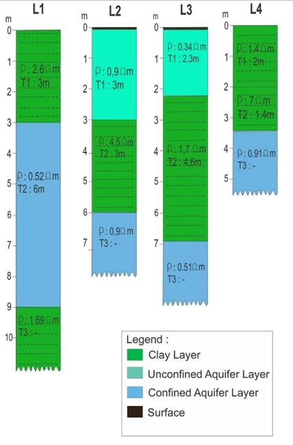
Vertical Electrical Sounding (VES) method is one of many methods in geophysics that was conducted in this research at Toro Jaya, Langgam, Riau. The aim of this research is to investigate and locate the depth of groundwater layer (aquifer). Data acquisition of VES was carried out using GEOCIST with Schlumburger configuration of electrode. There are four VES point in this research with various length of cable ranging from 135 m up to 200 m. From four VES point shown two different of resistivity value range. Very low resistivity value with range 0,34 – 0,9 Ωm interpreted as aquifer layer. The aquifer layer of research area divided into two types which are unconfined aquifer and confined aquifer. Meanwhile, another resistivity value ranging from 1,69 – 7 Ωm was interpreted as clay layers.
Downloads
References
Azhar, M.A., Suryadi, A., Samsudin, A.R., Yaacob, W.Z.W., Saidin, A.N., 2016. 2D Geo-Electrical Resistivity Imaging (ERI) of Hydrocarbon Contaminated Soil. EJGE ( Electron. J. Geotech. Eng. 21, 299–304.
Chandra, S., Dewandel, B., Dutta, S., Ahmed, S., 2010. Geophysical model of geological discontinuities in a granitic aquifer: Analyzing small scale variability of electrical resistivity for groundwater occurrences. J. Appl. Geophys. 71, 137–148. https://doi.org/10.1016/j.jappgeo.2010.06.003
Clarke, J.., Kartawa, W., Djunuddin, A., Suganda, E., Bagdja, M., 1982. Geological Map of The Pekanbaru Quadrangle, Sumatra. PPPG.
Hamzah, U., Ismail, M.A., Samsudin, A.R., 2008. Geophysical techniques in the study of hydrocarbon-contaminated soil 54, 133–138. https://doi.org/10.7186/bgsm2008020
Hamzah, U., Samsudin, A.R., Malim, E.P., 2007. Groundwater investigation in Kuala Selangor using vertical electrical sounding (VES) surveys. Environ. Geol. 51, 1349–1359. https://doi.org/10.1007/s00254-006-0433-8
Jumary, S.Z., Hamzah, U., Samsudin, A.R., 2002. Teknik-teknik geoelektrik dalam Pemetaan air masin di Kuala ( Mapping of groundwater salinity at Kuala Selangor by geoelectrical techniques ).
Kausarian, H., Batara, B., Putra, D.B.E., 2018. The Phenomena of Flood Caused by the Seawater Tidal and its Solution for the Rapid-growth City: A case study in Dumai City, Riau Province, Indonesia. J. Geosci. Eng. Environ. Technol. 3, 39–46. https://doi.org/10.24273/jgeet.2018.3.01.1221
Putra, D.B.E., Yuskar, Y., 2017. Pemetaan Airtanah Dangkal Dan Analisis Intrusi Air Laut, Penelitian Terhadap Airtanah Dangkal di Sesa Bantan Tua, Kecamantan Bantan, Kabupaten Bengkalis, Propinsi Riau, in: Seminar Nasional Ke-III Faklutas Teknik Geologi Universitas Padjadjaran.
Yuskar, Y., Choanji, T., 2017. Uniqueness Deposit of Sediment on Floodplain Resulting From Lateral Accretion on Tropical Area. J. Geosci. Eng. Environ. Technol. 2, 14. https://doi.org/10.24273/jgeet.2017.2.1.12
Yuskar, Y., Choanji, T., 2016a. Sedimen Deposit of Floodplain Formation Resulting From Lateral Accretion Surfaces on Tropical Area: Study Case at Kampar River, Indonesia, in: IJJSS 7th (Indonesia Japan Joint Scientific Symposium).
Yuskar, Y., Choanji, T., 2016b. Sedimentologi Dasar, 1st ed. UIR PRESS, Pekanbaru, Indonesia.
Yuskar, Y., Putra, D.B.E., Revanda, M., 2018. Quarternary Sediment Characteristics of Floodplain area: Study Case at Kampar River, Rumbio Area and Surroundings, Riau Province. J. Geosci. Eng. Environ. Technol. 3, 63. https://doi.org/10.24273/jgeet.2018.3.1.1226
Downloads
Published
Issue
Section
License
Copyright @2019. This is an open-access article distributed under the terms of the Creative Commons Attribution-ShareAlike 4.0 International License which permits unrestricted use, distribution, and reproduction in any medium. Copyrights of all materials published in JGEET are freely available without charge to users or / institution. Users are allowed to read, download, copy, distribute, search, or link to full-text articles in this journal without asking by giving appropriate credit, provide a link to the license, and indicate if changes were made. All of the remix, transform, or build upon the material must distribute the contributions under the same license as the original.


