Geology Structure Identification Using Pre-Stack Depth Migration (PSDM) Method of Tomography Result in North West Java Basin
DOI:
https://doi.org/10.24273/jgeet.2017.2.2.297Keywords:
North West Java, Geology structure, Pre-Stack Depth Migration (PSDM), FaultAbstract
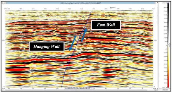
North West Java Basin is a tertiary sedimentary basin which is located in the right of the western part of the Java island. North West Java Basin is geodynamic where currently located at the rear position of the path of the volcanic arc of Java that is the result of the India-Australia plate subduction to the south towards the Eurasian plate (Explanation of Sunda) in the north. Geology structure observation is difficult to be conducted at Quaternary volcanicfield due to the classical problem at tropical region. In the study interpretation of fault structures can be done on a cross-section of Pre-Stack Depth Migration (PSDM) used prayer namely Hardware Key Device, ie Central Processing Unit: RedHat Enterprise Linux AS 5.0, prayer Monitor 24-inch pieces, Server: SGI altix 450/SuSe Linux Enterprise Server 9.0, 32 GB, 32 X 2,6 GHz Procesor, network: Gigabyte 1 Gb/s, and the software used is paradigm, product: Seismic Processing and Imaging. The third fault obtained in this study in accordance with the geological information derived from previous research conducted by geologists. The second general direction is northwest-southeast direction represented by Baribis fault, fault-fault in the Valley Cimandiri and Gunung Walat. This direction is often known as the directions Meratus (Meratus Trend). Meratus directions interpreted as directions that follow the pattern of continuous arc Cretaceous age to Meratus in Kalimantan.
Downloads
References
Arpandi D., dan Patmosukismo, S., 1975, The Cibulakan Formation as One of the Most Prospective Stratigrahpic Units in the North West Java Basinal Area, Proceedings of Indonesian Petroleum Association, 4th Annual Convention.
Gresko, M., Suria, C. and Sinclair, S., 1995. Basin evolution of the Ardjuna rift system and its implications for hydrocarbon exploration, offshore Northwest Java, Indonesia.
Katili, J.A., 1978. Past and present geotectonic position of Sulawesi, Indonesia. Tectonophysics, 45(4), pp.289-322.
Lubis, M. Z., Anurogo, W., Khoirunnisa, H., Irawan, O. G., & Roziqin, A. 2017. Using Side-Scan Sonar instrument to characterize and map of seabed for identification target in punggur sea of the Riau islands. JGEET (JOURNAL OF GEOSCIENCE, ENGINEERING, ENVIRONMENT, AND TECHNOLOGY), 2(1).
Martodjojo, S., 2003. Evolusi Cekungan Bogor Jawa Barat. Penerbit ITB Bandung.
Natasia, N., Syafri, I., Alfadli, M.K., Arfiansyah, K., 2016. Stratigraphy Seismic and sedimentation Development of Middle Baong Sand , Aru Field ,North Sumatera Basin. J. Geoscience, Engineering, Environment, and Technology 1, 51–58.
Noble, R.A., Pratomo, K.H., Nugrahanto, K., Ibrahim, A.M., Prasetya, I., Mujahidin, N., Wu, C.H. and Howes, J.V.C., 1997. Petroleum systems of northwest Java, Indonesia.
Pradipta, R. A., & Saepuloh, A. 2016. Geology Structure Identification based on Polarimetric SAR (PolSAR) Data and Field Based Observation at Ciwidey Geothermal Field. In IOP Conference Series: Earth and Environmental Science (Vol. 42, No. 1, p. 012008). IOP Publishing.
Setiawan, N. I., Osanai, Y., Nakano, N., Adachi, T., & Asy’ari, A. 2015. Metamorphic Evolution of Garnet-bearing Epidote-Barroisite Schist from the Meratus Complex in South Kalimantan, Indonesia. Indonesian Journal on Geoscience, 2(3), 139-156.
Sheriff, R.E., 2002. Encyclopedic dictionary of applied geophysics. Society of exploration geophysicists.
Sudra Irawan, Sismanto, & Adang Sukmatiawan.2014. Applying the Horizon Based Tomography Method to Update Interval Velocity Model, Identify the Structure of Pre-Stack Depth Migration 3D and Estimate the Hydrocarbon Reserve in SBI Field of North West Java Basin. Jurnal Teknologi,69(6), 53-58.
Downloads
Published
Issue
Section
License
Copyright @2019. This is an open-access article distributed under the terms of the Creative Commons Attribution-ShareAlike 4.0 International License which permits unrestricted use, distribution, and reproduction in any medium. Copyrights of all materials published in JGEET are freely available without charge to users or / institution. Users are allowed to read, download, copy, distribute, search, or link to full-text articles in this journal without asking by giving appropriate credit, provide a link to the license, and indicate if changes were made. All of the remix, transform, or build upon the material must distribute the contributions under the same license as the original.