Preliminary Analysis of Slope Stability in Kuok and Surrounding Areas
DOI:
https://doi.org/10.24273/jgeet.2016.11.5Keywords:
Kuok, Landslide, Slope Stability Analysis, Toppling Failure, Rock FallAbstract
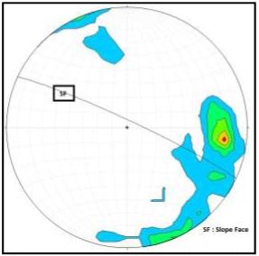
The level of slope influenced by the condition of the rocks beneath the surface. On high level of slopes, amount of surface runoff and water transport energy is also enlarged. This caused by greater gravity, in line with the surface tilt from the horizontal plane. In other words, topsoil eroded more and more. When the slope becomes twice as steep, then the amount of erosion per unit area be 2.0 - 2.5 times more. Kuok and surrounding area is the road access between the West Sumatra and Riau which plays an important role economies of both provinces. The purpose of this study is to map the locations that have fairly steep slopes and potential mode of landslides. Based on SRTM data obtained, the roads in Kuok area has a minimum elevation of + 33 m and a maximum + 217.329 m. Rugged road conditions with slope ranging from 24.08 ° to 44.68 ° causing this area having frequent landslides. The result of slope stability analysis in a slope near the Water Power Plant Koto Panjang, indicated that mode of active failure is toppling failure or rock fall and the potential zone of failure is in the center part of the slope.
Downloads
References
[2] Brown, K.D. (2010). ”Creating Slope-Enhanced Shaded-Relief Using Global Mapper. Utah Geological Survey.
[3] Burrough, P.A., dan McDonell, R.A. (1998). “Principles of Geographical Information Systems”. Oxford University Press, New York.
[4] Gorokhovich, Y., Voustianiouk, A. (2006). “Accuracy assessment of the processed SRTM-based elevation data by CGIAR using field data from USA and Thailand and its arelation to the terrain characteristics”. Journal of Remote Sensing of Environtment. Elsevier. 409-415.
[5] Hasrullah, (2011). “Studi Pengaruh Infiltrasi Air Hujan Terhadap Kestabilan Lereng”. Jurusan Teknik Sipil Fakultas Teknik Universitas Borneo. Tarakan.
[6] Ibanez, D.M., de Miranda, F.P., Riccomini, C.(2014). “Geomorphometric pattern recognition of SRTM data applied to the tectonic interpretation of the Amazonian landscape”. ISPRS Journal of Photogrametry and Remote Sensing. Elsevier.
[7] Kliche, C.A. (1999) “Rock Slope Stability”. SME, Littleton, CO.
[8] LeFavour, G., Alsdorf, D. (2005). “Water slope and discharge in the Amazon River estimated using the shuttle radar topography mission digital elevation model. Geophysical Research Letter vol 32. 1-5.
[9] Metcalfe, I. (2011). “Tectonic framework and Phanerozoic evolution of Sundaland”. Journal Gondwana Research. Elsevier.
[10]Nugraha, A. (2012). “Analisis Penggabungan Data DEM SRTM 30 dengan Data Kontur (RBI) Menggunakan Metode Integrasi Untuk Perbaikan Tingkat Akurasi DEM”. Program Studi Teknik Geodesi, Fakultas Teknik, Universitas Diponegoro, Semarang..
[11]Park H.J. Lee, J.H., Kim K.M., Um, J.G. (2016). “Assessment of rock slope stability using GIS-based probabilistic kinematic analysis”. Journal of engineering geology. Elsevier..
[12] Rock, N.S., Aldiss D.T., Aspden, J.A., Clarke , M.C.G., Djunuddin, A., Kartawa, W., Miswar, Thompson, S.J., Whandhoyo, R., (1983). “Peta lembar Lubuk Sikaping, Sumatera”. Pusat Penelitian dan Pengembangan Geologi, Bandung, Indonesia.
[13]Szabó, G., Singh, S.K., Szabó S. (2015). “Slope angle and aspect as influencing factors on the accuracy of the SRTM and the ASTER GDEM databases”. Journal of Physics and Chemistry of Earth vol 83 – 84. Elsevier
[14]van Zuidam R.A. (1973). “Terrain Analysis and Classification Using Aerial Photographs: A Geomorphological Approach”. International Institute for Aerial Survey and Earth Sciences (ITC).
[15]Wyllie, D.C., Mah, C.W. (2004) “Rock Slope Engineering: Civil and Mining. 4th Edition”. Spon Press, New York
[16] Yadi Z. (2014). “Kestabilan Geometri Lereng Bukaan Tambang di PT. Pasifik Global Utama Kabupaten Muara Enim, Provinsi Sumatra Selatan”. Prosiding Penelitian Sivitas Akademika Unisba (Sains dan Teknologi).
[17]Zulfiadi Zakaria. (2009). “Analisis Kestabilan lereng Tanah”. Program Studi Teknik Geologi Fakultas Teknik Geologi. Universitas Padjajaran. Bandung.
Downloads
Published
Issue
Section
License
Copyright @2019. This is an open-access article distributed under the terms of the Creative Commons Attribution-ShareAlike 4.0 International License which permits unrestricted use, distribution, and reproduction in any medium. Copyrights of all materials published in JGEET are freely available without charge to users or / institution. Users are allowed to read, download, copy, distribute, search, or link to full-text articles in this journal without asking by giving appropriate credit, provide a link to the license, and indicate if changes were made. All of the remix, transform, or build upon the material must distribute the contributions under the same license as the original.