Structural Geology Analysis In A Disaster-Prone Of Slope Failure, Merangin Village, Kuok District, Kampar Regency, Riau Province
DOI:
https://doi.org/10.24273/jgeet.2017.2.4.691Keywords:
Landslide, Geological Structure, RQD, Rock Mass RatingAbstract
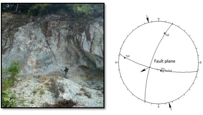
The geological disaster of landslide has occurred in Merangin Village, Kuok Subdistrict, Kampar Regency, Riau Province which located exactly in the national road of Riau - West Sumatra at Km 91. Based on the occurrence of landslide, this research was conducted to study geological structure and engineering geology to determine the main factors causing landslides. Based on measurement of the structural geology found on research area, there were fractures, faults and fold rocks which having trend of stress N 2380 E, plunge 60, trending NE-SW direction. Several faults that found was normal faults directing N 2000 E with dip 200 trending from northeast-southwest and reverse fault impinging N 550 E with dip 550, pitch 200 trending to the northeast. Fold structures showing azimuth N 2010 E trending southeast-northwest. From geological engineering analysis, the results of scan line at 6 sites that have RQD value ranges 9.4% - 78.7 % with discontinuity spacing 4 - 20 cm. So, It can be concluded that the formed structure was influenced by the extensive northeast-southwest tectonic phase, then continued through north-south tectonic phase, and ended by a tectonic period with directing from northeast-southwest. Rock Mass Rating classification showing value 62 – 76, Which also resulted that rocks in the study area have weathered on the outside but still in good condition (good rock). However, This condition of structure has caused the formation rocks producing weak zone that became one cause of the occurrence of landslides.
Downloads
References
Clarke drr., P3G .1982. Peta Geologi Lembar Pakanbaru, Sumatera. Pusat Penelitian dan Pengembangan Geologi, Bandung.
Eubank, R.T., & Makki, A. C., 1981, Structural Geology of The Central Sumatra Back-arc Basin, Proceeding IPA, 10th Annual Convention, p 285 – 317.
Heidrick, T.L., dan Aulia, K., 1993, A Structural and Tectonic Model of The Coastal Plain Block, Central Sumatra Basin, Indonesia, Proceeding IPA, 22th Annual Convention, Jakarta.
McKean J, Roering J .2004. Objective Landslide Detection and Surface Morphology Mapping Using High-resolution Airborne Laser Altimetry. Geomorphology;57:331–351. Papagiannaki, K., Lagouvardos, K., & Kotroni, V .2013. A database of high-impact weather events in Greece: a descriptive impact analysis for the period 2001e 2011. Natural Hazards and Earth System Science, 13, 727e736. http://dx.doi.org/ 10.5194/nhess-13-727-2013.
Raghuvanshi, T.K., Ibrahim, J., Ayalew, D .2014. Slope stability susceptibility evaluation parameter (SSEP) rating scheme – an approach for landslide hazard zonation. J. Afr. Earth Sci. 99, 595– 612.
Putra, D.B.E., Choanji, T., 2016. Preliminary Analysis of Slope Stability in Kuok and Surrounding Areas. J. Geosci. Eng. Environ. Technol. 1, 41–44.
Pulonggono, A and Cameron, N. R.., 1984, Sumatran Microplate, their characteristic and their role in Evolution of Central Sumatra Basins: Proceedings Indonesian Petroleum Association, 13th Annual Convention, p. 121 – 143.
Saputra, H.N and Sapiie, B., 2005, Analogue Study of Basement Fractured Reservoirs in Kotopanjang Area, Central Sumatra: Proceedings Indonesian Petroleum Association, 33th Annual Convention.
Tarolli P, Sofia G, Dalla Fontana G .2012. Geomorphic Features Extraction from High-resolution Topography: Landslide Crowns and Bank Erosion. Nat Hazards 2012;61:65–83.
Wirtz, A., Kron, W., Löw, P., & Steuer, M .2012. The need for data: natural disasters and the challenges of database management. Natural Hazards, 1e23. http:// dx.doi.org/10.1007/s11069-012-0312-4.
Downloads
Published
Issue
Section
License
Copyright @2019. This is an open-access article distributed under the terms of the Creative Commons Attribution-ShareAlike 4.0 International License which permits unrestricted use, distribution, and reproduction in any medium. Copyrights of all materials published in JGEET are freely available without charge to users or / institution. Users are allowed to read, download, copy, distribute, search, or link to full-text articles in this journal without asking by giving appropriate credit, provide a link to the license, and indicate if changes were made. All of the remix, transform, or build upon the material must distribute the contributions under the same license as the original.