
Quarternary Sediment Characteristics of Floodplain area: Study Case at Kampar River, Rumbio Area and Surroundings, Riau Province
DOI:
https://doi.org/10.24273/jgeet.2018.3.1.1226Keywords:
Quaternary Sediment, floodplain, facies, Meander River, KamparAbstract
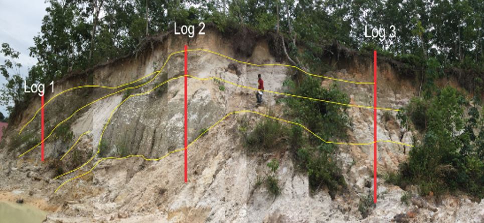
The study area is located in some floodplains of meandering river environment along the Kampar River, Rumbio. Typical morphology of meandering river that found in this area can be classified as stream channel, floodplain, abandoned channel, and sand bars deposit. Meandering river system carries sediment supply by suspended and bed - load (mixed load) in conjunction with low energy into a particular characteristic on sediment deposition. This study aims to determine the characteristics of the sediments, changes in vertical and lateral spread of sediment deposition on the floodplain environment. This study conducted by field survey using a hand auger of 1.5m - 4m depth and trenching which is a layer that has been exposed of 1-2 meters depth. Further analysis had been carried out using granulometri method and core data analysis to determine the characteristics and depositional facies. Sediment deposit that formed along the Kampar River is the result of the main channel migration of Kampar River. The characteristic of quaternary sediment facies is coarse to gravelly sand on the bottom followed by fine to very fine sand with pattern fining upwards and silt to clay and abundant terrestrial organic matter at the uppermost layer. Depositional facies are determined based on the characteristics of sediment facies which can be grouped into a stream channel, oblique accretion deposits, sand bars and overbank deposits.
Downloads
References
Choanji, T., Rita, N., Yuskar, Y., Pradana, A., 2018. Connectivity Relationship of Fluid Flow On Deformation Band: Analog Study at Petani Formation, Riau, Indonesia. Bull. Sci. Contrib. Geol. 15, 193–198.
Clarke, M.C.G; Kartawa, W.; Djunuddin, A.; Suganda, E.; Bagdja, M. (1982). Geological Map of The Pakanbaru Quadrangle, Sumatra. PPPG.
Knox, J.C., 2006. Floodplain sedimentation in the Upper Mississippi Valley: Natural versus human accelerated. Geomorphology 79, 286–310. doi:10.1016/j.geomorph.2006.06.031
Lauer, J.W., Parker, G., 2008. Net local removal of floodplain sediment by river meander migration. Geomorphology 96, 123–149. doi:10.1016/j.geomorph.2007.08.003
Michael P. O’neill And Athol D. Abrahams, 1986. The problem of quantitatively characterizing the plan geometry of mean- dering stream channels has intrigued engineers and earth scientists for more than 80 yrs (Jefferson, 1902). J. Hydrol. 83 337--353 Elsevier Sci. Publ. B.V., Amsterdam -- Print. Netherlands [1l 83, 337–353.
Nichols, G., 2009. Sedimentology and stratigraphy, Journal of Chemical Information and Modeling. doi:10.1017/CBO9781107415324.004
Pierce, A.R., King, S.L., 2008. Spatial dynamics of overbank sedimentation in floodplain systems. Geomorphology 100, 256–268. doi:10.1016/j.geomorph.2007.12.008
Posamentier, Roger G.; Walker, H. W. (2006). Facies Models Revisited. (H. W. Posamentier, Roger G.; Walker, Ed.). SEPM Society for Sedimentary Geology.
Stanistreet, I.G., Cairncross, B., McCarthy, T.S., 1993. Low sinuosity and meandering bedload rivers of the Okavango Fan: channel confinement by vegetated levées without fine sediment. Sediment. Geol. 85, 135–156. doi:10.1016/0037-0738(93)90079-K
Wood, S.H., Ziegler, A.D., Bundarnsin, T., 2008. Floodplain deposits, channel changes and riverbank stratigraphy of the Mekong River area at the 14th-Century city of Chiang Saen, Northern Thailand. Geomorphology 101, 510–523. doi:10.1016/j.geomorph.2007.04.030
Yuskar, Y., 2016. Geo-tourism Potential of Sand Bars and Oxbow lake at Buluh. J. Geosci. Eng. Environ. Technol. 1, 59–62.
Yuskar, Y., Choanji, T., 2017. Uniqueness Deposit of Sediment on Floodplain Resulting From Lateral Accretion on Tropical Area : Study Case at Kampar River , Indonesia 2, 14–19.
Downloads
Published
Issue
Section
License
Copyright @2019. This is an open-access article distributed under the terms of the Creative Commons Attribution-ShareAlike 4.0 International License which permits unrestricted use, distribution, and reproduction in any medium. Copyrights of all materials published in JGEET are freely available without charge to users or / institution. Users are allowed to read, download, copy, distribute, search, or link to full-text articles in this journal without asking by giving appropriate credit, provide a link to the license, and indicate if changes were made. All of the remix, transform, or build upon the material must distribute the contributions under the same license as the original.


