
Geotourism on XIII Koto Kampar: an Approach for Sustainable Eco-Geo System
DOI:
https://doi.org/10.25299/jgeet.2019.4.4.3783Keywords:
Geotourism, Geology, Geomorphology, Sustainable, XIII Koto KamparAbstract
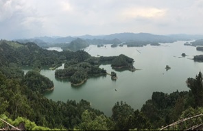
XIII Koto Kampar has become one of the potential geotourism destinations in Riau Province. The beauty of geomorphological view of XIII Koto Kampar is the main attraction for tourism. This study aims to expose the uniqueness of geological conditions that form the geomorphological of study for educational, social and economic purposes. The method used for this study is a combination of geological and geomorphological mapping and assess the inventory of geosites. Geomorphological of study area is consist of wide lake with some islands on it. Based on the elevation, geomorphology of study area devided into four which are flatland, gentle hill, steep hill and very steep hill. The result of geological mapping shown there are two dominated rock claystone and sandstone. Geotourism potential of study area classified into three main zone namely geomorphological landscape zone, water play zone and waterfall zone. Sustainable system of geotourism of XIII Koto Kampar is potential livelihood to increase the economical of local society.
Downloads
References
Kausarian, H., Batara, B., Eka Putra, D.B., Suryadi, A., Lubis, M.Z., 2018. Geological Mapping and Assessment for Measurement the Electric Grid Transmission Lines in West Sumatera Area, Indonesia. Int. J. Adv. Sci. Eng. Inf. Technol. 8, 856. https://doi.org/10.18517/ijaseit.8.3.4069
Kausarian, H., Lei, S., Lai, G.T., Cui, Y., Suryadi, A., 2019. A New Geological Map of Formation Distribution on Southern Part of South China Sea:; Natuna Island, Indonesia, in: IOP Conference Series: Materials Science and Engineering. https://doi.org/10.1088/1757-899X/532/1/012020
Kausarian, H., Sumantyo, J.T.S.S., Karya, D., Putra, D.B.E., Kadir, E.A., 2016. Geological Mapping for the Land Deformation Using Small UAV, DinSAR Analysis and Field Observation at the Siak Bridge I and II, Pekanbaru City, Indonesia, in: The 7th Indonesia Japan Joint Scientific Symposium (IJJS 2016). pp. 452–458.
Koh, Y.K., Oh, K.H., Youn, S.T., Kim, H.G., 2014. Geodiversity and geotourism utilization of islands: Gwanmae Island of South Korea. J. Mar. Isl. Cult. 3, 106–112. https://doi.org/10.1016/j.imic.2014.09.002
Newsome, D., Dowling, R., Leung, Y.F., 2012. The nature and management of geotourism: A case study of two established iconic geotourism destinations. Tour. Manag. Perspect. 2–3, 19–27. https://doi.org/10.1016/j.tmp.2011.12.009
Rocha, F., Ferreira da Silva, E., 2014. Geotourism, medical geology and local development: Cape Verde case study. J. African Earth Sci. 99, 735–742. https://doi.org/10.1016/j.jafrearsci.2014.04.015
Solarska, A., Jary, Z., 2010. Geoheritage and geotourism potential of the Strzelin Hills (Sudetic Foreland, SW Poland). Geogr. Pannonica 14, 109–116. https://doi.org/10.5937/geopan1004118s
Suryadi, A., 2016. Fault analysis to Determine Deformation History of Kubang Pasu Formation at South of UniMAP Stadium Hill , Ulu Pauh ,. JGEET (Journal Geosci. Eng. Environ. Technol. 1, 1–6.
Yuskar, Y., 2016. Geo-tourism Potential of Sand Bars and Oxbow lake at Buluh Cina, Kampar Riau, Indonesia. J. Geosci. Eng. Environtment, Technol. Yuskar Y./ JGEET 1, 59–62.
Downloads
Published
Issue
Section
License
Copyright @2019. This is an open-access article distributed under the terms of the Creative Commons Attribution-ShareAlike 4.0 International License which permits unrestricted use, distribution, and reproduction in any medium. Copyrights of all materials published in JGEET are freely available without charge to users or / institution. Users are allowed to read, download, copy, distribute, search, or link to full-text articles in this journal without asking by giving appropriate credit, provide a link to the license, and indicate if changes were made. All of the remix, transform, or build upon the material must distribute the contributions under the same license as the original.


