Petrography, Geology Structure and Landslide Characterization of Sumatra Fault Deformation: Study Case In Km 10-15 Highway, Koto Baru Sub District, West of Sumatra
DOI:
https://doi.org/10.24273/jgeet.2018.3.4.2062Keywords:
Landslide, Petrography, Microstructure, GeologyAbstract
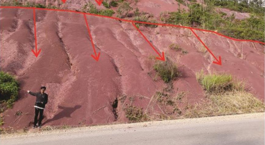
Research area is around Tanjung Balik, Koto Baru Sub Base, Lima Puluh Kota District, West Sumatra Province. Located along the highway Km 10-15 Riau – West Sumatra and the coordinate around 00˚08'40 '' LU - 0˚11'20 '' N and 100˚45'20 '' BT - 100˚47'00 '' BT. The purpose of research to identify petrography, microstructure, types of landslides and the geological condition. The methods using polarization microscope, stereography, landslide identification survey and geological mapping. The result of study shows the petrography analysis of lithology of study area are classified into three types of rocks are Feldspathic Greywacke, Lithic Arenite, and Slate. Microstructures trending system show the foliation structure that is relatively Southeast-Northwest. Types of landslide which dominates in the research area are debris avalanche and translational landslide. Geological analysis show some of rock units are classified into two units: Sandstone Unit and Slate Unit. Sandstone Unit spread in the northern part of the study area, while Slate Unit spread in the southern part of the study area. The characteristics of these rocks showed Pematang Formation.
Downloads
References
Anderson, S.P., Dietrich, W.E., Brimhall, G.H., 2002. Weathering profiles, mass-balance analysis, and rates of solute loss: Linkages between weathering and erosion in a small, steep catchment. Bull. Geol. Soc. Am. 114, 1143–1158. doi:10.1130/0016-7606(2002)114<1143:WPMBAA>2.0.CO
Aydin, A.L.İ., 2010. Application of the Normalized Full Gradient ( NFG ) Method to Resistivity Data 19, 513–526. doi:10.3906/yer-0903-2
Cahyaningsih, C., 2016. Hydrology Analysis and Rainwater Harversting Effectiveness as an Alternative to Face Water Crisis in Bantan Tua Village Bengkalis District-Riau. J. Dyn. 1, 27–30. doi:10.21063/JoD.2016.V1.1.27-30
Cahyaningsih, C., Ritonga, A.L., Aldila, S., Zulhikmah, Z., 2018. Lithofacies And Depositional Analysis Environment Of West Section Kolok Nan Tuo Village, Sawahlunto City, West Of Sumatera. J. Geosci. Eng. Environ. Technol. 3, 128. doi:10.24273/jgeet.2018.3.2.340
Catur Cahyaningsih, Arrachim Maulana Putera, Gayuh Pramukti, M.M.S., 2018. Geology and Geochemistry Analysis for Ki Index Calculation of Dompak Island Granite Bauxites to Determine the Economical Mineral. Springer Singapore. doi:10.1007/978-981-10-8471-3
Catur Cahyaningsih, Puja Fransismik Crensonni, D.B., 2018. Unicharacteristic of Geomorphological Landscape & Depositional Environment in Talawi Hilir : Geotourism Value of Sawahlunto 3, 42–51.
ÇelIk, H., 2013. The effects of linear coarse-grained slope channel bodies on the orientations of fold developments: A case study from the Middle Eocene-Lower Oligocene Ki{dotless}rkgeçit Formation,
Elazi{dotless}ǧ, eastern Turkey. Turkish J. Earth Sci. 22, 320–338. doi:10.3906/yer-1202-5
Chang, S., Wan, S., 2015. Geoscience Frontiers Discrete rough set analysis of two different soil-behavior-induced landslides in National Shei-Pa Park , Taiwan. Geosci. Front. 6, 807–816. doi:10.1016/j.gsf.2013.12.010
Choanji, T., Yuskar, Y., Putra, D.B.E., Cahyaningsih, C., Sakti, W., 2018. Clustering Slope Stability from Using Drone DEM Lineament Extraction And Rock Mass Rating In Pangkalan Koto Baru , West Sumatra , Indonesia J. Applied Geom. Inf. 2, 124–129.
Correns, C.W., Zemann, J., Koritnig, S., 1969. Introduction to Mineralogy, Crystallography and Petrology. doi:10.1007/978-3-662-28578-7
Crampin, S., Gao, Y., 2012. Plate-wide deformation before the Sumatra–Andaman Earthquake. J. Asian Earth Sci. 46, 61–69. doi:10.1016/j.jseaes.2011.10.015
De Coster, G.L., 1974. The Geology of the Central and South Sumatra Basins. Proc. Indones. Pet. Assoc. Third Annu. Conv. June 1974 77–110.
Dewandra Bagus Eka Putra, yuniarti yuskar, catur cahyaningsih, S.K., 2017. Title Rock Mass Classification System Using Rock Mass Rating (Rmr) Of A Cut Slope In Riau – West Sumatra Road. pp. 8–10.
Fatriadi, R., Asteriani, F., Cahyaningsih, C., 2017. Effectiveness of the National Program for Community Empowerment (PNPM) for Infrastructure Development Accelerated and Geoplanology in District of Marpoyan Damai, Pekanbaru. J. Geosci. Eng. Environ. Technol. 2, 53. doi:10.24273/jgeet.2017.2.1.30
Frost, B.R., Frost, C.D., n.d. IGNEOUS AND METAMORPHIC Essentials of Igneous and.
GEORGE, R.D., 1943. Minerals and Rocks, Soil Science. doi:10.1097/00010694-194311000-00011
Holis, Z., Sapiie, B., 2012. Fractured Basement Reservoirs Characterization in Central Sumatera Basin , Kotopanjang Area , Riau , Western Indonesia : an Outcrop Analog Study. Am. Assoc. Pet. Geol. Int. Conf. Exhib. Singapore 50735, 1–4.
Hughes, C.J., 1982. Igneous Petrology. Developments in Petrology 7.
Hungr, O., Leroueil, S., Picarelli, L., 2014. The Varnes classification of landslide types, an update. Landslides 11, 167–194. doi:10.1007/s10346-013-0436-y
Joseph E. Laing, B.P.A. and A.R., 1994. Structural evolution of the Pematang reservoirs, Kelabu-dingga Gas Fields, Sumatra. AAPG Int. Conf. Exhib.
Kumar, T., Negassa, L., Kala, P.M., 2015. RESEARCH PAPER GIS based Grid overlay method versus modeling approach – A comparative study for landslide hazard zonation ( LHZ ) in Meta Robi District of West Showa Zone in Ethiopia 235–250.
Mairizki, F., Cahyaningsih, C., 2016. Groundwater Quality Analysis in the Coastal of Bengkalis City. J. Dyn. 1.
Margottini, C., Canuti, P., Sassa, K., 2013. Landslide Science and Practice. Springer-Verlag Berlin Heidelberg.
Mennell, F.P., 1913. A Manual of Petrology.
Natalie, O., Bettis, E.A., Zaim, Y., Rizal, Y., Aswan, A., Gunnell, G.F., Zonneveld, J., Ciochon, R.L., 2015. Paleoenvironmental conditions in the late Paleogene, Sumatra, Indonesia Natalie. J. ASIAN EARTH Sci. doi:10.1016/j.jseaes.2015.06.025
Nlomngan, J.P.S., Ndzana, S.P.M., Pountougnigni, P.N., Fils, S.N., Penaye, J., 2013. THE INFLUENCE OF BREAKING TECTONICS ON THE STRUCTURAL GUIDANCE OF STREAM FLOWS IN THE NORTHERN-EQUATORIAL PAN-AFRICAN CHAIN : THE CASE OF THE MAKENENE REGION 2, 1–8.
Nugraha, H., Wacano, D., Arya, G., Cahyadi, A., 2015. Geomorphometric characteristics of landslides in the Tinalah Watershed , Menoreh Mountains , Yogyakarta , Indonesia. Procedia Environ. Sci. 28, 578–586. doi:10.1016/j.proenv.2015.07.068
Onyelowe, K.C., Okoafor, F.O., 2012. Geochemistry of Soil Stabilization. ARPN J. Earth Sci. ©2006-2012 Asian Res. Publ. Netw. (ARPN). ISSN 2305-493X 1, 32–35.
Samuel, M.A., Hartono, L., Banner, F.T., 1995. A new stratigraphy for the islands of the Sumatran Forearc , Indonesia.
Santoso, D., Suroso, A., Kombaitan, B., Setiawan, B., 2013. Exploring the use of risk assessment approach for climate change adaptation in Indonesia : Case study of flood risk and adaptation assessment in the South Sumatra province. Procedia Environ. Sci. 17, 372–381. doi:10.1016/j.proenv.2013.02.050
Sassa, K., Canuti, P., Yin, Y., Programme, T.I., 2014. Landslide Science for a Safer Geoenvironment. Springer International Publishing Switzerland.
Shah, A.A., 2015. Kashmir Basin Fault and its tectonic significance in NW Himalaya, Jammu and Kashmir, India. Int. J. Earth Sci. 104, 1901–1906. doi:10.1007/s00531-015-1183-1
Shah, A.A., 2013. Earthquake geology of Kashmir Basin and its implications for future large earthquakes. Int. J. Earth Sci. 102, 1957–1966. doi:10.1007/s00531-013-0874-8
Shanmugam, G., 2015. The landslide problem 4, 109–166. doi:10.3724/SP.J.1261.2015.00071
Sharma, S., Sengupta, S., Roy, I., 2015. Identification of Failure Surfaces in Dragline Dumps of Opencast Coal Mines 4, 43–53.
Stefanelli, C.T., Segoni, S., Casagli, N., Catani, F., 2016. Geomorphic indexing of landslide dams evolution. Eng. Geol. 208, 1–10. doi:10.1016/j.enggeo.2016.04.024
Taylor, F.E., Malamud, B.D., Freeborough, K., Demeritt, D., 2015. Geomorphology Enriching Great Britain ’ s National Landslide Database by searching newspaper archives 249, 52–68.
Umitsu, M., Tanavud, C., Patanakanog, B., 2007. Effects of landforms on tsunami f low in the plains of Banda Aceh , Indonesia , and Nam Khem , Thailand 242, 141–153. doi:10.1016/j.margeo.2006.10.030
Vinay, M., Mahalingam, B., 2015. Quantification of Soil Erosion By Water Using Gis and Remote Sensing Techniques : a Study of Pandavapura Taluk , Mandya District , Karnataka , India. ARPN J. Earth Sci. 4, 103–110.
Walsh, M.P.K., 2005. Pocket Nature Rocks and Minerals. Dorling Kindersley.
Widayat, A.H., van de Schootbrugge, B., Oschmann, W., Anggayana, K., Püttmann, W., 2016. Climatic control on primary productivity changes during development of the Late Eocene Kiliran Jao lake, Central Sumatra Basin, Indonesia. Int. J. Coal Geol. 165, 133–141. doi:10.1016/j.coal.2016.08.008
Xu, C., Xu, X., Shyu, J.B.H., 2015. Geomorphology Database and spatial distribution of landslides triggered by the Lushan , China Mw 6 . 6 earthquake of 20 April 2013 248, 77–92.
Yaman, B., KÖse, N., Akkemik, Ü., 2013. Changes in stem growth rates and root wood anatomy of oriental beech after a landslide event in Hanyeri, Bartin, Turkey. Turkish J. Agric. For. 37, 105–109. doi:10.3906/tar-1110-28
Yuskar, Y., Putra, D.B.E., Suryadi, A., Choanji, T., Cahyaningsih, C., 2017. Structural Geology Analysis In A Disaster-Prone Of Slope Failure, Merangin Village, Kuok District, Kampar Regency, Riau Province. J. Geosci. Eng. Environ. Technol. 2, 249–254. doi:10.24273/jgeet.2017.2.4.691.
Downloads
Published
Issue
Section
License
Copyright @2019. This is an open-access article distributed under the terms of the Creative Commons Attribution-ShareAlike 4.0 International License which permits unrestricted use, distribution, and reproduction in any medium. Copyrights of all materials published in JGEET are freely available without charge to users or / institution. Users are allowed to read, download, copy, distribute, search, or link to full-text articles in this journal without asking by giving appropriate credit, provide a link to the license, and indicate if changes were made. All of the remix, transform, or build upon the material must distribute the contributions under the same license as the original.