
Geological Structure Analysis to Determine the Direction of the Main Stress at Western Part of Kolok Mudik, Barangin District, Sawahlunto, West Sumatera
DOI:
https://doi.org/10.24273/jgeet.2017.2.1.20Keywords:
fault, fold, joint, stressAbstract
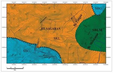
On the study area there are three types of structure, those are fault, fold and joint. Types of fault were found in the study area, reverse fault with the strike/dip is N215oE/75o, normal fault has a fault directions N22oE and N200oE with pitch 35o, and dextral fault with pitch 10o and strike N219oE. Fold and joint structures used to determine the direction of the main stress on the study area. Further, an analysis used stereonet for data folds and joints. So that from the data got three directions of main stress, those are Northeast – Southwest (T1), North – South (T2) and Southeast – Northwest (T3). On the Northeast – Southwest (T1) stress there are four geological structures, anticline fold at ST.3 , syncline folds at ST. 13a, ST. 13b, ST. 13c and ST. 33, chevron fold at ST. 44 and joint at ST. 2. On the North – South (T2) stress there are three geological structures, those are syncline fold at ST. 35, anticline fold at ST. 54 and joints at ST. 41, ST. 46 and ST. 47. On the Southeast – Northwest (T3) stress were also three geological structures, those are chevron fold at ST 42a, overturned fold at ST. 42b, syncline fold at ST. 42c and joints at ST. 5 and ST. 34.
Downloads
References
Basmoera, Z,. 2008. Peta Wilayah Kota Sawahlunto, Provinsi Sumatera Barat.
Berger, Byron R., Ayuso, Robert A., Wynn, Jeffrey C., dan Seal, Robert R., 2008, Preliminary Model of Porphyry Copper Deposits, Open – File Report 2008 – 1321 U.S. Geological Survey, Reston, Virginia.
Kausarian, H, J. T. S. Sumantyo, H. Kuze, K. Detri, G. F. Panggabean, 2016. Silica Sand Identification using ALOS PALSAR Full Polarimetry on The Northern Coastline of Rupat Island, Indonesia. International Journal on Advance Science, Engineering and Information Technology (IJASEIT). Vol. 6, No. 5, 568-573.
Kausarian. H., J. T. S. Sumantyo, H. Kuze, K. Detri, S. Wiyono, 2017, The Origin and Distribution of Silica Mineral On The Recent Surface of Rupat Island, Indonesia, ARPN Journal of Engineering and Applied Sciences. Vol. 12, No.4, February 2017, ISSN 1819-6608.
Koesomadinata, R.P., dan Matasak, T., 1981, Stratigraphy and Sedimentation Ombilin Basin Central Sumatra (West Sumatra Province), Proceedings Indonesian Petroleum Association 10th Annual Convetion, hal 217 – 249.
Putra, D.B.E., Choanji, T., 2016. Preliminary Analysis of Slope Stability in Kuok and Surrounding Areas. J. Geoscience, Engineering, Environment, and Technology 1, 41–44.
Prata, Rizky. 2011. Geologi Daerah Sikalang dan Sekitarnya Kecamatan Barangin Kotamadya Sawahlunto Provinsi Sumatera Barat. Bandung. hal 33 – 68.
Silitonga P.H. dan Kastowo., 1995, Peta Geologi Lembar Solok Sumatera, Peta Geologi bersistem Sumatera, PPPG, Bandung.
Situmorang, B., Yulihanto, B., Guntur, A., Himawan, R.S., dan Jacob T.G., 1991, Structural Basin Development of the Ombilin Basin, Proceedings Indonesian Petroleum Association 10th Annual Convetion, hal 217 – 249.
Suryadi, Adi. 2016. Fault Analysis to Determine Deformation History of Kubang Pasu Formation at South of UniMAP Stadium Hill, Ulu Pauh, Perlis, Malaysia. Journal Geology Engineering Environmental and Technology (JGEET), Pekanbaru, Riau. Vol. 1
Woodcock, N. H. dan Fischer, M. 1986.Strike-slip duplexes. J. Struct. Geol., vol. 8, p. 725 – 735, DOI: 10.1016/0191-8141(86)90021-0.
Van Bemmelen, R.W., 1949, The Geology of Indonesia vol. 1 A. Government Printing Office, The Hague, MartinusNijhoff, vol. 1 A Netherlands.
Downloads
Published
Issue
Section
License
Copyright @2019. This is an open-access article distributed under the terms of the Creative Commons Attribution-ShareAlike 4.0 International License which permits unrestricted use, distribution, and reproduction in any medium. Copyrights of all materials published in JGEET are freely available without charge to users or / institution. Users are allowed to read, download, copy, distribute, search, or link to full-text articles in this journal without asking by giving appropriate credit, provide a link to the license, and indicate if changes were made. All of the remix, transform, or build upon the material must distribute the contributions under the same license as the original.


