
Integrated Subsurface Analysis of Thickness and Density for Liquefaction Hazard: Case Study of South Cilacap Region, Indonesia.
DOI:
https://doi.org/10.25299/jgeet.2021.6.1.5892Keywords:
residual anomaly, physical properties, gravity acceleration, subsurface interpretationAbstract
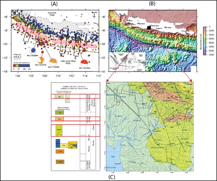
The thickness of the liquefable layer can be the factor inducing liquefaction hazard, apart from seismicity. Several studies have been conducted to predict the possibility of the liquefable layer based on the filed sampling. However, a detailed investigation of the subsurface interpretation has not been defined, in particular the thickness estimation of the liquefable layer. This study is carried out in south Cilacap area where potential liquefaction is exists due to the earthquake history data and near surface condition. The aim of this study is to investigate the physical properties and thickness distribution using GGMplus gravity data and resistivity data. This research is conducted by spectrum analysis of gravity model and 2D resistivity model . This study’s main results is by performing the residual gravity anomaly with the associated SRTM/DEM data to define the subsurface physical distribution and structural orientation of the area. Residual gravity anomaly is also separated through the low pass filter in order to have robust interpretation. The residual anomaly indicates that the area has identical structural pattern with geological and SRTM map. The results show a pattern of high gravity index in the northeast area of the study having range of 70 – 115 MGal gravity index, associated with the volcanic breccia, and a low gravity profile with less than 65 in the southwest, associated with the alluvial and water table dominated distribution. The thickness of Alluvial is determined by resistivity model with H1 at a range of 3 meters and H2 at a range of 4 m. This research is included in the potential liquefaction category with the potential for a large earthquake.
Downloads
References
Aditama, M. R. et al. (2019) ‘Structural framework and its compartmentalisation within the associated uncertainties: A case study from the Statfjord Reservoir, Northern North Sea’, in Journal of Physics: Conference Series.
Aditama, M. R., Saadi, A. G. and Nurcahya, B. E. (2020) ‘Investigasi Kerentanan Tanah Berpotensi Likuifikasi Menggunakan Metode Mikroseismik Di Wilayah Prambanan, Yogyakarta’, Dinamika Rekayasa.
Van Bemmelen, R. W. (1949) ‘The Geology of Indonesia. General Geology of Indonesia and Adjacent Archipelagoes’, Government Printing Office, The Hague.
Daud, Y. et al. (2019) ‘Resistivity characterization of the Arjuno-Welirang volcanic geothermal system (Indonesia) through 3-D Magnetotelluric inverse modeling’, Journal of Asian Earth Sciences.
FitzGerald, D. (2020) ‘Improved 3D Geology Modelling using an Implicit Function Interpolator and Forward Modelling of Potential Field Data’, in.
Gao, F., Chen, H. B. and Luo, Y. (2013) ‘3D Sediment Physical Model Test Study for PLTU 2 JATENG 1 × 660 MW Adipala, Cilacap, Indonesia’, in Springer Geology.
Guillen, A. et al. (2008) ‘Geological modelling from field data and geological knowledge. Part II. Modelling validation using gravity and magnetic data inversion’, Physics of the Earth and Planetary Interiors.
Hall, R. (2012) ‘Late Jurassic-Cenozoic reconstructions of the Indonesian region and the Indian Ocean’, Tectonophysics.
Hardy, T. et al. (2015) ‘KARAKTERISTIK LAPISAN TANAH BERPOTENSI LIKUIFAKSI BERDASARKAN RESISTIVITAS BATUAN DI DAERAH CILACAP’, Jurnal Meteorologi dan Geofisika.
Hirt, C. et al. (2013) ‘New ultrahigh-resolution picture of Earth’s gravity field’, Geophysical Research Letters.
Iswahyudi, S. et al. (2019) ‘KONTROL STRUKTUR GEOLOGI PADA KEMUNCULAN MATA AIR PANAS BUMI DAERAH SUBANG, JAWA BARAT’, Jurnal Geosaintek.
Jinguuji, M. and Toprak, S. (2017) ‘A case study of liquefaction risk analysis based on the thickness and depth of the liquefaction layer using CPT and electric resistivity data in the Hinode area, Itako City, Ibaraki Prefecture, Japan’, Exploration Geophysics.
Masson, F. et al. (2012) ‘Lithospheric structure of Taiwan from gravity modelling and sequential inversion of seismological and gravity data’, Tectonophysics.
Muhaimin, M., Tjahjono, B. and Darmawan, D. (2016) ‘ANALISIS RISIKO GEMPABUMI DI CILACAP PROVINSI JAWA TENGAH’, Jurnal Ilmu Tanah dan Lingkungan.
Nakata, N. and Snieder, R. (2014) ‘Monitoring a building using deconvolution interferometry. II: Ambient-vibration analysis’, Bulletin of the Seismological Society of America.
Ozcep, F. and Ozcep, T. (2011) ‘Geophysical analysis of the soils for civil (geotechnical) engineering and urban planning purposes: Some case histories from Turkey’, International Journal of Physical Sciences.
Pokhrel, R. M., Kuwano, J. and Tachibana, S. (2013) ‘A kriging method of interpolation used to map liquefaction potential over alluvial ground’, Engineering Geology.
Suwarno, Sutomo and Aditama, M. R. (2019) ‘The analysis of the landslide vulnerability sub watersheds arus in banyumas regency’, Geographia Technica, 14(2).
Tini, T., Tohari, A. and Iryanti, M. (2017) ‘Analisis Potensi Likuifaksi Akibat Gempa Bumi Menggunakan Metode SPT (Standar Penetration Test) Dan Cpt (Cone Penetration Test) Di Kabupaten Bantul, Yogyakarta’, Wahana Fisika.
Widiyantoro, S. et al. (2020) ‘Implications for megathrust earthquakes and tsunamis from seismic gaps south of Java Indonesia’, Scientific Reports.
Zeng, H., Xu, D. and Tan, H. (2007) ‘A model study for estimating optimum upward-continuation height for gravity separation with application to a Bouguer gravity anomaly over a mineral deposit, Jilin province, northeast China’, Geophysics.
Downloads
Published
Issue
Section
License
Copyright @2019. This is an open-access article distributed under the terms of the Creative Commons Attribution-ShareAlike 4.0 International License which permits unrestricted use, distribution, and reproduction in any medium. Copyrights of all materials published in JGEET are freely available without charge to users or / institution. Users are allowed to read, download, copy, distribute, search, or link to full-text articles in this journal without asking by giving appropriate credit, provide a link to the license, and indicate if changes were made. All of the remix, transform, or build upon the material must distribute the contributions under the same license as the original.


