
Analysis of the Surface Subsidence of Porong and Surrounding Area, East Java, Indonesia based on Interferometric Satellite Aperture Radar (InSAR) Data.
DOI:
https://doi.org/10.25299/jgeet.2020.5.4.5149Keywords:
surface subsidence, InSAR, Porong, East JavaAbstract
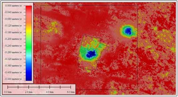
Since 2006, the mud volcano erupted in the Porong area due to wellbore failure triggered by an earthquake (2006) epicenter in the Jogjakarta area. The mud volcano buried several villages with mud and continued erupted until today. Based on the InSAR data, it can be seen that the subsidence is still happening near the dam area and another area that is not related to mud volcano eruption such as the production of two gas fields in the Porong area. Moreover, the Porong area is flat and low, less than 4 meters above sea level. The analysis shows that the subsidence rate in this area is up to 0.5 m/yr. If this subsidence is continuing, the city can be sinking and flooding during the rainy season. The prediction result from this method is about 10 years more and 36 years since in 2006 based on the mudflow rate method.
Downloads
References
Abidin H.Z., Kusuma M.A., Andreas H., Gamal M., and Sumintadireja P., 2008. GPS-Based Monitoring of Surface Displacements in the Mud Volcano Area, Sidoarjo, East Java. Observing our Changing Earth: Proceedings of the 2007 IAG General Assembly, Perugia, Italy, July 2 - 13, 2007.
Berardino, P., G. Fornaro, R. Lanari, and E. Sansosti., 2002. “A New Algorithm for SurfaceDeformation Monitoring Based on Small Baseline DifferentialSAR Interferograms.” IEEE Transactions on Geoscience and Remote Sensing 40 (11): 2375–2383.
Davies., R.J., Mathias S.A., Swarbrick R.E., and Tingay M.J., 2011. Probabilistic longevity estimates for the LUSI mud volcano, East Java. Journal of the Geological Society, London, Vol. 168, 2011, pp. 517–523.
Deguchi, T., Y. Maruyama, and C. Kobayashi., 2007. Monitoring of Deformation Caused by the Development of Oil and Gas Field Using PALSAR and ASTER Data, Powerpoint presentation file, 14 January, ERSDAC (Earth Remote Sensing Data Analysis Center), Japan.
Istadi B.P., Pramono G.H., Sumintadireja P., and Alam S., 2009. Modeling study of growth and potential geohazard for LUSI mud volcano: East Java, Indonesia. Marine and Petroleum Geology 26 (2009) 1724-1739.
Istadi B.P., Wibowo H.T., Sunardi E., Hadi S., and Sawolo N., 2012. Mud Volcano and Its Evolution. Earth Science book chapter, Intech Open.
Just, D., and R. Bamler. 1994. “Phase Statistics of Interferograms with Applications to SyntheticAperture Radar.” Applied Optics 33 (20): 4361–4368.
Sawolo N., Sutriono E., Istadi B.P., Darmoyo A.B., 2010. Was LUSI caused by drilling? – Authors reply to discussion. Marine and Petroleum Geology 27 (2010), 1658-1575.
Schiller, D.M., Seubert, B.W., Musliki, S., Abdullah, M., 1994. The reservoirpotential of globigerinid sands in Indonesia. In: Proceedings of the 23rdAnnual Convention, Proceedings of the Indonesian Petroleum Association,vol. 1, p. 189ff.
Schmidt, D. A., and R. Burgmann. 2003. “Time-Dependent Land Uplift and Subsidence in theSanta Clara Valley, California, from a Large Interferometric Synthetic Aperture Radar Data Set.”Journal of Geophysical Research 108 (B9): 2416–2428.
Shirzae M., Rudolph M.L., and Manga M., 2015. Deep and shallow sources for the Lusi mud eruption revealed by surface deformation. Geophys. Res. Lett., 42, 5274–5281.
Willumsen, P. and Schiller, D.M., 1994. High quality volcaniclastic sandstone reservoirsin East Java, Indonesia. In: 23rd Annual Convention, vol. I. IPA, pp. 101–111.
Downloads
Published
Issue
Section
License
Copyright @2019. This is an open-access article distributed under the terms of the Creative Commons Attribution-ShareAlike 4.0 International License which permits unrestricted use, distribution, and reproduction in any medium. Copyrights of all materials published in JGEET are freely available without charge to users or / institution. Users are allowed to read, download, copy, distribute, search, or link to full-text articles in this journal without asking by giving appropriate credit, provide a link to the license, and indicate if changes were made. All of the remix, transform, or build upon the material must distribute the contributions under the same license as the original.


