
Geo-Environment Aspects Assessment Applied In Land Stability Determination Of A Disaster-Prone Area: A Case Study Around The Lembang Active Fault Zone, On The Western Part Of Bandung Basin, Indonesia
DOI:
https://doi.org/10.25299/jgeet.2024.9.3.18062Keywords:
Geo-environment aspects, Land stability, Stable area, Moderate area, Unstable area, Disaster-prone areaAbstract
Rainfall, landforms, lithology or soil characteristics, and geological structures are geo-environment aspects that might be used to assess stability of the land in a disaster-prone area, e.g. in a case of study around the Lembang active fault zone of the western part of Bandung Basin, Indonesia.
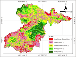
In this study, such geo-environment aspects were weighted and scored constantly in five class of value and importance, due to its influence on the land stability. After this scoring method applied, firstly, a land capability of the research area in relation to disaster potential will be recognized and used to analyze its land stability.
According to such analyses, the study area can be divided into two zones of land stability, i.e. (i) moderate area which dominates the research area, and (ii) non-stable or unstable area near Lembang active fault zone. The dominant moderate and unstable area show that the fault zone has still widely affected the surroundings landscape and its physical characteristics. In fact, the current evaluation of existing landuse show that the development has been carried out intensively on these areas. It indicates that the development of the area is contituted as a high risk activity. Therefore, in this case, a good spatial planning or an environmental good governance must be applied appropriately in such disaster-prone area.
Downloads
References
Atapour, H., & Aftabi, A. 2002. Geomorphological, geochemical and geo-environmental aspects of karstification in the urban areas of Kerman city, southeastern, Iran. Environmental Geology, 42(7), 783–792.
Bell, F. G., Cripps, J. C., Culshaw, M. G., & O’hara, M. 1987. Aspects of geology in planning.
Buttrick, D. B., Van Rooy, J. L., and Ligthelm, R. 1993. Environmental geological aspects of the dolomites of South Africa. Journal of African Earth Sciences (and the Middle East), 16(1-2), 53-61.
Catanese and Snyder, 1992. Pengantar Perencanaan Kota. Erlangga, Jakarta, Indonesia.
Conyers, Diana and Hills, Peter. 1990. An Introduction to Development Planning in The Third Word. John Wiley and Sons. New York, USA.
Geremia, F., Bentivenga, M., & Palladino, G. 2015. Environmental geology applied to geoconservation in the interaction between geosites and linear infrastructures in South-Eastern Italy. Geoheritage, 7(1), 33–46.
Golany, Gideon. 1976, New Town Planning, Principles and Practice. John Wiley and Son, New York, USA.
Henry, C. D., and Basciano, J. M. 1979. Environmental geology of the Wilcox Group lignite belt, East Texas (No. NP-4901164). Texas Univ., Austin (USA). Bureau of Economic Geology.
Hidayatillah, A. S., Nurcahyo, T. A., Muliawan, J. B. P., & Endarsih, A. E. 2024. Identifying Dominant Structural Pattern of Semarang City Using Digital Elevation Model and Landsat 8-OLI Imagery. Journal of Geoscience, Engineering, Environment, and Technology, 9(1), 28–37.
Howard, Arthur D. and Irwin Remson. 1978. Geology in Environmental Planning. McGraw-Hill. New York, USA.
Karwan, K. R., and Wallace, W. A. 1984. Can We Manage Natural Hazards? [Review of Evacuation Planning in Emergency Management; Social Science and Natural Nazards; Natural Hazard Risk Assessment and Public Policy: Anticipating the Unexpected, by R. W. Perry, M. K. Lindell, M. R. Greene, J. D. Wright, P. H. Rossi, W. J. Petak, and A. A. Atkinson]. Public Administration Review, 44(2), 177–181.
Kivell, P. 2002. Land and the city: patterns and processes of urban change. Routledge, London, UK. 238 p.
Koesmono, K., and Suwarna, N. 1996. Peta Geologi Lembar Sindangbarang, Jawa, Skala 1 : 100.000, Pusat Penelitian dan Pengembangan Geologi, Bandung, Indonesia.
Legget, R. F., 1973, Cities and geology, McGraw-Hill, New York, USA. 624 p.
Luthfianihuda, A., Neman, R. R. C., Iskandarsyah, T. Y. W. M., and Suganda, B. R. 2017. Environmental geological recommendation for urban development of Pidie and Pidie Jaya District, Nangroe Aceh Darussalam Province. In Proceedings of the 2nd Join Conference of Utsunomiya University and Universitas Padjadjaran, Nov. 24, 2017 (pp. 213-219).
Marsh, W. M. 1978. Environmental Analysis fof Land Use and Site Planning. Mc Graw-Hill Inc., New York, USA.
Nugraha, A. D., Supendi, P., Prabowo, B. S., Rosalia, S., Erlangga, Husni, Y. M., Widiyantoro, S., Puspito, N. T., & Priyono, A. 2019. The Recent Small Earthquakes around Lembang Fault, West Java, Bandung, Indonesia. Journal of Physics: Conference Series, 1204(1).
Oktariadi, O. 2009. Penentuan Peringkat Bahaya Tsunami dengan Metode Analytical Hierarchy Process (Studi kasus: Wilayah Pesisir Kabupaten Sukabumi). In Jurnal Geologi Indonesia (Vol. 4, Issue Juni).
Putri, R. F., Abadi, A. W., & Tastian, N. F. 2020. Impacts of Population Density for Landuse Assessment in Cengkareng, West Jakarta. Journal of Geoscience, Engineering, Environment, and Technology, 5(2), 56–67.
Sanny, T. A. 2017. Identification of Lembang fault, West-Java Indonesia by using controlled source audio-magnetotelluric (CSAMT). AIP Conference Proceedings, 1861.
Silitonga, H. P. 1973. Peta Geologi Lembar Bandung, Djawa, Skala 1 : 100.000. Direktorat Geologi, Bandung, Indonesia.
Steiner, F., Mcsherry, L., & Cohen, J. (n.d.). Land suitability analysis for the upper Gila River watershed.
Sudjatmiko. 1972. Peta Geologi Lembar Cianjur, Djawa, Skala 1 : 100.000. Direktorat Geologi, Bandung, Indonesia.
Supendi, P., Nugraha, A. D., Puspito, N. T., Widiyantoro, S., & Daryono, D. 2018. Identification of active faults in West Java, Indonesia, based on earthquake hypocenter determination, relocation, and focal mechanism analysis. Geoscience Letters, 5(1).
Tempiem, P., & Silapunt, R. 2021. Spreading Factor Allocation using the Standard Deviation Classification Method.
Usman, D. N., Sukarsih, I., Permanasari, Y., Mildani, D., Widayati, S., Nuryahya, H., Pulungan, L., & Ramadhani, R. N. 2023. Analysis of Disaster Vulnerability Areas in West Bandung Regency, West Java, Indonesia. Journal of Geoscience, Engineering, Environment, and Technology, 8(4), 305–311.
Van Zuidam, R. A. 1985. Aerial Photo-Interpretation in Terrain Analysis and Geomorphologic Mapping. Enschede: Smith Publishers.
Van Bemmelen, R. W., 1949, The Geology of Indonesia (Vol 1A) : General Geology, Martinus Nijhof, The Hague.
Wallace, C. S., & Boulton, D. M. 1968. An information measure for classification.
Wirosoedarmo, R., Bambang Rahadi Widiatmono, J., Widyoseno Jurusan Keteknikan Pertanian, Y., Teknologi Pertanian, F., & Brawijaya Jl Veteran Malang, U. (2014). Rencana Tata Ruang Wilayah (RTRW) Berdasarkan Daya Dukung Lingkungan Berbasis Kemampuan Lahan RTRW Arrangement Based on Environmental Supportability Based on Land Capability. In AGRITECH (Vol. 34, Issue 4).
Xu, K., Kong, C., Li, J., Zhang, L., and Wu, C. 2011. Suitability evaluation of urban construction land based on geo-environmental factors of Hangzhou, China. Computers & Geosciences, 37(8), 992-1002.
Downloads
Published
Issue
Section
License
Copyright (c) 2024 Journal of Geoscience, Engineering, Environment, and Technology

This work is licensed under a Creative Commons Attribution-ShareAlike 4.0 International License.
Copyright @2019. This is an open-access article distributed under the terms of the Creative Commons Attribution-ShareAlike 4.0 International License which permits unrestricted use, distribution, and reproduction in any medium. Copyrights of all materials published in JGEET are freely available without charge to users or / institution. Users are allowed to read, download, copy, distribute, search, or link to full-text articles in this journal without asking by giving appropriate credit, provide a link to the license, and indicate if changes were made. All of the remix, transform, or build upon the material must distribute the contributions under the same license as the original.


