
Mapping the Depth of Groundwater Level and Soil Permeability Based on Geographic Information Systems (GIS) for The Feasibility of Absorption Well Locations in The Application of Ecodrain in Tuah Madani District
DOI:
https://doi.org/10.25299/jgeet.2024.9.1.14036Keywords:
Groundwater Level Elevation, Soil Permeability, Geographic Information System, EcodrainAbstract
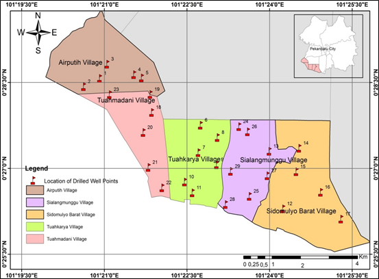
The problem of flooding in Tuah Madani District, Pekanbaru City, needs attention. Drainage and flood control systems need to be made to accommodate excess water and hold water somewhere. Groundwater management is directed at creating a balance between groundwater utilization and soil conservation efforts through the application of ecodrain which affects the conditions and characteristics of the area which provides an overview of land hydrology in parcels by comparing the height of the land with the receiving water bodies. as a drainage outlet. This research aims to create a map of groundwater depth and soil permeability based on Geographic Information Systems (GIS) for the feasibility of infiltration well locations in Tuah Madani District in implementing ecodrain. The research method was carried out by collecting data on the coordinates of infiltration wells at 30 points in five areas of Tuah Madani District. then measure the depth of the groundwater table and test the permeability in the field. Data is processed using ArcGIS. The results of mapping the depth of the groundwater table in the area are classified as shallow (1.28m–3.58m). Only 4 locations (Tuah Karya and West Sidomulyo) out of 30 sample locations did not meet the standards. Meanwhile, the permability value obtained was 2.61–11.07 cm/hour. Technically, the procedure for planning infiltration wells (SNI03-2453-2002) fulfills two conditions, namely a minimum groundwater depth of 1.50 m and soil permeability ≥ 2.0 cm/hour. Based on the contour lines of Tuah Madani District, it displays a pattern of groundwater flow from high flow to low flow at each point of the wellbore, the highest points on the map are colored blue (Air Putih and Sidomulyo Barat), while the lowest points on the map are Air Putih and Sidomulyo Barat. red (Tuah Madani, Luah Karya and Sialangmunggu).
Downloads
References
Adeyeye, O.A., Ikpokonte, E.A., Arabi, S.A., 2019. GIS-based groundwater potential mapping within Dengi area, North Central Nigeria. Egypt. J. Remote Sens. Sp. Sci. 22, 175–181.
Arun, P. V., 2013. A comparative analysis of different DEM interpolation methods. Egypt. J. Remote Sens. Sp. Sci. 16, 133–139.
Audah, S., 2018. Utilization of Satellite Landsat-8 Operational Land Imager (OLI) for Land Cover Classification Nutmeg Plantation In Tapaktuan Sub-District. J. Inotera 3, 23.
Audah, S., Nazliyati, N., Bakruddin, B., Saputra, E., Wathan, S., Rizky, M.M., 2019. Visual Analysis of Satellite Landsat Images Multitemporal and GPS as a Geographic Information System for Mapping of Nugmet Plantations in Tapaktuan. IOP Conf. Ser. Mater. Sci. Eng. 506.
Cotterill, S., Bracken, L.J., 2020. Assessing the effectiveness of sustainable drainage systems (SuDS): Interventions, impacts and challenges. Water (Switzerland) 12, 1–21.
Fan, Y., Miguez-Macho, G., Weaver, C.P., Walko, R., Robock, A., 2007. Incorporating water table dynamics in climate modeling: 1. Water table observations and equilibrium water table simulations. J. Geophys. Res. Atmos. 112.
Gleeson, T., Smith, L., Moosdorf, N., Hartmann, J., Dürr, H.H., Manning, A.H., Van Beek, L.P.H., Jellinek, A.M., 2011. Mapping permeability over the surface of the Earth. Geophys. Res. Lett. 38, 1–6.
Habibi, M., Fatimah, E., Azmeri, 2017. Strategi Penerapan Eko-Drainase Di Kawasan Gampoeng Keuramat Banda Aceh. J. Tek. Sipil 6, 309–316.
Hamuna, Baigo, M.A.P. et al, 2018. Sistem aliran dan potensi airtanah di sebagian Desa Sembangun ditinjau dari aspek kuantitas dan kualitas. Maj. Geogr. Indones. 32, 115.
Irvandi, M.A., Siswoyo, H., Irawan, D.E., 2022. Pemetaan Pola Aliran Air Tanah di Sekitar Kali Sumpil Kota Malang sama lain. TECNOSCIENZA 6, 389–403.
Joleha, Bochari, Malik, A., Suprasman, Elianora, 2023. Adaptasi Perubahan Iklim Melalui Penerapan Drainase Berwawasan Lingkungan ( Eco Drain ). J. Serambi Eng. VIII, 4564–4571.
Maxwell, R.M., Kollet, S.J., 2008. Interdependence of groundwater dynamics and land-energy feedbacks under climate change. Nat. Geosci. 1, 665–669.
Mulianto, B., 2018. Implementasi Peraturan Daerah Nomor 10 Tahun 2006 Tentang Sumber Daya Air Dan Sumur Resapan di Kecamatan Tampan Kota Pekanbaru.
Nobrega, E.P.R.R.S., Filho, F.M. de O., 2014. The Open Access Electronic Journal of the International Association for Environmental Hydrology. J. Environ. Hydrol. 22, 1–12.
Rahmadi, G., Suprayogi, I., Joleha, J., 2021. Analisa sumur resapan untuk mereduksi limpasan permukaan pada Perumahan Hang Tuah Cipta Residence Pekanbaru. J. Zona. 5, 66–76.
Rusdi, M., Roosli, R., Ahamad, M.S.S., 2015. Land evaluation suitability for settlement based on soil permeability, topography and geology ten years after tsunami in Banda Aceh, Indonesia. Egypt. J. Remote Sens. Sp. Sci. 18, 207–215.
Saldenela; Sutikno.S; Hendri, A., 2015. Pemetaan Pola Aliran Air Tanah Berbasis Sistem Informasi. J. online Mhs. Fak. Tek. 2, 1–8.
Setiawan, A., Wirahman W., L., Salehudin, Suroso, A., Saidah, H., 2023. Pemetaan dan kelayakan lokasi sumur resapan di mataram serta analisis efektifitas dalam mengurangi banjir yang berwawasan lingkungan. Pros. SAINTEK LPPM Univ. Mataram 5, 1–12.
Solomon, S., Quiel, F., 2006. Groundwater study using remote sensing and geographic information systems (GIS) in the central highlands of Eritrea. Hydrogeol. J. 14, 729–741.
Suwarsito, S., 2020. Kajian Pola Aliran Air Tanah Di Area Kampus Utama Universitas Muhammadiyah Purwokerto. Sainteks 17, 19.
York, J.P., Person, M., Gutowski, W.J., Winter, T.C., 2002. Putting aquifers into atmospheric simulation models: An example from the Mill Creek Watershed, Northeastern Kansas. Adv. Water Resour. 25, 221–238.
Downloads
Published
Issue
Section
License
Copyright (c) 2024 Journal of Geoscience, Engineering, Environment, and Technology

This work is licensed under a Creative Commons Attribution-ShareAlike 4.0 International License.
Copyright @2019. This is an open-access article distributed under the terms of the Creative Commons Attribution-ShareAlike 4.0 International License which permits unrestricted use, distribution, and reproduction in any medium. Copyrights of all materials published in JGEET are freely available without charge to users or / institution. Users are allowed to read, download, copy, distribute, search, or link to full-text articles in this journal without asking by giving appropriate credit, provide a link to the license, and indicate if changes were made. All of the remix, transform, or build upon the material must distribute the contributions under the same license as the original.


