Assessment of Geothermal Potentials In Some Parts of Upper Benue Trough Northeast Nigeria Using Aeromagnetic Data
DOI:
https://doi.org/10.25299/jgeet.2019.4.1.2090Keywords:
Aeromagnetic data, Curie point, geothermal gradient, heat flowAbstract
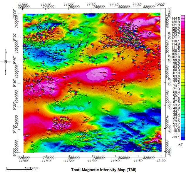
The assessment of geothermal potentials over part of the upper Benue trough corresponding to Kaltungo, Guyok, Lau and Dong areas, North Eastern Nigeria using spectral depth analysis of aeromagnetic data has been carried out. The study area is bounded by latitudes 9o00’N and 10o00’N and longitudes 11o00’E and 12o00’E. This research work is necessitated by the need for renewable and alternative sources of energy for use in Nigeria. Regional/residual separation was carried out on the total magnetic field using polynomial fitting method of order one. The residual map was divided into nine overlapping blocks for the spectral analysis. The centroid depths and depth to top of basement were obtained from the plot of log of power spectrum against wavenumber. These two parameters were used to estimate the Curie point depth using , where and are Curie depth, centroid depth and depth to top of basement respectively. The results from the spectral analysis suggested that in the parts of the Upper Benue trough, the basement is deepest at the south western portion towards the Lau area and varies between 0.55 and 3.8 km, while the centroid depth varies from 7.26 to 18.00 km. From the same portion of the trough, the Curie-point depths vary between 12.43 and 33.91 km and the corresponding geothermal gradient and heat flow values varying from 17.10 to 46.66 0C/km with an average of 30.75 0C/km and 42.75 to 116.65 mW/m2 with an average of 75.91 mW/m2 respectively. The maximum heat flow is found around the south western portion of the study area (Lau). The entire study area with high heat flow values might probably be good sources for geothermal and thereby recommended for both geothermal exploration and exploitation.
Downloads
References
Bansal, A.R., Gabriel, G., and Dimri, V.P., 2010. Power law distribution of susceptibility and density and its relation to seismic properties: An example from the German continental deep drilling program. J. Appl. Geophys. 72, 123–128.
Bansal, A.R., Gabriel, G., Dimri, V.P., and Krawczyk, C.M., 2011. Estimation of depth to the bottom of magnetic sources by a modified centroid method for fractal distribution of sources: An application to aeromagnetic data in Germany. Geophysics 76, 11–22.
Bhattacharryya, B.K., Leu, L.K., 1975. Spectral analysis of gravity and magnetic anomalies of two dimensional structures. Geophysics 40, 993–1031.
Carter, J., Barber, W., Tait, E.A., and Jones, G.P., 1963. The geology of parts of Adamawa, Bauchi and Borno provinces in northeastern Nigeria. Geol. Surv. Niger. Bull. 30, 1–108.
Chinwuko, A.I., Onwuemesi, A.G., Anakwuba, E.K., Onuba, L.O., and Nwokeabia, N.C., 2012. Interpretation of aeromagnetic anomalies over parts of upper Benue trough and Southern Chad Basin, Nigeria. Adv. Appl. Sci. Res. 3, 1757–1766.
Nagata, T., 1961. Rock magnetism, Maruzen, Tokyo. Nnange, J. Mining, Poudjom Djomani 350.
Nur, A., Ofeogbu, C.O., and Onuoha, K.M., 1999. Estimation of the depth to the Curie point isotherm in the upper Benue trough, Nigeria. J. Min. Geol. 35.
Nwankwo, L.I., Olasehinde, P.I., and Akoshile, C.O., 2011. Heat flow anomalies from the spectral analysis of airborne magnetic data of Nupe Basin, Nigeria. Asian J. Earth Sci. 1, 1–6.
Nwankwo, L.I., Sunday, A.J., 2017. Regional estimation of curie-point depths and succeeding geothermal parameters from recently acquired high-resolution aeromagnetic data of the entire Bida basin, north-central Nigeria. Geotherm. energy Sci. 1, 9.
Obaje, N.G., 2009. Geology and mineral resources of Nigeria. Springer, Dordrecht Heidelberg London New York.
Onuba, L.N., Onwuemesi, A.G., Anudu, G.K., Chiaghanam, O.I., Ifelunni, C.D., 2008. Interpretation of aeromagnetic anomalies over upper Benue trough, Northeastern Nigeria. Nat. Appl. Sci. J. 9.
Osazuwa, I.B., Ajakaiye, D.E., and Verheijen, P.J.T., 1981. Analysis of the structure of part of the upper Benue rift valley on the basis of new geophysical data. Earth evolution. Sciences (New. York). 2, 126–133.
Spector, A., Grant, F.E., 1970. Statistical models for interpreting aeromagnetic data, Geophysics.
Sunmonu, L.A., Adabanija, M.A., 2000. 2-Dimensional spectra analysis of magnetic anomalies of Southeastern part of Middle-Niger Basin, Central Nigeria. Niger. J. Phys. 12, 39–43.
Tanaka, A., Okubo, Y., and Matsubayashi, O., 1999. Curie point depth based on spectrum analysis of the magnetic anomaly data in East and Southeast Asia. Tectonophysics 306, 461–470.
Tiwari, G.N., Ghosal, M.K., 2005. Renewable energy resources: Basic principles and applications, in: Alpha Science International. p. 49.
Tselentis, G.A., 1991. An attempt to define curie depth in Greece from aeromagnetic and heat flow data. PAGEOPH 136, 87–101.
Zaborski, P., Ugodulunwa, F., Idornigie, A., Nnabo, P., and Ibe, K., 2014. Stratigraphy, structure of the cretaceous Gongola Basin, Northeastern Nigeria. Bull. Cent. Res. Prod. Elf Aquitatine 22, 153–185.
Downloads
Published
Issue
Section
License
Copyright @2019. This is an open-access article distributed under the terms of the Creative Commons Attribution-ShareAlike 4.0 International License which permits unrestricted use, distribution, and reproduction in any medium. Copyrights of all materials published in JGEET are freely available without charge to users or / institution. Users are allowed to read, download, copy, distribute, search, or link to full-text articles in this journal without asking by giving appropriate credit, provide a link to the license, and indicate if changes were made. All of the remix, transform, or build upon the material must distribute the contributions under the same license as the original.