
Assessment of the Leachate Contamination Level of Groundwater Resource at a Dumpsite, In Minna, North Central, Nigeria Using Resistivity Method
DOI:
https://doi.org/10.25299/jgeet.2019.4.2.2159Keywords:
Contaminant, Dumpsite, Electrical Resistivity, Leachate, PlumesAbstract
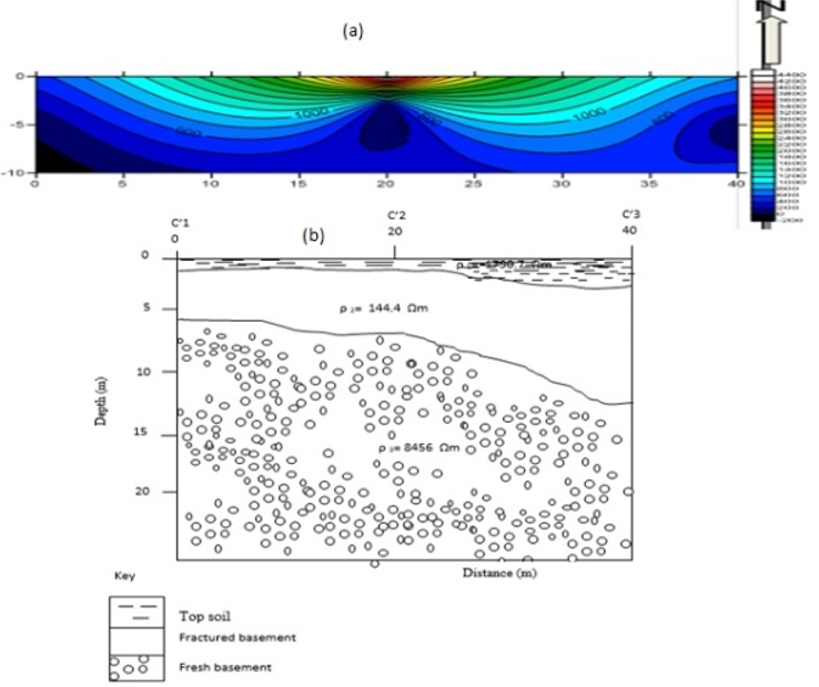
This research work focused on the use of direct current resistivity method to analyse data collected from refuse dumpsite at eastern bye pass Minna. The study area lies approximately on longitude 60 36’19.84”E to 6036’23.15”E and latitude 90 38’04.97”N to 9038’08.25”N, with a dimension of 100m x 100m within the basement complex of north central Nigeria. Vertical Electrical Sounding was carried out on the dumpsite with the aim of delineating the leachate contaminant plumes using resistivity method. Nine electrical resistivity profiles were measured on the site. Six transverse profiles were conducted on the dumpsite with thirty-six vertical electrical sounding (VES) point, three transverse profiles was also conducted on the control site which is 100 meters away from the dumpsite having nine vertical electrical sounding (VES) point and a dimension of 40m x 40m. The resistivity data obtained was analyzed using winresist software. The data obtained from the study area revealed three underlain layer they are the topsoil, fractured basement and fresh basement. The dumpsite was typified by A-types and H-types of curve and the control site was typified by H-type of curves. Iso–resistivity maps at various depths were observed, at the surface, 3m, 5m,7m, and 10m for the dumpsite and the control site. It can therefore be inferred from this study that the depth of contamination is 7 meter and aquifer found within this depth are most likely to be contaminated by leachate and water bearing formation beyond the depth of 7m is safe from contamination. The rate of contamination of the study area is approximately 1.0 meter per year.
Downloads
References
Jatau, B. S., & Ajodo, R. O. (2006). Preliminary Geo-environment evaluation of part of Kaduna North Metropolis, Kaduna, Nigeria. A Paper presented at Nigeria Association of Hydrogeologists (NAH) 18th Annual National Conference Asaba, 1-2.
Obaje N.G (2009). Geology and Mineral Resources of Nigeria.Springer Dordrecht Heidelberg London New York pg. 13-19.
Omolayo, D., & Fatoba, J.T. (2014). 2D Electrical Imaging Surveys For Leachate Plume Migration At An Old Dumpsite In Ibadan South Western Nigeria. International Journal. Geophysics, 530, 1 – 6.
Rahaman, M.A., & Ocan O. (1978). Reletionships in Precambrian Migmatite Gneissess of Nigeria. Nigeria Journal mineral geology. 15, 23 – 32.
Soupios, P. Papadopoulo, S. I, Kouli, .M, Georgaki, I, Vallianatos, F &Kokkinous, E. (2006). Environmental Geology 7, 418
Downloads
Published
Issue
Section
License
Copyright @2019. This is an open-access article distributed under the terms of the Creative Commons Attribution-ShareAlike 4.0 International License which permits unrestricted use, distribution, and reproduction in any medium. Copyrights of all materials published in JGEET are freely available without charge to users or / institution. Users are allowed to read, download, copy, distribute, search, or link to full-text articles in this journal without asking by giving appropriate credit, provide a link to the license, and indicate if changes were made. All of the remix, transform, or build upon the material must distribute the contributions under the same license as the original.


