
Uniqueness Deposit of Sediment on Floodplain Resulting From Lateral Accretion on Tropical Area : Study Case at Kampar River, Indonesia
DOI:
https://doi.org/10.24273/jgeet.2017.2.1.12Keywords:
Kampar Rivers, lateral accretion, floodplain, meandering, depositional modelAbstract
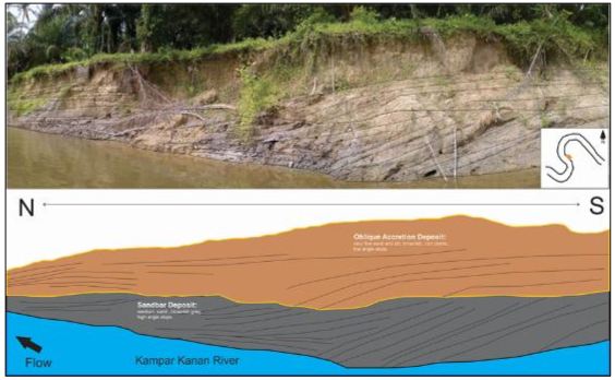
Kampar rivers has a length of 413 km with average depth of 7.7 m and width of 143 m. Sixty percent of this rivers are meandering fluvial system which transport and deposit a mixture of suspended and bed-load (mixed load) along low energy. River channel that moving sideways by erosion is undergoing lateral migration and the top of the point bar becomes the edge of the floodplain and the fining-upward succession of the point bar will be capped by overbank deposits of Kampar River. Along the Kampar Rivers, there are more than 60% of floodplain sediments and almost all of the floodplain formed by bend migration on the suspended-load channels of Kampar watershed. This formation consist of succession of fine to medium sand and silt/mud, with root traces, that form as drapes on the prograding bank. These beds dip mostly channel wards and quickly wedge out as they grade up and onto the floodplain. The depositional model is presented showing how lateral accretion can make a significant contribution to the preservation of fine-grained within channel deposits in contemporary floodplains. The examples presented here demonstrate that analogues to ancient point-bar deposits containing alternating sandstone and shale sequences are common in the low-energy fluvial environments of Riau rivers especially Kampar rivers.
Downloads
References
Belmont, P., 2011. Floodplain width adjustments in response to rapid base level fall and knickpoint migration. Geomorphology 128, 92–102.
Boggs, S., 2005. Principles of Sedimentology and Stratigraphy (4th Edition). Prentice Hall.
Bridge, J.S., 2003. Rivers and Floodplains: Forms, Processes, and Sedimentary Record. Blackwell Publishing, Malden, MA.
Brown, A.G., 1987. Holocene floodplain sedimentation and channel response of the lower River Severn, United Kingdom. Zeitschrift für Geomorphol. 31, 293–310.
Clarke, M.C.G; Kartawa, W.; Djunuddin, A.; Suganda, E.; Bagdja, M., 1982. Geological Map of The Pakanbaru Quadrangle, Sumatra. PPPG.
Collinson, J.D.; Mountney, N ; Thompson, D., 2006. Sedimentary Structure. Terra Publishing, London
Guccione, M.J., 1993. Grain-Size Distribution of Overbank Sediment and Its Use to Locate Channel Positions, in: Alluvial Sedimentation. Blackwell Publishing Ltd., pp. 185–194. doi:10.1002/9781444303995.ch14
Nichols, G., 2009. Sedimentology and Stratigraphy 2nd. John Wiley & Sons Ltd, West Sussex, United Kingdom.
Page, K.J., Nanson, G.C., Frazier, P.S., 2003. Floodplain formation and sediment stratigraphy resulting from oblique accretion on the Murrumbidgee River, Australia. J. Sediment. Res. 73, 5–14. doi:10.1306/070102730005
Posamentier, Roger G.; Walker, H.W. (Ed.), 2006. Facies Models Revisited. SEPM Society for Sedimentary Geology.
Wood, S.H., Ziegler, A.D., Bundarnsin, T., 2008. Floodplain deposits, channel changes and riverbank stratigraphy of the Mekong River area at the 14th-Century city of Chiang Saen, Northern Thailand. Geomorphology 101, 510–523.
Downloads
Published
Issue
Section
License
Copyright @2019. This is an open-access article distributed under the terms of the Creative Commons Attribution-ShareAlike 4.0 International License which permits unrestricted use, distribution, and reproduction in any medium. Copyrights of all materials published in JGEET are freely available without charge to users or / institution. Users are allowed to read, download, copy, distribute, search, or link to full-text articles in this journal without asking by giving appropriate credit, provide a link to the license, and indicate if changes were made. All of the remix, transform, or build upon the material must distribute the contributions under the same license as the original.


