
A Comparison of Geologic Structure Detection of Sumatera Island Using Goce Satellite Gravity Data and Sgg-Ugm-2 Data
DOI:
https://doi.org/10.25299/jgeet.2022.7.3.8863Keywords:
GOCE, SGG-UGM-2, Gravity Disturbance, Complete Bouguer Anomaly, Sumatran Fault ZoneAbstract
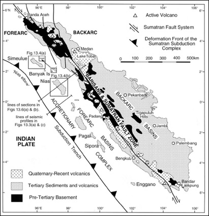
GOCE gravity satellite data can be used for regional fault detection because the observation area is wide and not limited by area. In this study, GOCE satellite data is used to detect geological structures on the island of Sumatra, the results of which are used as the basis for disaster mitigation. GOCE data and SGG-UGM-2 were processed using the GOCE User Toolbox (GUT) software to produce a gravity disturbance map and a complete bouguer anomaly map. The GOCE obtained results were validated using the SGG-UGM-2 high-resolution gravity model data. The calculation results obtained that the gravity disturbance value from the GOCE data was around -140 to 200 mGal, while the value of the gravity disturbance from the SGG-UGM-2 data was around -180-300 mGal. The GOCE gravity disturbance map and the SGG-UGM-2 can detect the Subduction Trench, Mentawai Fault, and West Andaman Fault on Sumatra Island with negative values, while the Sumatran Fault Zone (SFZ) along Sumatra Island with positive values in line with the presence of mountain ranges. The results of the SGG-UGM-2 data processing for the gravity disturbance are more detailed than GOCE because the SGG-UGM-2 data degree is higher than that of GOCE. GOCE complete bouguer anomaly value is around 40-560 mGal, while the value of complete bouguer anomaly SGG-UGM-2 is around 60-560 mGal. The complete bouguer anomaly maps from GOCE and SGG-UGM-2 can detect patterns from the Subduction Trench, Mentawai Fault, and West Andaman Fault but cannot clearly detect SFZ. The complete bouguer anomaly can also detect differences between oceanic and continental crust. The GOCE and the SGG-UGM-2 complete bouguer anomaly map show almost similar patterns and the ability to detect geological structures for sub and regional Sumatra Island. In addition, GOCE data detect geological structures more clearly than GRACE data.
Downloads
References
Asniar, Safani, J., & Asfar, S. (2020). Pendugaan Struktur Bawah Permukaan Daerah Buton Utara Provinsi Sulawesi Tenggara Berdasarkan Data Anomali Grvitasi Lokal Citra Satelit GGMplus. Jurnal Rekayasa Geofisika Indonesia, 02(01), 20–27.
Barber, A. J., Crow, M. J., & Milsom, J. s. (2005). Sumatra : Geology, Resources and Tectonic Evolution (Vol. 66). The Geological Society.
Bauer Marschallinger, B., Paulik, C., & Schaufler, S. (2015). Algorithm Theoretical Basis Document (GOCE+ GeoExplore) (Issue 2.2).
Chen, Q., Shen, Y., Francis, O., Chen, W., Zhang, X., & Hsu, and H. (2018). JGR Solid Earth - 2018 - Chen - Tongji‐Grace02s and Tongji‐Grace02k High‐Precision Static GRACE‐Only Global Earth s.pdf.
European Space Agency. (2014). ESA’s gravity mission GOCE.
Hurukawa, N., Wulandari, B. R., & Kasahara, M. (2014). Earthquake history of the Sumatran fault, Indonesia, since 1892, derived from relocation of large earthquakes. Bulletin of the Seismological Society of America, 104(4), 1750–1762.
Julzarika, A., Suhadha, A. G., & Prasasti, I. (2020). Plate and faults boundary detection using gravity disturbance and Bouguer gravity anomaly from space geodesy. Sustinere: Journal of Environment and Sustainability, 4(2), 117–131.
Li, J., Chen, J., & Zhang, Z. (2014). Seismologic applications of GRACE time-variable gravity measurements. Earthquake Science, 27(2), 229–245.
Liang, W., Li, J., Xu, X., Zhang, S., & Zhao, Y. (2020). A High-Resolution Earth’s Gravity Field Model SGG-UGM-2 from GOCE, GRACE, Satellite Altimetry, and EGM2008. Engineering, 6(8), 860–878.
Muksin, U., Irwandi, I., Idris, Y., Rusydy, I., Ningsih, W. A., Arifullah, & Vadzla, L. (2019). Sesar Aktif dan Kerentanan Seismik Aceh Tenggara. In Tsunami and Disaster Mitigation Research Center.
Natawidjaja, Danny H. (2018). Updating active fault maps and sliprates along the Sumatran Fault Zone, Indonesia. IOP Conference Series: Earth and Environmental Science, 118(1).
Natawidjaja, Danny Hilman, & Triyoso, W. (2007). the Sumatran Fault Zone — From Source To Hazard. Journal of Earthquake and Tsunami, 01(01), 21–47.
Putri, E., Pujiastuti, D., & Kurniawati, I. (2016). Analisis Karakteristik Prakiraan Berakhirnya Gempa Susulan pada Segmen Aceh dan Segmen Sianok ( Studi Kasus Gempa 2 Juli 2013 dan 11 September 2014 ). Jurnal Fisika Unand, 5(1), 73–77.
Rio, M. H., & Dinardo, S. (2011). GUT Tutorial. ESA Website, December, 1–81.
Saraswati, A. T., & Anjasmara, I. M. (2010). Analisa Anomali Gayaberat Terhadap Kondisi Tatanan Tektonik Zona Subduksi Sunda Megathrust Di Sebelah Barat Pulau Sumatera. GEOID, 10, 75–80.
Sieh, K., & Natawidjaja, D. (2000). Neotectonics of the Sumatran fault, Indonesia. Journal of Geophysical Research: Solid Earth, 105(B12), 28295–28326.
Sugiyanto, D., Zulfakriza, Ismail, N., Adriansyah, F., Meilano, I., & Abidin, H. . (2011). Analisa Deformasi Permukaan Patahan Aktif Segmen Seulimum dan Segmen Aceh. Prosiding Seminar Hasil Penelitian Kebencanaan TDMRC-Unsyiah, Banda Aceh, April, 72–77.
Telford, W. M., Geldart, L. P., & Sheriff, R. E. (1990). Applied geophysics. In Cambridge University Press.
Van der Meijde, M., Pail, R., Bingham, R., & Floberghagen, R. (2015). GOCE data, models, and applications: A review. International Journal of Applied Earth Observation and Geoinformation, 35(PA), 4–15.
Zhang, Y. Z., Xu, H. J., Wang, W. D., Duan, H. R., & Zhang, B. P. (2011). Gravity anomaly from satellite gravity gradiometry data by GOCE in Japan Ms9.0 strong earthquake region. Procedia Environmental Sciences, 10(PART A), 529–534.
Downloads
Published
Issue
Section
License
Copyright @2019. This is an open-access article distributed under the terms of the Creative Commons Attribution-ShareAlike 4.0 International License which permits unrestricted use, distribution, and reproduction in any medium. Copyrights of all materials published in JGEET are freely available without charge to users or / institution. Users are allowed to read, download, copy, distribute, search, or link to full-text articles in this journal without asking by giving appropriate credit, provide a link to the license, and indicate if changes were made. All of the remix, transform, or build upon the material must distribute the contributions under the same license as the original.


