
Disaster Mitigation for Palu City Residents in Dealing with Liquefaction Disasters in Accordance of Spatial Patterns of Palu City, Central Sulawesi Province, Indonesia.
DOI:
https://doi.org/10.25299/jgeet.2020.5.4.5653Keywords:
Disaster, Geology, Liquefaction, Spatial Pattern, MitigationAbstract
Potential natural hazards in Palu City by paying attention to the real physical characteristics of Palu City are categorized as having a high level of disaster hazard. The geological character of both the geological structure and geological engineering in the Palu region shows the great potential for geological disaster hazards. On September 28, 2018, at 18: 02 CIT, an earthquake measuring 7.4 on the Richter scale, the quake's center located in 26 km of Donggala district and 80 km northwest of Palu City. By observing the epicenter's location and the depth of the hypo-central earthquake, it appears that this shallow earthquake occurred due to activity in the Palu Koro fault zone.
This fault is the most active in Sulawesi and is the most active in Indonesia with a movement of 7 cm per year. Liquidity disasters or ground liquefaction are also the effects of an earthquake. Shocks a massive quake causes the soil to melt this thing occurs when the saturated soil loses strength and stiffness due to stress. The Petobo area and the Balaroa - Perumnas are close to the Palu Koro active fault line and the land in the area is composed of soft material from the sedimentation process. This area is shallow groundwater with high soil permeability values, namely in the Petobo area and Perumnas - Balaroa.
The purpose of this study is to analyze the potential liquefaction disaster in Palu City and analyze the Palu City resident ability against Liquefaction Hazard Prone. This research uses a descriptive qualitative analysis method. Potential liquefaction disasters were analyzing qualitatively based on geological conditions and disaster locations. Disaster mitigation capabilities were analyzed qualitatively based on the Palu City Spatial Pattern. One of the hazards caused by an earthquake that has the potential to be a disaster in Palu City is liquefaction.
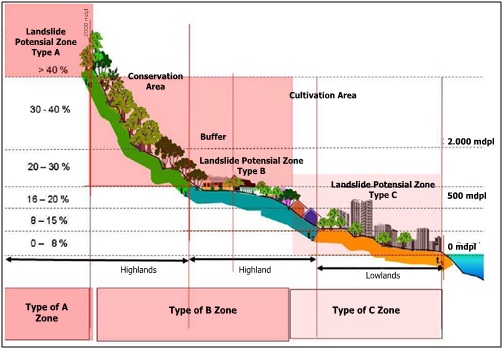
The ability of residents to mitigate liquefaction in Palu City is influenced by local wisdom which is reflected in ancient times when people lived in the highlands or hills. the concept of building structures, land use, and spatial planning patterns in Palu City which can reduce the threat of liquefaction.
Downloads
References
Badan Standarisasi nasional, 2018. SNI 8460-2017 Persyaratan Perancangan Geoteknik.
Balitbang_PUPR, 2018. Kajian Gempa Palu Provinsi Sulawesi Tengah 28 September 2018 (M7.4), Pusat Litbang Perumahan dan Pemukiman, Balitbang PUPR Pusat.
BAPPENAS, 2019a. Proyek Pengembangan Rencana Ketahanan Risiko Bencana Regional di Sulawesi Tengah. Palu.
BAPPENAS, 2019b. Proyek Pengembangan Rencana Ketahanan Risiko Bencana Regional di Sulawesi Tengah.
BAPPENAS, 2019c. Proyek Pengembangan Rencana Ketahanan Risiko Bencana Daerah di Sulawesi Tengah tentang Perencanaan Tata Ruang berdasarkan Pengurangan Risiko Bencana di Sigi. Palu.
BNPB, 2013. KEJADIAN BENCANA INDONESIA AWAL TAHUN 2013, Majalah GEMA BNPB.
BPBD, 2018. Kawasan Rawan Bencana di Kota Palu, Analisis Kebencanaan.
Harun Mallisa, Turu’allo, G., Mallisa, Z., 2009. Mikrozonasi seismic dan analisis respon site specific kota palu. SMARtek 7, 1–9.
Janat, N.R., Wilopo, W., Indrawan, I.G.B., 2017. Kajian Geologi Teknik di Kawasan Pertambangan Emas Poboya, Palu, Sulawesi Tengah, Proceeding, Seminar Nasional Kebumian Ke-10 Peran Ilmu Kebumian dalam Pembangunan Infrastruktur di Indonesia.
Kementrian_PUPR, 2016. Peraturan Menteri Pekerjaan Umum Dan Perumahan Rakyat Republik Indonesia Nomor 05/PRT/M/2016.
Marjiyono, Kusumawardhani, H., Soehaimi, A., 2013. STRUKTUR GEOLOGI BAWAH PERMUKAAN DANGKAL BERDASARKAN INTERPRETASI DATA GEOLISTRIK, Studi Kasus Sesar Palu Koro. J. Geol. dan Sumberd. Miner. 23, 39–46.
Mina, E., Kusuma, R.I., Sudirman, S., 2018. Analisa Potensi Likuifaksi Berdasarkan Data Spt (Studi Kasusproyek Pembangunan Gedung Baru Untirta Sindang Sari ). J. Fondasi 7, 11–21.
Pakpahan, S., Ngadmanto, D., Masturyono, 2015. Analisis Kegempaan di Zona Sesar Palu Koro, Sulawesi Tengah. Lingkung. dan bencana Geol. 6, 253–264.
pemerintah daerah, 2019a. MATERI TEKNIS RENCANA POLA RUANG.
pemerintah daerah, 2019b. LAMPIRAN MATERI TEKNIS REVISI RTRW KOTA PALU. Palu, pp. 80–92.
pemerintah daerah, 2010. Peraturan Daerah Kota Palu Nomor : 16 Tentang Wilayah Kota Palu.
Peraturan_Gubernur, 2019. Peraturan Gubernur Sulawesi Tengah Nomor 10 Tahun 2019 Tentang Rencana Rehabilitasi Dan Rekontruksi Pasca Bencana.
Rakhmawan, M.U., Sutaryono, S., Setiowati, S., 2019. Potensi Pengadaan Tanah Berbasis Kebencanaan di Kota Palu. J. Tunas Agrar. 2, 1–18.
Wicaksono, G., 2019. Palu Vertical Settlement, Fakultas Muhamadiyah Surakarta. Surakarta.
Widyaningrum, R., 2012. Penyelidikan geologi teknik potensi liquifaksi daerah Palu , Provinsi Sulawesi Tengah. Kementrian Energi dan Sumber Daya Miner. 43.
Downloads
Published
Issue
Section
License
Copyright @2019. This is an open-access article distributed under the terms of the Creative Commons Attribution-ShareAlike 4.0 International License which permits unrestricted use, distribution, and reproduction in any medium. Copyrights of all materials published in JGEET are freely available without charge to users or / institution. Users are allowed to read, download, copy, distribute, search, or link to full-text articles in this journal without asking by giving appropriate credit, provide a link to the license, and indicate if changes were made. All of the remix, transform, or build upon the material must distribute the contributions under the same license as the original.


