
Investigation of Groundwater Potential using Electrical Resistivity Method and Hydraulic Parameters in Lam Apeng, Aceh Besar, Indonesia.
DOI:
https://doi.org/10.25299/jgeet.2020.5.4.5501Keywords:
Groundwater, Electrical Resistivity, Hydraulic Parameter, Lam ApengAbstract
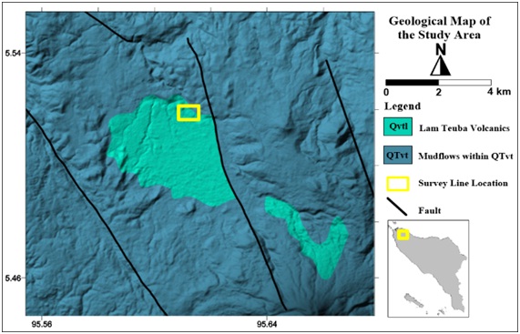
Lam Apeng is a village with a majority of people living as farmers, which causes the need of water for agriculture is increasing. The water demand in this area continues to increase as the population increases, for various purposes. The objective of this study is to determine the distribution of the groundwater layer using the electrical resistivity method and to determine groundwater potential using hydraulic parameters. This research is conducted using 2 measurement line with a length of each line is 112 meters and distances of each electrode is 2 meters. The data invert using Res2Dinv software to obtain 2D subsurface lithology subsurface. At line 1, the aquifer (sand) layer is located in the second layer with a rock resistivity value of 12 Ωm - 18.6 Ωm at a depth of 8 m - 18 m. At line 2, the aquifer (sand) layer is also located in the second layer with a resistivity value of 4.6 Ωm - 18 Ωm at a depth of 5 m – 12 m. Based on the interpretation of the two measurement lines, it can be concluded that the type of aquifer in the research site is a semi unconfined aquifer. In this study, hydraulic parameters (hydraulic conductivity, longitudinal conductance, transverse resistance, and transmissivity) was calculated based on the resistivity value and the thickness of the aquifer layer. The average resistivity of the aquifer layer used is 15.3 Ωm and 11.3 Ωm, respectively for line 1 and line 2, indicating that the aquifer was moderately corrosive. Longitudinal conductance values are 0.65 Ω-1 and 0.62 Ω-1 which indicated moderate protective capacity. The transmissivity values are 6.78 m2/dayand 4.77 m2/day, which indicates that the designation in this area is low and the groundwater potential is local or only for personal consumption.
Downloads
References
Abdulrazzaq, Z.T., Al-Ansari, N., Aziz, N.A., Agbasi, O.E., Etuk, S.E., 2020. Estimation of main aquifer parameters using geoelectric measurements to select the suitable wells locations in Bahr Al-Najaf depression, Iraq. Groundw. Sustain. Dev. 11, 100437.
Alfadli, M.K., Natasia, N., 2017. Geoelectricity Data Analysis For Identification The Aquifer Configuration In Bandorasawetan , Cilimus , Kuningan , West Java Province 02.
Baeckmann, W. von, Schwenk, W., Prinz, W., Baeckmann, W. von, 1997. Handbook of cathodic corrosion protection theory and practice of electrochemical protection processes.
Barber, A.J., Crow, M.J., Milsom, J.S., 2005. Sumatra: Geology, Resources and Tectonic Evolution.
Bayewu, O.O., Oloruntola, M.O., Mosuro, G.O., Laniyan, T.A., Ariyo, S.O., Fatoba, J.O., 2018. NRIAG Journal of Astronomy and Geophysics Assessment of groundwater prospect and aquifer protective capacity using resistivity method in Olabisi Onabanjo University campus , Ago-Iwoye , Southwestern Nigeria. NRIAG J. Astron. Geophys. 7, 347–360.
Bennet, J D, Bridge, D.McC., Cameron, N.R., Djunuddin, A., Ghazali, S.A.,, Jeffery, D.H., Kartawa, W., Keats, W., Rock, N.M.S., Thomson, S.J., Whandoyo, R., 1981. Geologic Map of the Banda Aceh Quadrangle, Sumatra.
Chandra, S., Dewandel, B., Dutta, S., Ahmed, S., 2010. Geophysical model of geological discontinuities in a granitic aquifer: Analyzing small scale variability of electrical resistivity for groundwater occurrences. J. Appl. Geophys. 71, 137–148.
Dahlin, T., 2001. The development of DC resistivity imaging techniques. Comput. Geosci. 27, 1019–1029.
Darisma, D., Marwan, 2019. One-dimensional magnetotelluric inversion using levenberg-marquardt and particle swarm optimization algorithm. {IOP} Conf. Ser. Earth Environ. Sci. 364, 12035.
Davis, R.J., DeWiest, S.N., 1966. Hydrogeology. John Wiley & Sons.
deGroot‐Hedlin, C., Constable, S., 1990. Occam’s inversion to generate smooth, two‐dimensional models from magnetotelluric data. GEOPHYSICS 55, 1613–1624.
Fetter, C.W., 2001. Applied Hydrogeology. Prentice Hall, New Jersey.
Hasan, M., Shang, Y., Jin, W., Akhter, G., 2020. Estimation of hydraulic parameters in a hard rock aquifer using integrated surface geoelectrical method and pumping test data in southeast Guangdong, China. Geosci. J.
Henriet, J.P., 1976. DIRECT APPLICATIONS OF THE DAR ZARROUK PARAMETERS IN GROUND WATER SURVEYS*. Geophys. Prospect. 24, 344–353.
Krásný, J., 1993. Classification of Transmissivity Magnitude and Variation. Groundwater 31, 230–236.
Loke, M.H., Barker, R.D., 1996. Rapid least-squares inversion of apparent resistivity pseudosections by a quasi-Newton method1. Geophys. Prospect. 44, 131–152.
Maillet, R., 1947. THE FUNDAMENTAL EQUATIONS OF ELECTRICAL PROSPECTING. GEOPHYSICS 12, 529–556.
Metwaly, M., El-Qady, G., Massoud, U., El-Kenawy, A., Matsushima, J., Al-Arifi, N., 2010. Integrated geoelectrical survey for groundwater and shallow subsurface evaluation: case study at Siliyin spring, El-Fayoum, Egypt. Int. J. Earth Sci. 99, 1427–1436.
Mohamaden, M.I.I., Ehab, D., 2017. NRIAG Journal of Astronomy and Geophysics Application of electrical resistivity for groundwater exploration in Wadi. NRIAG J. Astron. Geophys. 6, 201–209.
Mohamaden, M.I.I., Hamouda, A.Z., Mansour, S., 2016. Application of electrical resistivity method for groundwater exploration at the Moghra area , Western Desert , Egypt. Egypt. J. Aquat. Res. 42, 261–268.
Muchingami, I., Hlatywayo, D.J., Nel, J.M., Chuma, C., 2012. Electrical resistivity survey for groundwater investigations and shallow subsurface evaluation of the basaltic-greenstone formation of the urban Bulawayo aquifer. Phys. Chem. Earth 50–52, 44–51.
Perdomo, S., Kruse, E.E., Ainchil, J.E., 2018. Estimation of hydraulic parameters using electrical resistivity tomography (ERT) and empirical laws in a semi-confined aquifer. Near Surf. Geophys. 16, 627–641.
Sasaki, Y., 1992. RESOLUTION OF RESISTIVITY TOMOGRAPHY INFERRED FROM NUMERICAL SIMULATION1. Geophys. Prospect. 40, 453–463.
Soupios, P.M., Kouli, M., Vallianatos, F., Vafidis, A., Stavroulakis, G., 2007. Estimation of aquifer hydraulic parameters from surficial geophysical methods: A case study of Keritis Basin in Chania (Crete – Greece). J. Hydrol. 338, 122–131.
Suryadi, A., Bagus, D., Putra, E., Kausarian, H., Prayitno, B., 2018. Engineering , Environment , and Technology Groundwater exploration using Vertical Electrical Sounding ( VES ) Method at Toro Jaya , Langgam , Riau 03, 226–230.
Syukri, M., Saad, R., 2017. Seulimeum segment characteristic indicated by 2-D resistivity imaging method. NRIAG J. Astron. Geophys. 6, 210–217.
Telford, W.M., Geldart, L.P., Sheriff, R.E., 1990. Applied Geophysics, 2nd ed. Cambridge University Press.
Downloads
Published
Issue
Section
License
Copyright @2019. This is an open-access article distributed under the terms of the Creative Commons Attribution-ShareAlike 4.0 International License which permits unrestricted use, distribution, and reproduction in any medium. Copyrights of all materials published in JGEET are freely available without charge to users or / institution. Users are allowed to read, download, copy, distribute, search, or link to full-text articles in this journal without asking by giving appropriate credit, provide a link to the license, and indicate if changes were made. All of the remix, transform, or build upon the material must distribute the contributions under the same license as the original.


