Analysis of gravity anomaly decomposition and depth to basement, case study: Cenozoic Bogor Basin, Indonesia.
DOI:
https://doi.org/10.25299/jgeet.2021.6.1.5400Keywords:
Bouguer, Upward, Polynomial, Bogor Basin, Depth, BasementAbstract
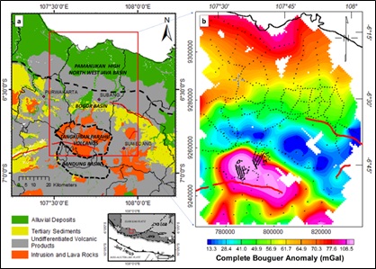
The Cenozoic Bogor Basin situated on the SE edge part of Sunda shelf is presumed to have hydrocarbon potential on its turbidite deep-water play. The deep subsurface geometry of this basin may play an important role, yet unexplored, to the hydrocarbon exploration. The gravity method is advantageous to illuminate the subsurface structure on the arbitrary depth and various sources. Eight-hundred-thirty-eight points of ground-based gravity survey were collected on roughly one kilometer spacing in the North of Bandung to Pamanukan region covering the Cenozoic Bogor Basin on the Subang-Purwakarta segment to generate complete Bouguer anomaly (CBA) map. This study examines the two robust methods of gravity anomaly decomposition (i.e., polynomial trend surface and upward continuation) by using multiple parameters to match the geological background. Radially averaged power spectrum was used to estimate the depth of anomalous source corresponds to the top of basement layer and resulting 4 km basement depth in North West Java basin and below 1 km on Tangkuban Parahu volcanic zone. The resulting estimated depth of Cenozoic Bogor Basin was evaluated by the matched a priori published data on those two areas and revealed the depth of depocenter (deepest sediment) on the Cenozoic Bogor Basin is up to 9 km, quite a deeper extent than previously assumed.
Downloads
References
Arisona, A., Nawawi, M., Khalil, A.E., Abdulrahman, A., 2018. Assessment of Microgravity Anomalies of Soil Structure for Geotechnical 2D Models. J. Geosci. Eng. Environ. Technol. 3, 151.
Arisona, A., Nawawi, M., Khalil, A.E., Abdulrahman, A., 2018. Assessment of Microgravity Anomalies of Soil Structure for Geotechnical 2D Models. J. Geosci. Eng. Environ. Technol. 3, 151.
Armandita, C., Raharjo, B., Satyana, A.H., Nugraha, Wanasherpa, Graha, S., Racmat, S., 2002. Perkiraan inversi Sesar Baribis serta perannya terhadap proses sedimentasi dan kemungkinan adanya “reworked source” pada endapan turbidit lowstand setara Talang Akar (Studi pendahuluan di daerah Sumedang dan sekitarnya). Bul. Geol. Inst. Teknol. Bandung 34.
Blakely, R.J., 1995. Potential theory in gravity and magnetic applications. Cambridge University Press.
Fansuri, T., Pramudito, D., Setyawan, D., Apriansyah, B., Ibrahim, M.S., Riyadi, A., 2019. Opportunity to Increase Production: Prove Low Resistivity Zone of CBA (Cibulakan Atas) Sandstone Reservoir in Cilamaya Structure, PT. Pertamina EP Asset 3 Field Subang, in: Joint Convention Yogyakarta 2019.
Handayani, L., 2019. Active Fault Zones of The 2006 Yogyakarta Earthquake Inferred from Tilt Derivative Analysis of Gravity Anomalies. Ris. Geol. dan Pertamb.
Hinze, W.J., Von Frese, R.R.B., Saad, A.H., 2013. Gravity and magnetic exploration: Principles, practices, and applications. Cambridge University Press.
Irsyam, M., Widiyantoro, S., Natawidjaya, D.H., Meilano, I., Rudyanto, A., Hidayati, S., Triyoso, W., Hanifa, N.R., Djarwadi, D., Faizal, L., 2017. Peta sumber dan bahaya gempa Indonesia tahun 2017, Pusat Penelitian dan Pengembangan Perumahan dan Permukiman, Kementerian Pekerjaan Umum dan Perumahan Rakyat (in Indonesian).
Jacobsen, B.H., 1987. Case for upward continuation as a standard separation filter for potential-field maps. Geophysics 52, 1138–1148.
Kamtono, K., Wardhana, D.D., 2012. Nose Structure Delineation of Bouguer Anomaly as the Interpretation Basis of Probable Hydrocarbon Traps: A Case Study on the Mainland Area of Northwest Java Basin. Indones. J. Geosci. 7.
Kanthiya, S., Mangkhemthong, N., Morley, C.K., 2019. Structural interpretation of Mae Suai Basin, Chiang Rai Province, based on gravity data analysis and modelling. Heliyon 5, e01232.
Kebede, H., Alemu, A., Fisseha, S., 2020. Upward continuation and polynomial trend analysis as a gravity data decomposition, case study at Ziway-Shala basin, central Main Ethiopian rift. Heliyon 6, e03292.
Martodjojo, S., 2003. Evolusi Cekungan Bogor Jawa Barat, Penerbit ITB Bandung.
Martyshko, P.S., Ladovskii, I. V., Byzov, D.D., Tsidaev, A.G., 2018. Gravity data inversion with method of local corrections for finite elements models. Geosci. 8.
Patmosukismo, S., Yahya, I., 1974. The Basement Configuration of the North West Java Area, in: Proceedings Indonesian Petroleum Association. pp. 129–152.
Pranata, B., Yudistira, T., Widiyantoro, S., Brahmantyo, B., Cummins, P.R., Saygin, E., Zulfakriza, Z., Rosalia, S., Cipta, A., 2019. Shear wave velocity structure beneath Bandung basin, West Java, Indonesia from ambient noise tomography. Geophys. J. Int.
Sari, A.M., Soebowo, E., Fakhrurrozi, A., Syahbana, A.J., Tohari, A., 2019. Microzonation of Soil Amplification Based on Microtremor, Spt and Cptu Data in Bandung Basin. Ris. Geol. dan Pertamb. 29, 53.
Satyana, A.H., Armandita, C., 2004. Deepwater Plays of Java, Indonesia: Regional evaluation on opportunities and risks, in: Deepwater and Frontier Exploration in Asia & Australasia Symposium, Indonesian Petroleum Association. pp. 293–319.
Satyana, A.H., Armandita, C., Raharjo, B., Syafri, I., 2002. New Observations on the Evolution of the Bogor Basin, West Java: Opportunities for Turbidite Hydrocarbon Play. Bul. Geol. Inst. Teknol. Bandung 1–16.
Setiadi, I., 2018. Basement Configuration and Delineation of Banyumas Subbasin Based On Gravity Data Analysis. J. Geol. dan Sumberd. Miner. 18, 67–76.
Setiadi, I., Pratama, A.W., 2018. Pola Struktur dan Konfigurasi Geologi Bawah Permukaan Cekungan Jawa Barat Utara Berdasarkan Analisis Gayaberat Structural Pattern and Subsurface Geological Configuration of North West Java Basin Based on Gravity Analysis. J. Geol. dan Sumberd. Miner. 19, 59–72.
Smyth, H.R., Hall, R., Nichols, G.J., 2008. Cenozoic volcanic arc history of East Java, Indonesia: The stratigraphic record of eruptions on an active continental margin. Spec. Pap. Geol. Soc. Am. 436, 199–222.
Soulisa, B., Sujanto, F.X., 2006. Hydrocarbon Occurrences in the Kandanghaur-Cemara Area, North West Java.
Spector, A., Grant, F.S., 1970. Statistical Models for Interpreting Aeromagnetic Data. Geophysics.
Sribudiyani, S., Nanang, M., Ryacudu, R., Kunto, T., Astono, P., Prasetya, I., Sapiie, B., Asikin, S., Harsolumakso, A.H., Yulianto, I., 2003. The Collision of the East Java Microplate and Its Implication for Hydrocarbon Occurrences in the East Java Basin. Proceeding Indones. Pet. Assoc. 29th.
Tonkin, P.C., Himawan, R., 1999. Basement lithology and its control on sedimentation, trap formation and hydrocarbon migration, widuri-intan oilfields, se sumatra. J. Pet. Geol. 22, 141–165.
Waltham, D., Hall, R., Smyth, H.R., Ebinger, C.J., 2008. Basin formation by volcanic arc loading. Spec. Pap. Geol. Soc. Am. 436, 11–26.
Wardhana, D.D., Kamtono, K., Gaol, K.L., 2016. Struktur Tinggian Di Sub Cekungan Majalengka Berdasarkan Metode Gayaberat. J. Ris. Geol. dan Pertamb. 26, 85.
Downloads
Published
Issue
Section
License
Copyright @2019. This is an open-access article distributed under the terms of the Creative Commons Attribution-ShareAlike 4.0 International License which permits unrestricted use, distribution, and reproduction in any medium. Copyrights of all materials published in JGEET are freely available without charge to users or / institution. Users are allowed to read, download, copy, distribute, search, or link to full-text articles in this journal without asking by giving appropriate credit, provide a link to the license, and indicate if changes were made. All of the remix, transform, or build upon the material must distribute the contributions under the same license as the original.