
The Weak Soil Investigation at the Slope Zone in the Hot Spring Area, Rokan Hulu, Indonesia
DOI:
https://doi.org/10.25299/jgeet.2019.4.4.4258Keywords:
Geoelectrical Resistivity, Rokan Hulu, Slope Failure, SoilAbstract
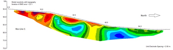
The slope failure can occur due to the soil on the slope area is relatively porous and the surface water is easily to move in the soil. The zone of the weak zone of the soil should be detected early to avoid the ground mass movement on the slope area. This study is to investigate the weak zone of the soil on the slope area of the hot spring tourism location using geoelectrical resistivity and soil property analysis methods. The Wenner configuration with a total of 40 electrodes has been employed at each four resistivity survey lines. The electrode spacing was adjusted to be 2 – 5 meter in order to get relatively higher resolution of the resistivity data. Soil samples were collected at several site to measure the soil characteristics of the study area. The soil analysis results show that the study area consist of gravel, sand, clay, silt and weathered methasediment. The geoelectrical resistivity model shows the relatively low resistivity value of about 30 ohm.m at the slope zone which is indicating that the soil has higher porosity. Generally only a few locations with the weak soil zone detected in the slope of the hot spring area, however, it is not potential for the ground mass movement due to the soil is relatively thin.
Downloads
References
Geotomo, 2007, Rapid 2-D Resistivity & IP inversion using the least-squares method. GEOTOMO SOFTWARE RES2DINV ver. 3.56. Malaysia. www.geoelectrical.com
Islami, N., Irianti M., Nor M., 2018a. Geophysical survey for groundwater potential investigation in peat land area, Riau, Indonesia. IOP Conference Series: Earth and Environmental Science. 144 (1), 012001. doi: 10.1088/1755-1315/144/1/012001
Islami, N., Taib, S.H., Yusoff, I., Ghani, A.A., 2018b. Integrated geoelectrical resistivity and hydrogeochemical methods for delineating and mapping heavy metal zone in aquifer system. Environmental earth sciences, 77 (10), 383. Doi: 10.1007/s12665-018-7574-4
Jie, D., Mingsheng, L., Qiang, X., Lu, Z., Minggao, T., Jianya, G., 2018. Detection and displacement characterization of landslides using multi-temporal satellite SAR interferometry: A case study of Danba County in the Dadu River Basin. Engineering Geology, 240, 95-109. doi: 10.1016/j.enggeo.2018.04.015
Loredana, A., Roberto, C., Francesco, D.P., Francesco, M., 2017. Geo-hydrological risk perception: A case study in Calabria (Southern Italy), International Journal of Disaster Risk Reduction, 25, 301-311. Doi: 10.1016/j.ijdrr.2017.09.022
Margherita, C.S., Andrea, W., Vincenzo, P., Lisa, B., Anne, M., Monica, G., 2018. Forensic investigations of the CimaSalti Landslide, northern Italy, using runout simulations. Geomorphology, 318, 172-186. doi: 10.1016/j.geomorph.2018.04.013.
Rock, N.M.S., Aldis, D.T., Aspden, J.A., Clarke, M.C.G., Djunuddin, Kartawa, W., Miswar, Thompson, S.J., Whandoyo, R., 1983. Geologic Map of the Lubuksikaping Quadrangle, Sumatra. Geological Research and Development Center, Indonesia.
Satoru, K., Hidehisa, N., Sei-ichi, Y., Naoya, I., Tomoyuki, O., 2015. Large deep-seated landslides controlled by geologic structures: Prehistoric and modern examples in a Jurassic subduction–accretion complex on the Kii Peninsula, central Japan. Engineering Geology, 186, 44-56. Doi: 10.1016/j.enggeo.2014.10.018
Shuai, Z., Qiang, X., Zeming, H., 2016. Effects of rainwater softening on red mudstone of deep-seated landslide, Southwest China. Engineering Geology, 204, 1-13. Doi: 10.1016/j.enggeo.2016.01.013
Telford, W.M., Geldart, L.P., Sheriff, R.E., 1990. Applied Geophysics, 2nd Edition, Cambridge University.
Xuanmei, F., Weiwei, Z., Xiujun, D., Ceesvan, W., Qiang, X., Lanxin, D., Qin, Y., Runqiu, H., Hans-Balder, H., 2018. Analyzing successive landslide dam formation by different triggering mechanisms: The case of the Tangjiawan landslide, Sichuan, China. Engineering Geology, 243, 128-144.
Zbigniew, B., 2018. Identification of flysch landslide triggers using conventional and ‘nearly real-time’ monitoring methods – An example from the Carpathian Mountains, Poland. Engineering Geology, 244, 41-56. doi: 10.1016/j.enggeo.2018.07.012.
Downloads
Published
Issue
Section
License
Copyright @2019. This is an open-access article distributed under the terms of the Creative Commons Attribution-ShareAlike 4.0 International License which permits unrestricted use, distribution, and reproduction in any medium. Copyrights of all materials published in JGEET are freely available without charge to users or / institution. Users are allowed to read, download, copy, distribute, search, or link to full-text articles in this journal without asking by giving appropriate credit, provide a link to the license, and indicate if changes were made. All of the remix, transform, or build upon the material must distribute the contributions under the same license as the original.


