
Analysis of Land Cover Changing and Vegetation Index at Kuranji Watershed in Padang, West Sumatera, Indonesia
DOI:
https://doi.org/10.25299/jgeet.2019.4.4.4101Keywords:
Land Cover, Landsat, Vegetation Index, WatershedAbstract
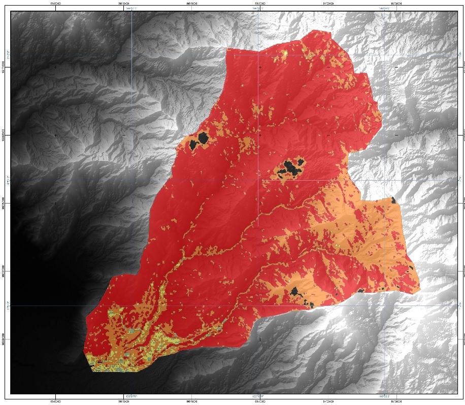
Various activities around Kuranji watershed included the land conversioncan be impacted to topographic condition and also contributed to altering the vegetation density. Remote sensing technology is an effective methodfor land cover mapping. The objectives of the present study were to analyze the changing of land cover and classifying the vegetation density index in the upstream Kuranji Watershed. This study was conducted at Kuranji Watershed in Padang, West Sumatera Province. Two Landsat images representing the changing of the watershed area during 2017 and 2018 as well as obtaining the classification of vegetation density during corresponding years.Landsat 8 OLI images were classified using a supervised classification technique, then computed the vegetation index using the Normalized Difference Vegetation Index (NDVI). The result showed that the extension of forest area, settlement area and paddy field (283.92; 35.06; and 27 Ha, respectively) and decline of mix dryland agriculture, shrub and garden area (93.68; 277.43; and 190.95 Ha respectively). Decreasing of dense vegetation found at lower dense class (6.47 Ha) and highest dense class (5535.35 Ha). Therefore, the increasing area found at the cloud, dense and higher dense class (93.17; 5525.1; and 109.94 Ha, respectively). So, it is highlighted that changing land cover and vegetation index happen during the only one-year period.
Downloads
References
Daus, S., 2005, Kaji Ulang Debit Banjir Rencana Sungai Batang Kuranji Terhadap Daerah Korong Gadang Kota Padang. Institut Teknologi Bandung, Bandung. (thesis).
Gillespie TW, Madson A, Cusack CF, Xue Y. Changes in NDVI and Human Population in Protected Areas on the Tibetan Plateau. Arctic, Antarctic, and Alpine Research, 51 (1): 428-439, DOI: 10.1080/15230430.2019.1650541.
Permatasari, R., 2017, Pengaruh Perubahan Lahan terhadap Rezim Hidrologi DAS (Studi Kasus: DAS Komering), Jurnal Teknik SipilITB Vol.24 No.1, p91-98, ISSN: 0853-2982.
Sampurno, R. M., dan A. Thoriq, 2016, Klasifikasi Tutupan Lahan Menggunakan Citra Landsat 8 Operational Land Manager (OLI) di Kabupaten SUmedang, Jurnal Teknotan Vol.10 No.2, p61-70, P-ISSN: 1978-1067, E-ISSN: 2528-6285.
Singh RP, Singh N, Singh S, Mukherjee S. 2016. Normalized Difference Vegetation Index (NDVI) Based Classification to Asses the Change in Land Use/Land Cover (LU/LC) in Lower Assam, India. International Journal of Advanced Remote Sensing and GIS. 5 (10): 1963-1970.
Tadesse, L.,Suryabhagavan KV., Sridhar G., LegesseG. 2017. Land use and Land Cover Change and Soil Erosion in Yezat Watershed, North Western, Ethiopia. International Soil and Water Conservation Research. Vol 5 (2): 85-94.
TiwariJ., Sharma SK, A., Patil, RJ. 2017. Land use andLand cover Mapping Based on Normalized Difference Vegetation Index using Remote Sensing and Geographical Information System in Banjar River Watershed of Narmada Basin. Current World Environment. Vol.2(3): 680-686.
USGS (United States Geological Survey) Landsat 8 product, 2013. (accessed 01.01.19)
Wismar, RC., Timm RK. 2004. Effect of Changing Forest and Impervious Land Covers on Discharge Characteristics of Watershed. Environmental Management. Vol 34 (1): 91-98.
Zaitunah A, Samsuri, Ahmad AG, Safitri RA. 2018. Normalized Difference Vegetation Index (NDVI) Analysis for Land Cover Types Using Landsat 0 OLI in Besitang Watershed, Indonesia. IOP Conf. Series: Earth and Environmental Science 126.
Downloads
Published
Issue
Section
License
Copyright @2019. This is an open-access article distributed under the terms of the Creative Commons Attribution-ShareAlike 4.0 International License which permits unrestricted use, distribution, and reproduction in any medium. Copyrights of all materials published in JGEET are freely available without charge to users or / institution. Users are allowed to read, download, copy, distribute, search, or link to full-text articles in this journal without asking by giving appropriate credit, provide a link to the license, and indicate if changes were made. All of the remix, transform, or build upon the material must distribute the contributions under the same license as the original.


