
Geomorphological Assessment to Tract the Flow Evolution of Kali Putih, Srumbung District, Magelang Regency, Central Java, Indonesia
DOI:
https://doi.org/10.25299/jgeet.2020.5.1.4096Keywords:
Kali Putih, flow evolution, geomorphology, laharAbstract
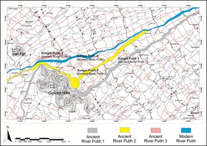
Kali Putih (The White River) is located in Srumbung district, Magelang regency, Central Java, Indonesia. It is originated from the upper slope of Merapi volcano, flowing to the Southwest direction. Kali Putih belongs to one of the most channels where frequently flowed by lahar of Merapi volcano. Based on geomorphological and geological traces found at the surrounding of modern Kali Putih channel, this indicated that the flow of Kali Putih has undergone displacement several times. The position of ancient river valley in the past has changed into the modern river valley in the present time. The existence of ancient Kali Putih is exhibited by the presence of large dry valley morphology associated with volcanic blocks, gravels, and sand sized materials with various sorting, representing the characteristics of lahar and alluvial deposits. In the present time, the former river channels are currently used by local people for agricultural and fisheries land.
Downloads
References
Anonim, 2006-2013, Google Earth.
Camus, G., Gourgaud, A., Mossand-Berthommier, p.C., Vincent, P.M., 2000, Merapi (Central Java, Indonesia): An outline of the structural and magmatological evolution, with a special emphasis to the major pyroclastic events, Journal of Volcanological and Geothermal Research, Vol 100, Elsevier: 139-163.
Kusumadinata, 1979, Data Dasar Gunungapi Indonesia (Basic data of Volcanoes of Indonesia), Departemen Pertambangan dan Energi R. I.
Kusumayudha, S.B. 2017, Gunungapi Aktif Indonesia (Active Volcanoes of Indonesia), Adicita Parama Yogyakarta.
Kusumayudha, S.B, Murwanto, H, Sutarto, Choiriyah, U, 2018, Volcanic Disaster and the Decline of Mataram Kingdom in the Central Java, Indonesia, 2nd Geomeast International Congress & Exhibition Proc., p 83 – 93, http://doi.org/10.1007/978-3-030-02032-3
Lavigne, F., J.C. Thouret, B. Voight, H. Suwa, A. Sumaryono. 2000. Lahars at Merapi Volcano, Central Java: an Overview. Journal of Volcanology and Geothermal Research, 423-456.
Murwanto H., Siregar D.A., Purwoarminta, A. 2013. Jejak Erupsi Gunung Merapi di Kabupaten Magelang Provinsi Jawa Tengah (The Tracts of Merapi Volcano Eruptions in Magelang Regency, Central Java). Jurnal Lingkungan dan Bencana Geologi. 135-147.
Paripurno, E.T. 2006, Karakter Lahar Gunung Merapi Sebagai Respon Perbedaan Jenis Erupsi Sejak Holosen (The Characteristics of Merapi Volcano Lahar as the Response of Eruption Type Difference Since Holocene), Universitas Padjadjaran, Bandung
Setyawati, S. & Ashari, A.. 2017. Geomorfologi Lereng Baratdaya Gunung Api Merapi Kaitannya Dengan Upaya Pengelolaan Lingkungan Dan Kebencanaan (Geomorphology of the Southwest Slope of Merapi Volcano Related to Environmental and Disaster Management). Geomedia, Vol 15, No. 1, DOI: https://doi.org/10.21831/gm.v15i1.16235
Thouret, J.C., Lavigne, F., Kelfoun, K., Bronto, S. 2000, Toward a revised hazard assessment at Merapi volcano, Central Java, Journal of Volcanology and Geothermal Research, Vol 100, Elsevier: 479-502.
Wirakusumah, A. D., Juwarna H., Loebis H.. 1989. Peta Geologi Gunungapi Merapi, Provinsi Daerah Istimewa Yogyakarta & Jawa Tengah (Geological Map of Merapi Volcano, Yogyakarta Special Territory and Central Java Provinces). Bandung: Badan Geologi.
Downloads
Published
Issue
Section
License
Copyright @2019. This is an open-access article distributed under the terms of the Creative Commons Attribution-ShareAlike 4.0 International License which permits unrestricted use, distribution, and reproduction in any medium. Copyrights of all materials published in JGEET are freely available without charge to users or / institution. Users are allowed to read, download, copy, distribute, search, or link to full-text articles in this journal without asking by giving appropriate credit, provide a link to the license, and indicate if changes were made. All of the remix, transform, or build upon the material must distribute the contributions under the same license as the original.


