
Groundwater Conservation Strategy Based on Water Balance at Muarabungo Groundwater Basin, Indonesia
DOI:
https://doi.org/10.25299/jgeet.2021.6.3.3976Keywords:
Groundwater Basin, water balamce, aquifer, conservation, MuarabungoAbstract
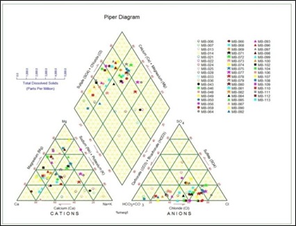
Muarabungo Groundwater Basin,is locateed in Jambi and West Sumatra Province. Based on the four rainfall stations in Muaratebo, Dusun Rantau Pandan, Sungai Bengkal and Komplek Pengairan PU Station recorded in 2008 to 2011, the precipitation (ppt) in study area is 1799.09 mm/year. Value of evapotranspiration (Evpt) in the study area is equal to 1261.26 mm / year (70.1%). Groundwater Basin of Muarabungo has an infiltration debit of 2,516,791,750 m3 / year and run-off debit (Ro) of 798 042 638 m3 / year. Rock composer in the Muarabungo Groundwater Basin are dominated by Alluvium Deposition, Quaternary rocks, and also the surrounding areas are composed by igneous and metamorphic rocks. Aquifer with a good productvity can be found on Alluvium and sedimentary rocks such as tuff sandy, whereas region without exploitable groundwater are composed by igneous rocks and metamorphic rocks. Based on groundwater quality, Groundwater Basin is divided into 13 facies, namely Ca; Cl, Mg; Cl, Na + K, Cl, Ca; HCO3, Mg; HCO3, Na + K; HCO3, Ca; No. dominant type, Mg; Nodominan type, Na + K; No. dominant type, No. dominant type; Cl, No. dominant type; HCO3, Nodominan type; SO4, and No. dominant type; No. dominant type. The result of water balance measurement in research area is used to show the areas for crisis and secure area. The water balance calculation and determining recharge and discharge areas are needed for developing conservation strategy.
Downloads
References
Danaryanto, S., & Darmawan, H. (2004). Air tanah di Indonesia dan pengelolaannya. [Jakarta]: Departemen Energi dan Sumber Daya Mineral Indonesia.
Ffolliott, P. F., Baker, M. B., Tecle, A., & Neary, D. G. (2003). A Watershed Management Approach to Land
Stewardship. Journal of the Arizona-Nevada Academy of Science.
Hadian, M., Mardiana, U., Abdurahman, O., & Iman, M. . (2006). Sebaran akuifer dan pola aliran air tanah di Kecamatan Batuceper dan Kecamatan Benda Kota Tangerang, Propinsi Banten. Indonesian Journal on Geoscience, 1(3), 115–128.
Hadian, M. S. D., Prayogi, T. E., & Azy, F. N. (2012). Groundwater Quality Assessment for Suitable Drinking and Agricultural Irrigation Using Physico-Chemical Water Analysis in the Rancaekek- Jatinangor District, West Java, Indonesia. International Proceedings of Chemical, Biological and Environmental Engineering.
Hadian, M. S. D., & Rahmat, B. (2015). Manajemen air tanah pada endapan aluvium geologi dan hidrogeologi Daerah Rawa Lakbok, Jawa Barat. Bulletin of Scientific Contribution, 13, 192–201.
Kementrian Kehutanan. 2013. Peta Penggunaan Lahan Indonesia Tahun 2012, Lembar 0814, Painan, Provinsi Sumatera Barat. Kementrian Kehutanan
Kementrian Kehutanan. 2013. Peta Penggunaan Lahan Indonesia Tahun 2012, Lembar 0815, Solok, Provinsi Riau. Kementrian Kehutanan
Kementrian Kehutanan. 2013. Peta Penggunaan Lahan Indonesia Tahun 2012, Lembar 0914, M. Bungo, Provinsi Jambi. Kementrian Kehutanan
Kodoatie, Robert J. & Syarief, R. (2010). Tata Ruang Air Tanah. Yogyakarta: Andi Press.
Purwanto, dkk., 1983. Peta Hidrogeologi Indonesia Lembar 0815 Solok. Badan Geologi. Bandung
Rosidi, dkk., 1996. Peta Geologi Lembar Panian dan Bagian Timur Lembar Muarasibeurit, Sumatera
Setiawan, dkk., 2013. Peta Hidrogeologi Indonesia Lembar 0914 Muarabungo. Badan Geologi. Bandung
Simandjuntak, dkk. 1994. Peta Geologi Lembar Muarabungo, Sumatera. Badan Geologi. Bandung
Soetrisno, dkk., 1987. Peta Hidrogeologi Indonesia Lembar 0714 Muarasibeurit sebagian Lembar 0814 Painan. Badan Geologi. Bandung
Sosrodarsono dan Takeda. 2003. Hidrologi untuk Pengairan. Jakarta : Paradnya Paramita
Todd, D. K. (1980). Groundwater Hydrology. (J. Willey, Ed.) (2nd Editio). Wiley, New York.
Downloads
Published
Issue
Section
License
Copyright @2019. This is an open-access article distributed under the terms of the Creative Commons Attribution-ShareAlike 4.0 International License which permits unrestricted use, distribution, and reproduction in any medium. Copyrights of all materials published in JGEET are freely available without charge to users or / institution. Users are allowed to read, download, copy, distribute, search, or link to full-text articles in this journal without asking by giving appropriate credit, provide a link to the license, and indicate if changes were made. All of the remix, transform, or build upon the material must distribute the contributions under the same license as the original.


