Development of Government Schools in Orangi Town, Karachi
A GIS based Case Study
DOI:
https://doi.org/10.24273/jgeet.2017.2.4.348Keywords:
Education, GIS, Proximity Analysis, Schools, Temporal AnalysisAbstract
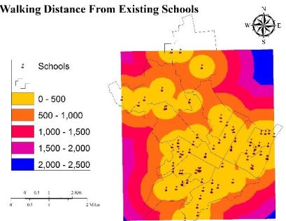
The primary school system in Pakistan needs improvement in order to provide the basic right of education to all. Government schools are not enough to cater the needs of increasing population of the country. The main goal of this study was to present a methodology for the development of government schools based on geographical information system (GIS) through a case study of Orangi Town in Karachi. In this study, first the adequacy of government schools in the study area was evaluated and then the need for additional schools with their suitable locations were identified. Data regarding school locations and students enrollments were collected from Sindh Basic Education Program of a non-profit NGO iMMAP. School building footprints were digitized from 2001 and 2013 Google Earth archived images. Population in 2013 was estimated by projecting 1998 census data downloaded from the website of the Census Bureau of Pakistan. An educated assumption of 20 % of the total population of Orangi Town was used to calculate number of primary school-aged children. Study results showed that schools existed in 2013 were not sufficient to serve all these children. This study also revealed that new schools were built during this time period, but the population growth rate was much higher than the growth rate of schools that created a big supply-demand gap. The most progressive Union Council (UC) of Orangi Town was Haryana Colony where 17 new schools were constructed between 2001 and 2013 though the required number of schools still fall short. New sites for schools were also proposed to optimally serve Orangi Town’s residents using GIS proximity analysis.
Downloads
References
Al-hanbali, N., Al-kharouf, R., Bilal, M., 2003. INTEGRATION OF GEO IMAGERY AND VECTOR DATA INTO SCHOOL MAPPING GIS DATA-MODEL FOR EDUCATIONAL DECISION SUPPORT SYSTEM IN JORDAN.
Alderman, H., Orazem, P.F., Paterno, E.M., 2001. School quality, school cost, and the public/private school choices of low-income households in Pakistan. J. Hum. Resour. 304–326.
Audet, R.H., Paris, J., 1997. GIS implementation model for schools: Assessing the critical concerns. J. Geog. 96, 293–300.
Broda, H.W., Baxter, R.E., 2003. Using GIS and GPS Technology as an Instructional Tool. Soc. Stud. 94, 158–160. doi:10.1080/00377990309600199 Distribution of population, 2012.
Falb, M.D., Kanny, D., Powell, K.E., Giarrusso, A.J., 2007. Estimating the Proportion of Children Who Can Walk to School 33, 269–275. doi:10.1016/j.amepre.2007.05.005
Hasan Arif, 2006. Orangi Pilot Project : the expansion of work beyond Orangi and the mapping of informal settlements E N V I R O N M E N T & U R B A N I Z AT I O N 18, 451–480. doi:10.1177/0956247806069626
Hasan Arif, 2000. Scaling Up of the Orangi Pilot Project Programmes : Successes , Failures and Potential.
Huang, G., Jiang, Y., 2017. Urbanization and Socioeconomic Development in Inner Mongolia in 2000 and 2010: A GIS Analysis. Sustainability 9, 235.
Lisa Aultman-Hall, Roorda Matthew, W. Baetz Brian, 1997. Using GIS for Evaluation of Neighborhood Pedestrian Accessibility _ Journal of Urban Planning and Development _ Vol 123, No 1. J. Urban Plan. Dev. 123.
Mahmood, N., 2011. The Demographic Dividend : Effects of Population Change on School Education in Pakistan.
Ministry of Finance, n.d. HIGHLIGHTS OF PAKISTAN ECONOMIC SURVEY 2013-14.
Qureshi, M.G., 2012. The gender differences in school enrolment and returns to education in Pakistan. Pak. Dev. Rev. 219–256.
Ray, R., 2000. Child labor, child schooling, and their interaction with adult labor: Empirical evidence for Peru and Pakistan. World Bank Econ. Rev. 14, 347–367.
Rehman, A., Jingdong, L., Hussain, I., 2016. Paci fi c Science Review B : Humanities and Social Sciences The province-wise literacy rate in Pakistan and its impact on the economy. Pacific Sci. Rev. A Nat. Sci. Eng. 1, 140–144. doi:10.1016/j.psrb.2016.09.001
Taki, H.M., Lubis, M.Z., 2017. GIS Modeling accessibility of community facilities: A Study Case of Depok City, Indonesia. GEOSPATIAL Inf. 1.
Downloads
Published
Issue
Section
License
Copyright @2019. This is an open-access article distributed under the terms of the Creative Commons Attribution-ShareAlike 4.0 International License which permits unrestricted use, distribution, and reproduction in any medium. Copyrights of all materials published in JGEET are freely available without charge to users or / institution. Users are allowed to read, download, copy, distribute, search, or link to full-text articles in this journal without asking by giving appropriate credit, provide a link to the license, and indicate if changes were made. All of the remix, transform, or build upon the material must distribute the contributions under the same license as the original.