
A Geophysical Survey with Magnetic Method for Interpretation of Iron Ore Deposits in the Eastern Nusawungu Coastal, Cilacap Regency, Central Java, Indonesia
DOI:
https://doi.org/10.25299/jgeet.2020.5.1.2934Keywords:
geophysical survey, magnetic method, iron ore, Eastern Nusawungu, Cilacap RegencyAbstract
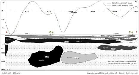
Geophysical survey with magnetic method to interpret the iron ore deposits in the Eastern Nusawungu Coastal, Cilacap Regency, Central Java, Indonesia was carried out during six month, i.e. March –August 2017, covering the area in the geographical position of 109.3462° – 109.3718° E and 7.6958° – 7.7098° S. This survey has produced total magnetic field strength data at each measuring point in the research area. The magnetic field strength data which have been obtained, then be processed, corrected, and mapped so that the local magnetic anomaly contour map can be obtained. The local magnetic anomaly contour map shows the distribution of magnetic anomalous sources in the subsurface of research area. The 2D-modeling of magnetic anomalies data has been carried out along the AB trajectory extending on the local magnetic anomaly contour map from the position of A(109.3463°E and 7.7023°S) to B (109.3688°E and 7.7053°S), so that some subsurface anomalous objects is obtained. The modelling results of magnetic anomalies data show that the research area is estimated to have the potential of iron ore deposits. The subsurface rocks deposits containing iron ore are estimated to be located below the AB trajectory with a length about of 164.85 meters, a depth ranging of 1.709 – 31.909 meters, and a magnetic susceptibility value of 0.0122 cgs unit. These rocks are interpreted as sand deposits which coexists with silt and clay containing iron ore grains from the alluvium formation. Further, iron ore is also estimated to be present in the rocks deposits below the AB trajectory which have a depth of 24.405 – 49.809 meters and 3.989 – 11.111 meters, with the magnetic susceptibility values of 0.0093 and 0.0073 cgs units.
Downloads
References
Adagunodo, T.A., Sunmonu, L.A., Adeniji, A.A., 2015. An Overview of Magnetic Method in Mineral Exploration. Journal of Global Ecology and Environment (JoGEE) 3 (1) 13 – 28.
Ahnin, W.M., Susilo, A., Sunaryo, 2013. Mapping of Manganese Ore Deposits by Using Geomagnetic Method in Aceh Jaya District, Nangro Aceh Darussalam Province, Indonesia. International Refereed Journal of Engineering and Science (IRJES) 2 (10) 12 – 20.
Amigun, J.O., Afolabi, O., Ako, B.D., 2012. Application of Airborne Magnetic Data to Mineral Exploration in The Okene Iron Ore Province of Nigeria. International Research Journal of Geology and Mining (IRJGM) 2 (6) 132 – 140.
Anonim, 2015. Potensi Energi dan Sumberdaya Mineral. Kamar Dagang dan Industri Kabupaten Cilacap.
Antaranews.com, 2017. Cadangan Pasir Besi di Cilacap Menurun. Edisi Sabtu 4 Agustus 2007
Asikin, S., Handoyo, A., Prastistho, B., 1992. Peta Geologi Lembar Banyumas, Jawa. Pusat Penelitian dan Pengembangan Geologi (PPPG) Bandung.
Ba Dai, N., Dong Xue C., Xiang, K., Trong Lap, T., Akhter, Q.J., Lei Li, S., 2014. Magnetic Method Surveying and Its Application for the Concealed Ore-Bodies Prospecting of Laba Porphyry Molybdenum Ore Field in Shangri-La, Northwestern Yunnan Province, China. Journal of Geoscience and Environment Protection 2 (1) 46 – 53.
Blakely, R.J., 1995. Potential Theory in Gravity and Magnetic Applications. Cambridge University Press. New York, USA.
Ganiyu, S.A., Badmus, B.S., Awoyemi, M.O., Akinyemi, D., Olurin, O.T., 2013. Upward Continuation and Reduction to Pole Process on Aeromagnetic Data of Ibadan Area, South-Western Nigeria. Earth Science Research 2 (1) 66–73.
Grandis, H., Sumintadireja, P., 2018. Ground Magnetic Survey for Shallow Iron Ore Prospecting. EAGE-HAGI 1st Asia Pacific Meeting on Near Surface Geoscience & Engineering. 9 - 13 April 2018. Yogyakarta Indonesia.
Herman, D.Z., 2005. Kegiatan Pemantauan dan Evaluasi Konservasi Sumberdaya Mineral Daerah Kabupaten Cilacap, Propinsi Jawa Tengah. (Kolokium Hasil Lapangan).
Hikmatyar, M.S., 2016. Geologi dan Karakteristik Pantai serta Kaitannya dengan Keterdapatan Pasir Besi di Pantai Selatan Cilacap Jawa Tengah. Skripsi. Fakultas Teknik. Universitas Jenderal Soedirman Purwokerto.
Hilman, P.M., dan Tim Penyusun Lainnya, 2014. Pasir Besi di Indonesia: Geologi, Eksplorasi, dan Pemanfaatannya. Bandung: Pusat Sumberdaya Geologi, Badan Geologi, Kementerian Energi dan Sumberdaya Mineral.
Joshua, E.O., Layade, G.O., Akinboboye, V.B., Adeyemi, S.A., 2017. Magnetic Mineral Exploration Using Ground Magnetic Survey Data of Tajimi Area, Lokoja. Global Journal of Pure and Applied Sciences 23 (1) 301 – 310.
Kurnio, H., 2007. Review Of Coastal Characteristics Of Iron Sand Deposits in Cilacap Central Java. Bulletin Of The Marine Geology 22 (1) 35 – 50.
Lino, L.M., Cavallaro, F.A., Vlach, S.R.F., Coelho, D.C., 2018. 2D Magnetometric Modeling of A Basic-Intermediate Intrusion Geometry: Geophysical and Geological Approaches Applied to The Limeira Intrusion, Paraná Magmatic Province. Brazilian Journal of Geology 48 (2) 305 – 315.
Macmillan, S., Maus, S.., 2005. International Geomagnetic Reference Field – The Tenth Generation. Earth Planets Space 57 (1) 1135 – 1140.
Mariita, N.O., 2008. The Magnetic Method. Presented at Short Course III on Exploration for Geothermal Resources. UNU-GTP and KenGen Lake Naivasha, Kenya, October 24 - November 17, 2008.
Mastellone, D., Fedi, M., Lalongo, S., Paoletti, S., 2013. Volume Upward Continuation of Potential Fields from The Minimum-Length Solution: An Optimal Tool for Continuation Through General Surface. Conference Paper. September 2013. University of Naples Federico II.
Raharjo, S.A., Sehah, 2018. Eksplorasi Potensi Pasir Besi di Pesisir Barat Kecamatan Nusawungu Kabupaten Cilacap Berdasarkan Data Resistivitas Batuan Bawah Permukaan. Jurnal Fisika dan Aplikasinya 14 (3) 51 – 58.
Siregar, S., dan Budiman, A., 2015. Penentuan Nilai Suseptibilitas Magnetik Mineral Magnetik Pasir Besi Sisa Pendulangan Emas di Kabupaten Sijunjung Sumatera Barat. Jurnal Fisika Unand 4 (4) 344 – 349.
Stella E.M.S, and David, F.A., 2015. Regional Magnetic Field Trend and Depth to Magnetic Source Determination from Aeromagnetic Data of Maijuju Area, North Central, Nigeria. Physical Science International Journal 8 (3) 1 – 13.
Sehah, Raharjo, S.A., Kurniawan, M.A., 2016. Distribution of Iron Sand in the Widarapayung Coast Area at Regency of Cilacap Based on Magnetic Anomaly Data. Indonesian Journal of Applied Physics (IJAP) 6 (2) 87– 106.
Sehah, Raharjo, S.A., 2017. Application Of Magnetic Survey To Explore The Iron Ore Deposits In The Nusawungu Coastal Regency Of Cilacap Central Java. Jurnal Penelitian Fisika dan Aplikasinya 07 (02) 79 – 88.
Sehah, Raharjo, S.A., Andriyanto, I., 2017. Exploration of Iron Sand at The Eastern Coastal of Binangun in The Cilacap Regency using Magnetic Survey. Indonesian Journal of Applied Physics (IJAP) 7 (2) 71–81.
Telford W.M., Geldart L.P., Sheriff R.E., 1990. Applied Geophysics. Melbourne: Cambridge University Press.
Vincent, A., Kassim, M., Charles, M., Willis, A., Gerald, M., 2013. Geophysical Exploration of Iron Ore Deposit in Kimachia Area in Meru County in Kenya, Using Gravity and Magnetic Techniques. International Journal of Science and Research (IJSR) 2 (11) 104 – 108.
Waswa, A.K., Nyamai, C.M., Mathu, E., Ichang’I, D.W., 2015. Application of Magnetic Survey in the Investigation of Iron Ore Deposits and Shear Zone Delineation: Case Study of Mutomo-Ikutha Area, SE Kenya. International Journal of Geosciences 6 (1) 729 – 740.
Downloads
Published
Issue
Section
License
Copyright @2019. This is an open-access article distributed under the terms of the Creative Commons Attribution-ShareAlike 4.0 International License which permits unrestricted use, distribution, and reproduction in any medium. Copyrights of all materials published in JGEET are freely available without charge to users or / institution. Users are allowed to read, download, copy, distribute, search, or link to full-text articles in this journal without asking by giving appropriate credit, provide a link to the license, and indicate if changes were made. All of the remix, transform, or build upon the material must distribute the contributions under the same license as the original.


