
An Integrated Approach in Geophysical Investigation of Road Failure in Crystalline Basement Area of Nigeria
DOI:
https://doi.org/10.25299/jgeet.2019.4.4.2590Keywords:
Geophysical, Road, Failure, Idominasi, Groundwater, ClayAbstract
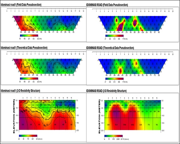
The result of the geophysical investigation carried out to access the cause of road failure and remediation measures along Ilesha-Osogbo expressway, Osun State, South-western Nigeria is presented. The study involved integrating the dipole-dipole technique of electrical resistivity method with the ground penetrating radar (GPR) method. Two dipole-dipole traverses, one long and 20 short GPR profiles were established across the failed section of the road. The dipole-dipole data were interpreted using the Diprowin software to produce the pseudo-section while the GPR data were interpreted using the RadProwin to produce the radargram. The result revealed that the failed road exhibit incompetent layer of resistivity values ranging between 17 Ωm to 171 Ωm lying between two competent layers of resistivity values greater than 200 Ωm. A combination of the dipole-dipole technique and the GPR techniques revealed the depth extend to failure to about 4.5 meters to 5 meters deep which overlie a basement rock of undifferentiated gneiss, a rock that is easily prone to weathering. The water level was observed to occur at shallow depth of about 2 meters and infiltrates the entire weathered layer. The shallow groundwater level coupled with the water-logged clayey layer derived from the weathered materials from basement rock were found responsible for the failure of this section of the road. The study recommends the excavation of the waterlogged clayey layer to a depth of about 5 to 6 meters deep into the subsurface and replacement first with heavy boulders of granitic materials and later overlaid with a thick layer of highly resistive landfill materials such as laterite. The result of the two techniques used in this work have proved to be supportive due to the integration of the double dipole technique with the GPR technique, a relatively new technique recently being introduced into road failure mapping.
Downloads
References
Adeleye,A.O.,2005.Geotechnical Investigation ofSub-grade Soil along Sections of Ibadan-Ife Highway Unpublished M.Sc. project, Obafemi Awolowo University, Ile-Ife,pp: 181
Agada, O.A. and Adegoke-Anthony, W C. 1980 Geotecnical characteristics of some residual soils and their implications on road design in Nigeria. Technical lecture. Lagos, pp:1-16.
Ajayi, L.A, 1987. Thoughts on road failures in Nigeria. Nigerian Engineer. 22(1): 10-17
Ebhohimen and Luke, 2014: ”Geophysical investigation of road failure the case of Opoji in Nigeria”.International Journal of Scientific & Engineering Research, Volume 5, Issue 1, January-2014
Elueze, A. A. (1988): Geology of the Precambrian Schist belt in Ilesa Area, Southwest Nigeria. Precambrian Geology of Nigeria. Geological Survey of Nigeria publication. Pp77-82.
Federal Road Safety Corps (FRSC, 2011) United Nation Decade of Action on Road Safety, Benin City, Nigeria. O’Flaherty C.A (1979) Highway Engineering, Edward Arnold – London.
Folami, S.L., (1992). Interpretation of aeromagnetic anomalies in Iwaraja area, Southwestern Nigeria. Journals of mining and geology, 28(2), 391-396.
Ifabiyi P.I. and Kekere, A.A 2013: Geotechnical Investigation of Road Failure along Ilorin-Ajase – Ipo Road Kwara State, Nigeria. Journal of Environment and Earth Science,Vol. 3, No.7, 2013
Nelson, R.G. and J.H. Haigh.(1990). Geophysical investigation of in lateritic terrain. Geotechnical and Environmental Geophysics. Ward, S.H. (Ed), (Geotechnical), SEG, Tulsia. 2: 133 – 154
Mohamed and Noha, 2016. Ground Magnetic, GPR, and Dipole-Dipole Resistivity for Landfill Investigation
Momoh, L.O., Akintorinwa, O., and Olorunfemi, M.O., (2008): Geophysical investigation of highway failure - a case study from the basement complex terrain of south- western Nigeria. J. Appl. Sci. Res., 4(6): 637-648.
Olorunfemi, M.O., Ojo, J.S., Sonuga, F.A., Ajayi, O., and Oladapo, M.I., “Geoelectric and electromagnetic investigation of the failed Koza and Nassarawa earth dams around Katsina, Northern Nigeria”. J. Min. Geol., Vol. 36, no. 1, pp 51-65, 2000a.
Oladapo M. I. (1998), “Geophysical and Geotechnical Investigation of Road Failure in the Basement Complex Areas of Southwestern Nigeria”, (unpublished M.Sc. thesis), Department of Applied Geophysics, Federal University of Technology, Akure.
Olorunfemi, M.O., Ojo, J.S., Sonuga, F.A., Ajayi, O., and Oladapo, M.I., “Geoelectric and electromagnetic investigation of the failed Koza and Nassarawa earth dams around Katsina, Northern Nigeria”. J. Min. Geol., Vol. 36, no. 1, pp 51-65, 2000a
Downloads
Published
Issue
Section
License
Copyright @2019. This is an open-access article distributed under the terms of the Creative Commons Attribution-ShareAlike 4.0 International License which permits unrestricted use, distribution, and reproduction in any medium. Copyrights of all materials published in JGEET are freely available without charge to users or / institution. Users are allowed to read, download, copy, distribute, search, or link to full-text articles in this journal without asking by giving appropriate credit, provide a link to the license, and indicate if changes were made. All of the remix, transform, or build upon the material must distribute the contributions under the same license as the original.


