
Correlation Between Fracture Azimuth, Surface Lineaments and Regional Tectonics: A case study from Belik District, Central Java, Indonesia
DOI:
https://doi.org/10.25299/jgeet.2019.4.1.2294Keywords:
Fracture Azimuth, Lineament, Spearman, BelikAbstract
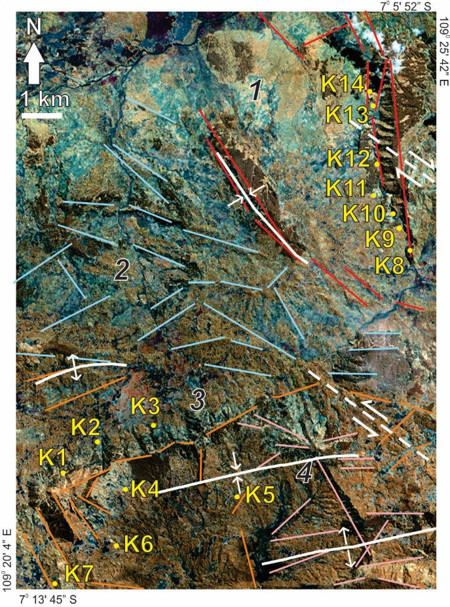
Two major strike-slip faults with northeast-southwest and northwest-southeast orientation have shifted the southern Central Java, including Belik District. Consequently, many smaller faults that have the same direction as the major faults and west-east direction folding systems were emerged. The orientation of these geologic structures could be observed from morphological features such as ridge and river. A quantitative approach was carried out to unravel the impacts of those geologic structures on the geomorphology of the study area, which is located between Slamet Mountain and Sindoro Mountain, Central Java province. The method used in this research was the structural geology analysis, including the interpretation of ridge and river lineament, the distribution of fractures, and statistical analysis. The research location is divided into four different segments based on its lineament and morphology. The lineament that has similar characteristics was tested using normality test of Kolmogorov-Smirnov. The Spearman test was used to obtain the correlation between surface lineament and fracture azimuth. All fracture azimuth, ridges and rivers tend to have northwest-southeast and northeast-southwest direction. These results show similar direction with strike-slip regional structural pattern. The statistical calculation and field observation indicate the influence of external factor on the change of the study area’s landform.
Downloads
References
Djuri, M., Samodra, H., Amin, T.C., Gafoer, S., 1998. Geological map of the Purwokerto and Tegal Quadrangles, Jawa. Geological Research and Development Centre, Indonesia.
Howard, A.D., 2003. Drainage Analysis in Geologic Interpretation: A Summation. Am. Assoc. Pet. Geol. Bull. 51, 2246–2259. https://doi.org/10.1306/5d25c26d-16c1-11d7-8645000102c1865d
Kusumayudha, S.B., Murwanto, H., 1994. Penentuan tektonogenesis komplek bancuh Karangsambung berdasarkan analisis kekar gerus, in: Seminar Geologi Dan Geotektonik Pulau Jawa Sejak Akhir Mesozoik Hingga Kuarter. Yogyakarta, 101–120.
Martodjojo, S., 1994. Data stratigrafi, pola tektonik dan perkembangan cekungan pada jalur anjakan lipatan di Pulau Jawa, Kumpulan Makalah Seminar Geologi dan Geotektonik Pulau Jawa sejak Akhir Mesozoik hingga Kuarter. Yogyakarta.
McClay, K.R., 1991. The Mapping of Geological Structures. John Wiley & Sons, England.
Pacey, A., Macpherson, C.G., McCaffrey, K.J.W., 2013. Linear volcanic segments in the central Sunda Arc, Indonesia, identified using Hough Transform analysis: Implications for arc lithosphere control upon volcano distribution. Earth Planet. Sci. Lett. 369–370, 24–33. https://doi.org/10.1016/j.epsl.2013.02.040
Ratman, N., Robinson, G., n.d. Geology from Gunung Slamet to the Dieng Plateau Central java. Geological Research and Development Centre, Indonesia.
Satyana, A.H., 2009. Disappearance of the Java ’ s Southern Mountains in Kebumen and Lumajang Depressions : Tectonic Collapses and Indentations by Java ’ s Transverse Major Fault Zones, in: UNIVERSITAS GADJAH MADA INTERNATIONAL CONFERENCE ON JAVA’S SOUTHERN MOUNTAIN. 6–7.
Satyana, A.H., 2006. ABSTRACT: New Insight on Tectonic of Central Java, Indonesia and Its Petroleum Implications; in: AMERICAN ASSOCIATION OF PETROLEUM GEOLOGISTS (AAPG) International Conference and Exhibition. p. 90061.
Satyana, A.H., 2005. Structural Indentation of Central Java: A Regional Wrench Segmentation, in: Proceedings Joint Convention 30th HAGI, 34th IAGI, 14th PERHAPI, Surabaya. Surabaya, 193–204.
Situmorang, B., 2018. Wrench Fault Tectonics and Aspects of Hydrocarbon Accumulation in Java, in: Proceedings Indonesian Petroleum Association (IPA) 5th Annual Convention. 53–66. https://doi.org/10.29118/ipa.1210.53.67
Strahler A.N., 1952. Dynamic Basis of Geomorphology. Bull. Geol. Soc. Am. 63, 923–938. https://doi.org/10.1130/0016-7606(1952)63[923:dbog]2.0.co;2
van Bemmelen, R.W., 1987. The geology of Indonesia. Springer; 2nd edition.
van Zuidam, R.A., 1986. Aerial photo-interpretation in terrain analysis and geomorphologic mapping. Smits Publishers, The Hague, Netherlands.
Vannametee, E., Babel, L.V., Hendriks, M.R., Schuur, J., de Jong, S.M., Bierkens, M.F.P., Karssenberg, D., 2014. Semi-automated mapping of landforms using multiple point geostatistics. Geomorphology 221, 298–319. https://doi.org/10.1016/j.geomorph.2014.05.032
Widagdo, A., Pramumijoyo, S., Harijoko, A., 2018. The Morphotectono-Volcanic of Menoreh-Gajah-Ijo Volcanic Rock In Western Side of Yogyakarta-Indonesia. J. Geosci. Eng. Environ. Technol. 3, 155. https://doi.org/10.24273/jgeet.2018.3.3.1715
Yudhicara, Y., Muslim, D., Sudradjat, A., 2017. Geomorphic Analysis in Determining Tectonic Activity Affected by Sumatra Fault in Liwa Region and Its Surrounding Area, Lampung, Indonesia. Indones. J. Geosci. 4, 193–208. https://doi.org/10.17014/ijog.4.3.193-208
Zadeh, R., Sarkarinejad, K., Webster, R., 2013. Spatial Heterogeneity of Tectonic Features in the Area between the Qatar-Kazerun and the Minab Faults, the Southeast of the Zagros Fold-and-Thrust Belt, Iran. Geoinformatics Geostatistics An Overv. 01, 1–14. https://doi.org/10.4172/2327-4581.1000109
Downloads
Published
Issue
Section
License
Copyright @2019. This is an open-access article distributed under the terms of the Creative Commons Attribution-ShareAlike 4.0 International License which permits unrestricted use, distribution, and reproduction in any medium. Copyrights of all materials published in JGEET are freely available without charge to users or / institution. Users are allowed to read, download, copy, distribute, search, or link to full-text articles in this journal without asking by giving appropriate credit, provide a link to the license, and indicate if changes were made. All of the remix, transform, or build upon the material must distribute the contributions under the same license as the original.


