
Analysis of Subsidence Hazards in Pandan Cave Area, Giri Mulyo Village, Marga Sekampung District, East Lampung using Analytical Hierarchy Process
DOI:
https://doi.org/10.25299/jgeet.2024.9.2.16848Keywords:
Pandan Cave, basalt lava cave, geological tourism, lava flow, Analytical Hierarchy Process (AHP), geological disaster, SubsidenceAbstract
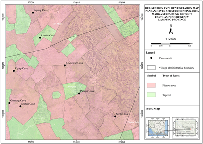
Pandan Cave is a basalt lava cave which is a unique geological tourism area located in Giri Mulyo Village, Marga Sekampung District, East Lampung Regency, Lampung Province. This cave was formed when the lava flow cooled at the top because it was in contact with the cold atmosphere, while at the bottom it was still flowing. This uniqueness caused Pandan Cave to become one of the tourist attractions that was once crowded with tourists. However, the condition of this cave is still very natural which can lead to the risk of geological disasters such as subsidence which can endanger tourists, so it is necessary to research to minimize the occurrence of geological disasters in the area. This research was conducted by observing aerial photographs, collecting data directly in the field, and then processing it with the Analytical Hierarchy Process (AHP). Parameters used in this AHP method include lithology, vegetation, weathering, rock mass class, and cave roof thickness. The existence of subsidence in the study area is influenced by weathering (34%), vegetation (31%), thickness of the cave roof layer (16%), lithology (10%), and rock mass class (9%). Based on the overlay results for each parameter that has been weighted, the Pandan Cave tourism area is divided into three subsidence hazard zone classifications, that is low hazard zone with value of 0.28-0.44, medium hazard zone with range of 0.44-0.60, and high hazard zone with range of 0.60-0.75. Through the Analytical Hierarchy Process (AHP) method and overlay of each parameter used, the distribution of subsidence hazard zones in the study area was obtained. The low threat zone of 27.57 ha is about 57.07% of the total research area, the medium threat zone is 15.86 ha or about 32.83% of the total research area, and the high threat zone is 4.88 ha or about 10. 10% of the total research area.
Downloads
References
Abdurrachman, M., Widiyantoro, S., Priadi, B., Ismail, T., 2018. Geochemistry and Structure of Krakatoa Volcano in the Sunda Strait, Indonesia. Geosciences (Basel) 8, 111.
Agustina, L., Setiawan, R., Gathot Harbowo, D., Alfarishi, B., Radityo, D., Tamara, 2023. Determine of Potential Evacuation Locations as Disaster Mitigation Against Landslides. IOP Conf Ser Earth Environ Sci 1209, 012006.
Asmare, D., 2023. Application and validation of AHP and FR methods for landslide susceptibility mapping around choke mountain, northwestern ethiopia. Sci Afr 19, e01470.
Badan Geologi, 2017. Petunjuk Teknis Asesmen Sumber Warisan Geologi. Pusat Survei Geologi.
Bieniawski, Z.T., 1989. Engineering rock mass classifications. New York, NY; John Wiley and Sons Inc., United States.
Budianta, W., 2021. Pemetaan Kawasan Rawan Tanah Longsor di Kecamatan Gedangsari, Kabupaten Gunungkidul, Yogyakarta dengan Metode Analytical Hierarchy Process (AHP). Jurnal Pengabdian kepada Masyarakat (Indonesian Journal of Community Engagement) 6, 68.
Cruden, A., Weinberg, R., 2018. Mechanisms of Magma Transport and Storage in the Lower and Middle Crust—Magma Segregation, Ascent and Emplacement, in: Volcanic and Igneous Plumbing Systems. pp. 13–53.
El Jazouli, A., Barakat, A., Khellouk, R., 2019. GIS-multicriteria evaluation using AHP for landslide susceptibility mapping in Oum Er Rbia high basin (Morocco). Geoenvironmental Disasters 6, 3.
Ermana, R., Dwiguna, R., Hesti, H., Mulyasari, R., 2022. Kajian Potensi Gua Pandan sebagai Objek Geowisata Lampung Timur. Jurnal Riset Fisika Indonesia 3, 25–31.
Indahsari, F., Muslim, D., Sukiyah, E., Iqbal, P., 2022. Analitikal Hierarki Proses Untuk Pemetaan Kerentanan Tanah Longsor Di Kecamatan Sekincau Lampung Barat (Analytical Hierarchy Process For Mapping Landslide Vulnerability In Sekincau District, Lampung Barat) 6, 624–631.
Jerram, D.A., Dobson, K.J., Morgan, D.J., Pankhurst, M.J., 2018. Chapter 8 - The Petrogenesis of Magmatic Systems: Using Igneous Textures to Understand Magmatic Processes, in: Burchardt, S. (Ed.), Volcanic and Igneous Plumbing Systems. Elsevier, pp. 191–229.
Kumar, R., Anbalagan, R., 2016. Landslide Susceptibility Mapping Using Analytical Hierarchy Process (AHP) in Tehri Reservoir Rim Region, Uttarakhand. Journal of the Geological Society of India 87.
Liu, X., Shao, Shuai, Shao, Shengjun, 2024. Landslide susceptibility zonation using the analytical hierarchy process (AHP) in the Great Xi’an Region, China. Sci Rep 14, 2941.
Mangga, S.A., Amirudin, Suwarti, T., Gafoer, S., Sidarto, 1993. Peta Geologi Lembar Tanjung Karang.
Metcalfe, I., 2017. Tectonic evolution of Sundaland. Bulletin of the Geological Society of Malaysia 63, 27–60.
Mohamad Deros, S., Din, N., Norzeli, S., Omar, R., Usman, F., Hamim, S., 2022. Land Subsidence Susceptibility Projection for Palembang Slum Area by Complex MCDM-AHP Technique. Journal of Engineering and Technological Sciences 54, 220104.
Nadi, P.A., Murad, A., 2017. Reviewing the use of Geographic Information System (GIS) to measure Sustainable Urban Transport performance. Journal of Geoscience, Engineering, Environment, and Technology 2, 171.
Natalia Sirait, H.C., Pakpahan, A., Sari, H., Al Farishi, B., Widiatama, A.J., Antosia, R., Santoso, N., 2023. Basaltic Lava Characteristic in Goa Pandan Area, Sukadana, East Lampung: Inferences from Stratigraphy and Petrography Analysis. Journal of Geoscience, Engineering, Environment, and Technology 8, 112–122.
Palmer, A.N., 2007. Cave Geology. KIP Articles 775.
Panchal, S., Shrivastava, A.Kr., 2022. Landslide hazard assessment using analytic hierarchy process (AHP): A case study of National Highway 5 in India. Ain Shams Engineering Journal 13, 101626.
Rezaei, M., Yazdani Noori, Z., Dashti Barmaki, M., 2022. Land subsidence susceptibility mapping using Analytical Hierarchy Process (AHP) and Certain Factor (CF) models at Neyshabur plain, Iran. Geocarto Int 37, 1465–1481.
Ritzema, H., 1994. Drainage Principles and Applications, Ritzema HP.
Saaty, T., 2008. Decision making with the Analytic Hierarchy Process. Int. J. Services Sciences Int. J. Services Sciences 1, 83–98.
Sahu, P., Lokhande, R.D., 2015. An Investigation of Sinkhole Subsidence and its Preventive Measures in Underground Coal Mining. Procedia Earth and Planetary Science 11, 63–75.
Satriawan, A., Ibrahim, E., Putranto, D., Affandi, A., 2018. Evaluation of Land Subsidence Impact at Lowland Areas Using Analitycal Hierarchy Process (AHP) Method. E3S Web of Conferences 68, 04017.
Taherdoost, H., 2017. Decision Making Using the Analytic Hierarchy Process (AHP); A Step by Step Approach. International Journal of Economics and Management Systems.
Taki, H.M., Maatouk, M.M.H., 2018. Spatial Statistical Analysis for Potential Transit Oriented Development (TOD) in Jakarta Metropolitan Region. Journal of Geoscience, Engineering, Environment, and Technology 3, 47.
Theinat, A.E., Modiriasari, A., Bobet, A., Melosh, J., Dyke, S., Ramírez, J., Maghareh, A., Gomez, D., 2019. Lunar lava tubes: Morphology to structural stability. Icarus 338, 113442.
Zhang, Zhihua, Zhang, S., Hu, C., Zhang, X., Yang, S., Yan, H., Zhang, Zhen, 2023. Hazard assessment model of ground subsidence coupling AHP, RS and GIS – A case study of Shanghai. Gondwana Research 117, 344–362.
Downloads
Published
Issue
Section
License
Copyright (c) 2024 Journal of Geoscience, Engineering, Environment, and Technology

This work is licensed under a Creative Commons Attribution-ShareAlike 4.0 International License.
Copyright @2019. This is an open-access article distributed under the terms of the Creative Commons Attribution-ShareAlike 4.0 International License which permits unrestricted use, distribution, and reproduction in any medium. Copyrights of all materials published in JGEET are freely available without charge to users or / institution. Users are allowed to read, download, copy, distribute, search, or link to full-text articles in this journal without asking by giving appropriate credit, provide a link to the license, and indicate if changes were made. All of the remix, transform, or build upon the material must distribute the contributions under the same license as the original.


