Morpho-Tectonic and Satellite Image Interpretation for Identifying Gardez Fault in Afghanistan
Keywords:
Tectonic, Fault, GIS, RSAbstract
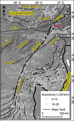
Afghanistan experiences major geological changes since it is situated in a tectonically active area where the Eurasian and Indian plates collide. The influence of the convergence reaches hundreds of kilometers beyond the boundary of the southeastern plate. High mountain ranges are shaped by the faulting, folding, and uplifting of rocks; these formations are like a complicated jigsaw puzzle, with each piece revealing a different geological narrative. During fieldwork, using a Keyhole Markup Language Zipped (KMZ) file made comprehension easier. The left-lateral strike-slip character of the active Gardez fault was revealed by combining precise image analysis and correlation with satellite imagery, which was essential for comprehensive insights during laboratory processing. Our knowledge was significantly enhanced by the topographic representation of the Sarobi fault. The Cimmerian Kandahar arc and the active Chaman and Gardez faults to the west surrounded the Katawaz basin, which was the subject of the investigation. Geological boundaries were emphasized by ophiolites situated along the north-south axial strip towards the east. Pliocene sediments predominate, and recurring tremors indicate that block movements are still occurring, which could be a sign of impending large earthquakes. This study combines morpho-tectonic analysis with the interpretation of satellite images to reveal the characteristics of the active Gardez fault and comprehend the larger geological background of Afghanistan. The results provide insightful information on dynamic geological processes and have implications for future mitigation initiatives in the area as well as the assessment of seismic danger.
Downloads
References
Adiri, Z., El Harti, A., Jellouli, A., Lhissou, R., Maacha, L., Azmi, M., . . . Bachaoui, E. M. (2017). Comparison of Landsat-8, ASTER and Sentinel 1 satellite remote sensing data in automatic lineaments extraction: A case study of Sidi Flah-Bouskour inlier, Moroccan Anti Atlas. Advances in Space Research, 60(11), 2355-2367.
Al Ghiffari, M. R., Nugroho, D., Ramadhan, R., Noor, M. R., & Wicaksono, N. (2024). The Utilization of LiCSBAS for Deformation Monitoring in Geresa Segment of Matano Fault, Central Sulawesi, Indonesia. Journal of Geoscience, Engineering, Environment, and Technology, 9(1), 28-37.
Allen, C. R., Zhuoli, L., Hong, Q., Xueze, W., Huawei, Z., & Weishi, H. (1991). Field study of a highly active fault zone: The Xianshuihe fault of southwestern China. Geological Society of America Bulletin, 103(9), 1178-1199.
Auden, J. B. (1974). Afghanistan-West Pakistan. Geological Society, London, Special Publications, 4(1), 235-253.
Benham, A., Kováč, P., Petterson, M., Rojkovic, I., Styles, M., Gunn, A., . . . Wasy, A. (2009). Chromite and PGE in the Logar ophiolite complex, Afghanistan. Applied Earth Science, 118(2), 45-58.
Bernard, M., Shen‐Tu, B., Holt, W., & Davis, D. (2000). Kinematics of active deformation in the Sulaiman Lobe and Range, Pakistan. Journal of Geophysical Research: Solid Earth, 105(B6), 13253-13279.
Griesbach, C. (1893). Notes on the Central Himalaya. Rec. Geol. Surv. India, 26(1), 19-25.
Hidayatillah, A. S., Nurcahyo, T. A., Muliawan, J. B. P., & Endarsih, A. E. (2024). Identifying Dominant Structural Pattern of Semarang City Using Digital Elevation Model and Landsat 8-OLI Imagery. Journal of Geoscience, Engineering, Environment, and Technology, 9(1), 28-37.
Molnar, P., & Tapponnier, P. (1977). The collision between India and Eurasia. Scientific American, 236(4), 30-41.
Patra, S., Shekher, M., Solanki, S., Ramachandran, R., & Krishnan, R. (2006). A technique for generating natural colour images from false colour composite images. International journal of remote sensing, 27(14), 2977-2989.
Prevot, R., Hatzfeld, D., Roecker, S., & Molnar, P. (1980). Shallow earthquakes and active tectonics in eastern Afghanistan. Journal of Geophysical Research: Solid Earth, 85(B3), 1347-1357.
Ruleman, C. A., Crone, A., Machette, M., Haller, K., & Rukstales, K. (2007). Map and database of probable and possible Quaternary faults in Afghanistan. US Geological Survey open-file report, 1103(1).
Schwartz, D. P., & Coppersmith, K. J. (1984). Fault behavior and characteristic earthquakes: Examples from the Wasatch and San Andreas fault zones. Journal of Geophysical Research: Solid Earth, 89(B7), 5681-5698.
Shnizai, Z. (2020). Mapping of active and presumed active faults in Afghanistan by interpretation of 1-arcsecond SRTM anaglyph images. Journal of Seismology, 24(6), 1131-1157.
Shnizai, Z., Talebian, M., Valkanotis, S., & Walker, R. (2022). Multiple factors make Afghan communities vulnerable to earthquakes. Temblor.
Shnizai, Z., Walker, R., & Tsutsumi, H. (2024). The Chaman and Paghman active faults, west of Kabul, Afghanistan: Active tectonics, geomorphology, and evidence for rupture in the destructive 1505 earthquake. Journal of Asian Earth Sciences, 259, 105925.
Siehl, A. (2017). Structural setting and evolution of the Afghan orogenic segment–a review. Geological Society, London, Special Publications, 427(1), 57-88.
Slater, L., & Niemi, T. M. (2003). Ground-penetrating radar investigation of active faults along the Dead Sea Transform and implications for seismic hazards within the city of Aqaba, Jordan. Tectonophysics, 368(1-4), 33-50.
Tapponnier, P., Mattauer, M., Proust, F., & Cassaigneau, C. (1981). Mesozoic ophiolites, sutures, and arge-scale tectonic movements in Afghanistan. Earth and Planetary Science Letters, 52(2), 355-371.
Ulin, R. F., Taufik, M., & Anjasmara, I. M. (2019). Application of PS-InSAR method for the land subsidence analysis using StaMPS (case study: Gresik Regency). IPTEK Journal of Proceedings Series(2), 57-59.
Wheeler, R. L., Bufe, C. G., Johnson, M. L., Dart, R. L., & Norton, G. (2005). Seismotectonic map of Afghanistan, with annotated bibliography: US Department of the Interior, US Geological Survey Reston, VA, USA.
Yusoff, I., Abir, I., Syahreza, S., Rusdi, M., Razi, P., & Lateh, H. (2020). The applications of InSAR technique for natural hazard detection in smart society. Paper presented at the Journal of Physics: Conference Series.
Zhou, X., Chang, N.-B., & Li, S. (2009). Applications of SAR interferometry in earth and environmental science research. Sensors, 9(3), 1876-1912.
Downloads
Published
Issue
Section
License
Copyright (c) 2024 Journal of Geoscience, Engineering, Environment, and Technology

This work is licensed under a Creative Commons Attribution-ShareAlike 4.0 International License.
Copyright @2019. This is an open-access article distributed under the terms of the Creative Commons Attribution-ShareAlike 4.0 International License which permits unrestricted use, distribution, and reproduction in any medium. Copyrights of all materials published in JGEET are freely available without charge to users or / institution. Users are allowed to read, download, copy, distribute, search, or link to full-text articles in this journal without asking by giving appropriate credit, provide a link to the license, and indicate if changes were made. All of the remix, transform, or build upon the material must distribute the contributions under the same license as the original.