Characteristics of Groundwater on the Eastern Slope of Mount Ciremai, Kuningan Regency, West Java, Indonesia
DOI:
https://doi.org/10.24273/jgeet.2018.3.4.1606Keywords:
Characteristic of groundwater, volcano, geology, hydrogeology, physical properties, type of faciesAbstract
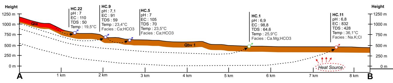
Water is a very important component for the survival of living things. Groundwater is water that has better quality compared to other water types, so groundwater is widely used to meet the needs of clean water. The research area is located on the eastern slope of Mount Ciremai which is a volcanic area that has great groundwater potential, it is seen from the many springs with large groundwater discharge. The study aims to determine the physical and chemical characteristics of groundwater on the eastern slopes of Mount Ciremai which also the district of Kuningan. The research method is done by collecting geological data and hydrogeological data. To find characteristics of groundwater chemistry, groundwater sampling was taken at 10 locations, and then tested the laboratory to determine the chemical content of groundwater. Based on the results of the research, the physical characteristics of water were shown with EC values ranging from 76,8 to 228 µS/Cm, TDS from 50 to 151 mg/L, pH value from 6.4 to 7.65, water temperature 19.3 to 25.9 oC. While one of the observation location is HC. 11 is a hot springs that has a water temperature of 36.1 oC , EC 832 µS/Cm, TDS 428 mg/L and pH 6.8. Chemical analysis results from pipe diagram show the developing facies are Ca:HCO3, Ca.Mg:HCO3, Na.K:Cl.
Downloads
References
Djuri. 1973. Peta Geologi Regional Lembar Ardjawinangun, Jawa. Direktorat Geologi Bandung.
Domenico, P.A. and Schwartz, W.F., 1990. Physical and chemical hydrogeology. John Wiley and Sons, Inc., Canada, 824p.
Irawan, D.E., Puradimaja, D.J., Notosiswoyo, S., Sumintadireja, P., 2006. Hydrogeology of Stratovolcano of Ciremai, West Java, Indonesia. IAEG congress.
Kumaresan M., Riyazuddin P., 2006. Major ion chemical of enviromental samples around suburban of Chennal city. Current SCI., 91(12), 1668 – 1677.
Piper, A. M. 1944. A Graphic Procedure in The Geochemical Interpretation of Water Analysis. Trans, Am. Geophys. Union, Washington, D.C.
Soetrisno, S. 1983. Peta Hidrogeologi Lembar V Bandung skala 1:250.000. Direktorat Geologi Tata Lingkungan. Bandung.
Downloads
Published
Issue
Section
License
Copyright @2019. This is an open-access article distributed under the terms of the Creative Commons Attribution-ShareAlike 4.0 International License which permits unrestricted use, distribution, and reproduction in any medium. Copyrights of all materials published in JGEET are freely available without charge to users or / institution. Users are allowed to read, download, copy, distribute, search, or link to full-text articles in this journal without asking by giving appropriate credit, provide a link to the license, and indicate if changes were made. All of the remix, transform, or build upon the material must distribute the contributions under the same license as the original.