
Tsunami Modeling Using DEMNAS and DEM Data from UAV Surveys for Planning Evacuation Routes on Samas Coast, Bantul Regency
DOI:
https://doi.org/10.25299/jgeet.2024.9.2.14777Keywords:
UAV Photogrammetry, COMCOT, Inundation, EvacuationAbstract
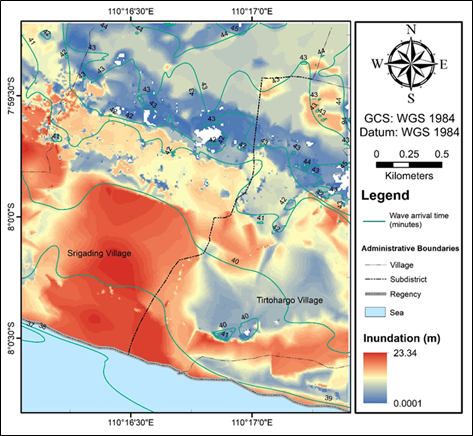
The interaction between the Indo-Australian plate and the Eurasian plate exerts significant influence on seismic activities within the southern seas of Java Island, with potential repercussions extending to the triggering of tsunamis. Given the densely populated nature of this area, especially along the southern region of Yogyakarta Province, the coast of Samas Beach and its surroundings, mitigation efforts are needed to reduce the potential loss of life caused by tsunamis. One of the mitigation efforts is making a tsunami model which can be done using the help of DEMNAS and DEM topographical data from unmanned aerial vehicle (UAV) photogrammetry. The COMCOT software is a tool used in modeling tsunamis based on a numerical model of the shallow water equation that processes tsunami generator parameters and DEM data into an accurate tsunami model. The modeling results show that the tsunami waves will reach the Samas coast in the 38th minute after the occurrence of the earthquake. The maximum height of the tsunami inundation obtained using DEMNAS data was 21.72 m while using the UAV-DEM it was obtained 23.34 m. Comparison of modeling using DEMNAS and UAV-DEM data shows that image data collection using UAV has good resolution and has high accuracy so that it is able to produce a tsunami model that better shows the propagation of a tsunami in the actual field. The location used as a temporary/final evacuation site is Tegalsari Elementary School because of its strategic location and in tsunami modeling, this location is in the very low risk zone.
Downloads
References
An, C., Sepúlveda, I., Liu, P.L.-F., 2014. Tsunami source and its validation of the 2014 Iquique, Chile, earthquake. Geophys Res Lett 41, 3988–3994.
Atwater, B., Cisternas, M., Bourgeois, J., Dudley, W., Hendley, J., Stauffer, P., 2005. Surviving a tsunami: Lessons from Chile, Hawaii, and Japan, Circular 1187. US Geological Survey, Reston.
Carrivick, J.L., Smith, M.W., Quincey, D.J., 2016. Structure from Motion in the Geosciences. John Wiley & Sons.
Hill, E.M., Borrero, J.C., Huang, Z., Qiu, Q., Banerjee, P., Natawidjaja, D.H., Elosegui, P., Fritz, H.M., Suwargadi, B.W., Pranantyo, I.R., Li, L., Macpherson, K.A., Skanavis, V., Synolakis, C.E., Sieh, K., 2012. The 2010 M w 7.8 Mentawai earthquake: Very shallow source of a rare tsunami earthquake determined from tsunami field survey and near‐field GPS data. J Geophys Res Solid Earth 117.
Irsyam, M., Widiyantoro, S., Natawidjaja, D.H., Meilano, I., Rudyanto, A., Hidayati, S., Triyoso, W., Hanifa, N.R., Djarwadi, D., Faizal, L., Sunarjito, 2017. Peta Sumber dan Bahaya Gempa Indonesia Tahun 2017, 1st ed. Pusat Penelitian dan Pengembangan Perumahan dan Permukiman, Bandung.
Koshimura, S., Moya, L., Mas, E., Bai, Y., 2020. Tsunami Damage Detection with Remote Sensing: A Review. Geosciences (Basel) 10, 177.
Liu, P.L.-F., Cho, Y.-S., Briggs, M.J., Kanoglu, U., Synolakis, C.E., 1995. Runup of solitary waves on a circular Island. J Fluid Mech 302, 259–285.
Mutmainah, H., Christiana, D.W., Kusumah, G., 2016. Tsunami Mentawai 25 Oktober 2010 (Simulasi Comcot
7) Dan Dampaknya Kini Terhadap Pantai Barat Mentawai. Jurnal Kelautan: Indonesian Journal of Marine Science and Technology 9, 175.
Over, J.-S.R., Ritchie, A.C., Kranenburg, C.J., Brown, J.A., Buscombe, D.D., Noble, T., Sherwood, C.R., Warrick, J.A., Wernette, P.A., 2021. Processing coastal imagery with Agisoft Metashape Professional Edition, version 1.6—Structure from motion workflow documentation.
Pradjoko, E., Kusuma, T., Setyandito, O., Suroso, A., Harianto, B., 2015. The Tsunami Run-up Assesment of 1977 Sumba Earthquake in Kuta, Center of Lombok, Indonesia. Procedia Earth and Planetary Science 14, 9–16.
Rasyif, T., Kato, S., Syamsidik, Okabe, T., 2019. Numerical Simulation of Morphological Changes due to the 2004 Tsunami Wave around Banda Aceh, Indonesia. Geosciences (Basel) 9, 125.
Schonberger, J.L., Frahm, J.-M., 2016. Structure-From-Motion Revisited, in: Proceedings of the IEEE Conference on Computer Vision and Pattern Recognition (CVPR).
Triyono, R., Prasetya, T., Daryono, Anugrah, S.D., Sudrajat, A., Setiyono, U., Gunawan, I., Priyobudi, Yatimantoro, T., Hidayanti, Anggraini, S., Rahayu, R.H., Yogaswara, D.S., Hawati, P., Apriani, M., Julius, A.M., Harvan, M., imangunsong, G., Kriswinarso, T., 2019. Katalog Tsunami Indonesia Tahun 416-2018. Badan Meteorologi Klimatologi dan Geofisika, Jakarta.
Tursina, Syamsidik, 2019. Reconstruction of the 2004 Tsunami Inundation Map in Banda Aceh Through Numerical Model and Its Validation with Post-Tsunami Survey Data. IOP Conf Ser Earth Environ Sci 273, 012008.
USGS, 2022. Tsunamis [WWW Document].
Wang, X., 2009. User manual for COMCOT version 1.7 (first draft). Cornel University 65.
Wang, X., Liu, P.L.-F., 2007. Numerical Simulations of the 2004 Indian Ocean Tsunamis — Coastal Effects. Journal of Earthquake and Tsunami 01, 273–297.
Widiyantoro, S., Gunawan, E., Muhari, A., Rawlinson, N., Mori, J., Hanifa, N.R., Susilo, S., Supendi, P., Shiddiqi, H.A., Nugraha, A.D., Putra, H.E., 2020. Implications for megathrust earthquakes and tsunamis from seismic gaps south of Java Indonesia. Sci Rep 10, 15274.
Yan, L., Gou, Z., Duan, Y., 2010. A UAV Remote Sensing System: Design and Tests, in: Geospatial Technology for Earth Observation. Springer US, Boston, MA, pp. 27–44.
Downloads
Published
Issue
Section
License
Copyright (c) 2024 Journal of Geoscience, Engineering, Environment, and Technology

This work is licensed under a Creative Commons Attribution-ShareAlike 4.0 International License.
Copyright @2019. This is an open-access article distributed under the terms of the Creative Commons Attribution-ShareAlike 4.0 International License which permits unrestricted use, distribution, and reproduction in any medium. Copyrights of all materials published in JGEET are freely available without charge to users or / institution. Users are allowed to read, download, copy, distribute, search, or link to full-text articles in this journal without asking by giving appropriate credit, provide a link to the license, and indicate if changes were made. All of the remix, transform, or build upon the material must distribute the contributions under the same license as the original.


