
Numerical Simulation of Pyroclastic Flow of Karangetang Volcano Based on 2015 Eruption Activity
DOI:
https://doi.org/10.25299/jgeet.2024.9.1.14217Keywords:
Pyroclastic flow, Karangetang volcano, numerical simulation, lava avalanchesAbstract
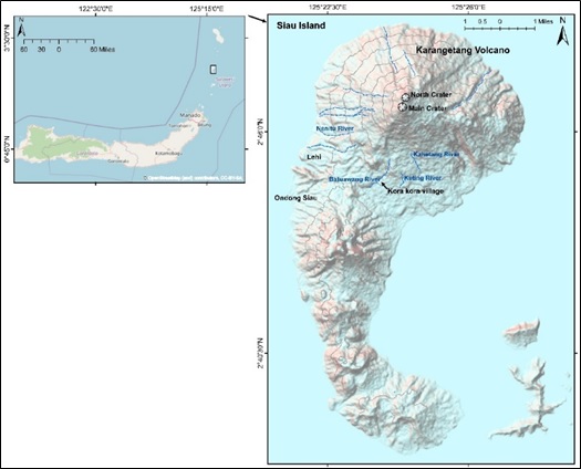
On May 7-9, 2015 the eruptive activity of Mount Karangetang released pyroclastic flows towards the Batuawang River for 3.6 km and hit Kora kora village which is located south of the Main Crater. This pyroclastic flow originated from lava flows during the effusive eruption period. MODIS satellite image hotspot data shows the lava flow extrusion rate and total volume at the peak began to increase since April 2015 and continued to show an increase until December 2015, with the estimated volume and lava extrusion rate on April 22, 2015 reaching 4.16x10⁶ m3 and 0.53 m3/s, respectively, and on December 9, 2015 the volume reached 1.67x10⁷ m3 with a lava extrusion rate of 1.97 m3/s. The results of field checks show that this pyroclastic flow is dominated by block and ash, and by using numerical simulations show the deflection of pyroclastic flow in accordance with the flow field of the Batuawang river, and the splash of pyroclastic flow towards Kora kora village in addition to the location adjacent to the river flow and also controlled by the narrowing of the river channel due to the accumulation of material in the flow field. A total of 8 numerical simulation cases have been carried out, and in our opinion with an input volume of 500 x103 m3 and a flow material friction of 0.5 is a case that corresponds to a flow event that reaches a distance of 3.6 km from the Main Crater. Taking into account the current activity conditions we used the same parameters to estimate the area that could be affected by pyroclastic flows in the future. Numerical simulation show that the pyroclastic flow traveled 5 km in a south-southwest direction from the top of the main crater.
Downloads
References
Baxter, P.J., Neri, A., Todesco, M., 1998. Physical Modelling and Human Survival in Pyroclastic Flows. Natural Hazards 17, 163–176.
BNPB, I., n.d. Gunung Karangetang Meletus, 465 Warga Sitaro Mengungsi [WWW Document]. BNPB.
Branney, M.J., Kokelaar, P., 2002. Pyroclastic Density Currents and the sedimentation of Ignimbrites, Journal of Chemical Information and Modeling.
Budianto, A., Kartadinata, M.N., Kusdaryanto, 2000. Geological Map of Karangetang Volcano, North Sulawesi.
Fisher, R.V., 1979. Models for pyroclastic surges and pyroclastic flows. Journal of Volcanology and Geothermal Research 6, 305–318.
Global Volcanism Program, Smithsonian Institution, Venzke, E., 2013. Volcanoes of the World, v.4.3.4.
Global Volcanism Program | Karangetang [WWW Document], n.d. . Smithsonian Institution | Global Volcanism Program.
Global Volcanism Program | Karangetang [WWW Document], n.d. . Smithsonian Institution | Global Volcanism Program.
Global Volcanism Program | Report on Karangetang (Indonesia) — January 2023 [WWW Document],
Global Volcanism Program | Report on Karangetang (Indonesia) — May 2018 [WWW Document], n.d.
Global Volcanism Program | Report on Karangetang (Indonesia) — May 2019 [WWW Document], n.d.
Harris, A.J.L., Ripepe, M., 2007. Regional earthquake as a trigger for enhanced volcanic activity: Evidence from MODIS thermal data. Geophys. Res. Lett. 34, L02304.
Itoh, H, Takahama, J., Takahashi, M., Miyamoto, K., 2000. Hazard estimation of the possible pyroclastic flow disasters using numerical simulation related to the 1994 activity at Merapi Volcano. Journal of Volcanology and Geothermal Research 100, 503–516.
Itoh, H., Takahama, J., Takahashi, M., Miyamoto, K., 2000. Hazard estimation of the possible pyroclastic flow disasters using numerical simulation related to the 1994 activity at Merapi Volcano. Journal of Volcanology and Geothermal Research.
Kanatani, K.I., 1984. Flow of granular materials on an inclined plane.
Kriswati, E., Alfianti, H., 2019. Estimasi Volume Lava G. Karangetang Dan G. Anak Krakatau Berdasarkan Metode Penginderaan Jauh. Bulletin of Volcanology and Geological Hazard 13.
Kusnadi, I., Wahyudi, Y., Ardiansyah, D., Banggur, W., 2020. Kajian Geokimia lava Gunung Karangetang. PROSIDING KOLOKIUM KAJIAN KEGUNUNGAPIAN 2019 1, 25–33.
Kusumadinata, K., Hadian, R., Hamidi, S., Reksowirogo, L.D., 1979. Data dasar gunungapi Indonesia.
Oppenheimer, C., Francis, P.W., Rothery, D.A., Carlton, R.W.T., Glaze, L.S., 1993. Infrared image analysis of volcanic thermal features: Láscar Volcano, Chile, 1984-1992. J. Geophys. Res. 98, 4269–4286.
Patria, C., Basuki, A., Tamaka, H., Kuswarno, 2015. Laporan Tanggap Darurat Karangetang Mei 2015.doc.
Pratomo, I., 2006. Klasifikasi gunung api aktif Indonesia, studi kasus dari beberapa letusan gunung api dalam sejarah. Indonesian Journal on Geoscience 1, 209–227.
Pusat Vulkanologi dan Mitigasi Bencana Geologi, 2014. Sejarah Erupsi Gunung Karangetang [WWW Document].
Rukmini, N.A., Sulistiyani, Shimomura, M., 2019. Numerical Simulation of Historical Pyroclastic Flows of Merapi (1994, 2001, and 2006 Eruptions). Journal of Disaster Research 14, 90–104.
Santoso, I., Ismanto, R.D., Chusnayah, F., Tjahjaningsih, A., Suwarsono, Vetrita, Y., 2022. Lava flow mapping Karangetang Volcano during 2019 eruption using Sentinel-2 Images and Random Forest model. IOP Conf. Ser.: Earth Environ. Sci. 1109, 012063.
Shimomura, M., Banggur, W.F.S., Loeqman, A., 2019a. Numerical Simulation of Pyroclastic Flow at Mt. Semeru in 2002. Journal of Disaster Research 14, 116–125.
Shimomura, M., Putra, R., Rukmini, N.A., Sulistiyani, 2019b. Numerical Simulation of Mt. Merapi Pyroclastic Flow in 2010. Journal of Disaster Research 14, 105–115.
Wright, R., Flynn, L.P., Garbeil, H., Harris, A.J.L., Pilger, E., 2004. MODVOLC: near-real-time thermal monitoring of global volcanism. Journal of Volcanology and Geothermal Research 135, 29–49.
Yamashita, S., Miyamoto, K., 1993. Model of pyroclastic flow and its numerical simulation.
Downloads
Published
Versions
- 2024-04-01 (2)
- 2024-03-28 (1)
Issue
Section
License
Copyright (c) 2024 Journal of Geoscience, Engineering, Environment, and Technology

This work is licensed under a Creative Commons Attribution-ShareAlike 4.0 International License.
Copyright @2019. This is an open-access article distributed under the terms of the Creative Commons Attribution-ShareAlike 4.0 International License which permits unrestricted use, distribution, and reproduction in any medium. Copyrights of all materials published in JGEET are freely available without charge to users or / institution. Users are allowed to read, download, copy, distribute, search, or link to full-text articles in this journal without asking by giving appropriate credit, provide a link to the license, and indicate if changes were made. All of the remix, transform, or build upon the material must distribute the contributions under the same license as the original.


