
Seismic Vulnerability Analysis Using the Horizontal to Vertical Spectral Ratio (HVSR) Method on the West Palu Bay Coastline
DOI:
https://doi.org/10.25299/jgeet.2023.8.02-2.13879Keywords:
Passive seismic, Microtremor, HVSR, Seismic vulnerability index, Peak ground acceleration, Palu-DonggalaAbstract
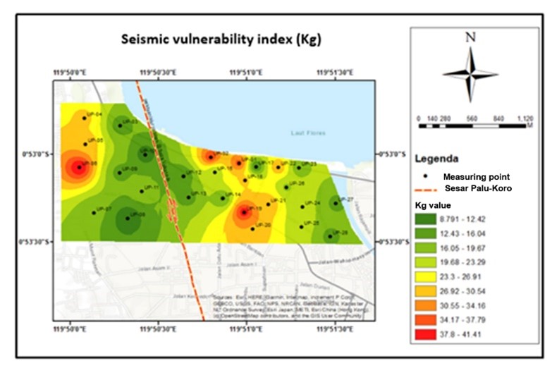
This research was carried out to make a map of the dominant frequency (f0), amplification factor (A0), seismic susceptibility index (Kg), Vs30, Sediment Layer Thickness (H) and Peak ground acceleration (PGA). Microtremor measurements were carried out with a three-component seismometer of the TDL-303S type as many as 27 measurement points. The data was analyzed by the Horizontal to Vertical Spectral Ratio (HVSR) method. The PGA calculation was carried out using the Kanai equation with a reference to the Palu-Donggala earthquake on September 28, 2018. The results showed that the distribution of the dominant frequency value (f0) ranged from 0.4149 Hz-0.8869 Hz, the soil amplification factor (A0) ranged from 2,199–4,884, the seismic vulnerability index (Kg) ranged from 8.79 s2/cm-41.41 s2/cm, the shear wave velocity to a depth of 30 meters ( Vs30) ranged from Vs30 197.7 m/s-320.2 m/s , the thickness of the sedimentary layer ranges from 260.3 m-291.1 m and the peak ground acceleration (PGA) of Kanai ranges from 137.3 gal – 234.2 gal by using Mw 7.4 earthquakes with an intensity scale (MMI) VI to VII. The coastal area of West Palu bay has an intermediate seismic vulnerability II to a high seismic vulnerability IV so that it will be vulnerable in the event of an earthquake disaster. Areas that have a very high vulnerability index are in the upper western and easternmost regions while those with a lower level tend to have a lower vulnerability index value.
Downloads
References
Allen, T. I., Wald, D. J. 2007, Topographic slope as a proxy for global seismic site conditions (VS 30) and amplification around the globe: U.S. Geological Survey Open-File Report 2007-1357, 69. https://doi.org/10.1785/0120060267
BMKG Kota Palu., 2018. Laporan Akhir Analisis Indeks Kerentanan Seismik Kota Palu. BMKG Kelas I Palu. Kota Palu.
Douglas., 2004, Ground Motion Estimation Equation 1964-2003, South Kensington Campus Press, London.
Geopsy Tutorial: H/V Measurement (Modified 2008-10-21) https://www.geopsy.org/documentation/geopsy/hv.html
Herak, M., 2008, ModelHVSR: a Matlab tool to model horizontal-to-vertical spectral ratio of ambient noise. Computers and Geosciences 34, 1514-1526. https://doi.org/10.1016/j.cageo.2007.07.009
Kanai, K., 1983, Seismology in Engineering, Tokyo University, Japan.
Kanai., 1966, Improved Empirical Formula for Characteristics of Stray Earthquake Motion. Proceedings of The Japanese Earthquake Symposium (1-4). Japan: Reported in Trifunac & Brandy (1975).
Nakamura, Y., 2008. On The H/V Spectrum, The 14th World Conference on Earthquake Engineering: Beijing, China.
Sambridge, M., 1999, Geophysical Inversion with a neighbourhood algorithm: I. Searching a parameter space. Geophysical Journal International 138, 479-494. https://doi.org/10.1046/j.1365-246X.1999.00876.x
SESAME., 2004, Guidelines for the Implementation of the H/V Spectral Ratio Technique on Ambient Vibratio Measurement, Processing and Interpretation, European Commission - Reseacrh General Directorate.
Wathelet, M., 2005, Array recordings of ambient vibrations: surface-wave inversion. PhD thesis Universite de Liege Belgium.
Wathelet, M., 2008, An improved neighborhood algorithm: parameter conditions and dynamic scaling. Geophysical Research Letters 35, L09301. https://doi.org/10.1029.2008GL033356.pdf
Downloads
Published
Issue
Section
License
Copyright @2019. This is an open-access article distributed under the terms of the Creative Commons Attribution-ShareAlike 4.0 International License which permits unrestricted use, distribution, and reproduction in any medium. Copyrights of all materials published in JGEET are freely available without charge to users or / institution. Users are allowed to read, download, copy, distribute, search, or link to full-text articles in this journal without asking by giving appropriate credit, provide a link to the license, and indicate if changes were made. All of the remix, transform, or build upon the material must distribute the contributions under the same license as the original.


