
An Application of HVSR Method on Microtremor Data for Analysis of Earthquake Potential in Candipuro District, Lumajang, Indonesia
DOI:
https://doi.org/10.25299/jgeet.2023.8.4.13460Keywords:
Microtremor, HVSR, GSS, Earthquake.Abstract
The Earthquake of 6.1 magnitude occurred on April 10, 2021, in Lumajang district. One affected area suffered building losses, road damage, and casualties in Candipuro District, Lumajang Regency, East Java. Then the research was conducted to determine the strength of the soil against the potential earthquake by micro zoning the area in Candipuro District. This research uses the microtremor method with HVSR (Horizontal to Vertical Spectral Ratio) analysis. Analysis of earthquake potential includes parameters of Ground Amplification (A0), Dominant Frequency (f0), Ground Vulnerability Index (Kg), and Ground Shear Strain (GSS).
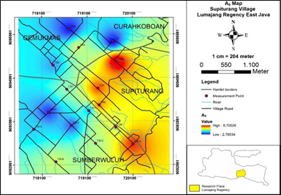
The acquisition was completed with 16 measurement points in Supiturang Village with 500 meters between points using the Portable Seismograph TDS - 303. The results obtained in Supiturang Village have the results of the amplification value factor which is classified as medium-high (2.7 - 8.7), low dominant frequency value (0.5 - 1.4 Hz), medium-high soil susceptibility index (10 - 90), VS30 value which includes medium - hard soil (187.81 - 548.38) m/s, and GSS value which shows the response of cracks and soil subsidence to shaking (2 x 10⁻⁵ - 2 x 10⁻⁴).
Downloads
References
Anonim. (12 April, 2021). Gempa 6.1 Kabupaten Lumajang. BPBD Lumajang.
Arifin, S. S., Mulyatno, B. S., Marjiyono, & Setianegara, R. (2014). PENENTUAN ZONA RAWAN GUNCANGAN BENCANA GEMPA BUMI BERDASARKAN ANALISIS NILAI AMPLIFIKASI HVSR MIKROTREMOR DAN ANALISIS PERIODE DOMINAN DAERAH LIWA DAN SEKITARNYA. Jurnal Geofisika Eksplorasi, 2, 30–40.
Fadhilah, U., Budi Wibowo, N., Darmawan, D., Negeri Yogyakarta, U., & Meteorologi Klimatologi dan Geofisika Yogyakarta, B. (2017). Microzonation Of Seismic Vulnerability Index At Grindulu Fault Line Area In Pacitan Regency Based On Microtremor Data.
Fatimah, R., Ardianto, T., & Qomariyah, N. (2019). Mikrozonasi Gempabumi di Desa Medana dan Jenggala Kecamatan Tanjung Kabupaten Lombok Utara Menggunakan Metode Mikroseismik. Indonesian Physical Review, 2(1).
Fauzatun Wachidah dan Ninik Agustin, S. (2021). Analisa Kerentanan Tanah Di Kecamatan Adipala Kabupaten Cilacap Menggunakan Metode Mikrotremor Sebagai Upaya Mitigasi Bencana Gempa Bumi (Vol. 24, Issue 1).
Haerudin, N., Rustadi, and Fitriawan, H., 2019. Earthquake Disaster Mitigation Mapping by Modeling of Land Layer and Site Effect Zone in The Kota Baru of South Lampung. Jurnal Pendidikan Al Biruni No. 8. Vol 1 2019.
Hariansyah, R., Katriani, L., Darmawan, D., & B Wibowo, dan N. (2020). SEMINAR NASIONAL FISIKA (SNF)
Analisis mikrotremor pada kawasan dugaan jalur sesar lokal di Kabupaten Klaten, Jawa Tengah.
Igan S Sutawidjaja, D. Wahyudin, and E. Kusnidar. 1996. Peta Geologi Gunung Semeru, Jawa Timur. Bandung: Direktorat Vulkanologi
Mufida et al. 2013."Profiling Kecepatan Gelombang Geser Vs Surabaya Berdasarkan Pengolahan Data Mikrotremor", Jurnal Sains Dan Seni Pomits, Vol.2.
Nakamura, Y. 1989. A Method for Dynamic Characteristic Estimation of Subsurface using Microtremor on The Ground Surface. Q.R. of RTRI. Vol.30, No. 1, page 25-33.
Nakamura, Y. 1997. Seismic Vulnerability Indices for Ground and Structures using Microtremor. World Congress on Railway Research: Florence.
Nakamura, Y. 2000. Clear Identification of Fundamental Idea of Nakamura’s Technique and Its Application. The 12nd Word Conference on Earthquake Engineering. Tokyo, Japan
Nakamura, Y. 2008. On The H/V Spectrum. The 14th World Conference on Earthquake Engineering. Beijing, China.
Nurwidyanto, M. I., Zainuri, M., Wirasatrya, A., & Yuliyanto, G. (2023). Struktur Bawah Permukaan Pantai Semarang berdasarkan Metode HVSR. INDONESIAN JOURNAL OF APPLIED PHYSICS, 13(1), 117.
Permana, M. A., & Faisal, M. (2023). Uji Performa Prediksi Gempa Bumi di Jawa Timur dengan Artificial Neural Network. Euler : Jurnal Ilmiah Matematika, Sains Dan Teknologi, 11(1), 44–54.
Reza Iswara, M., & Hardy, T. (2020). Analysis Of Ground Shear Strain (GSS) District Kawalu Tasikmalaya With HVSR Method Using Microtremor Data. 150(2),150–155.
Risa, I. N., Maison, M., & Dewi, I. K. (2023). ANALISIS KERENTANAN TANAH BERDASARKAN PENGUKURAN MIKROTREMOR DI DESA JATI MULYO, TANJUNG JABUNG TIMUR. JGE (Jurnal Geofisika Eksplorasi), 9(1), 18–31.
Rochman, J. P. G. N., Sadewa, M. A., & Putra, A. M. (2023). Earthquake Microzonation Using Microtremor Analysis and Horizontal to Vertical Spectral Ratio Method Study Case at Ampelgading and Tirtoyudo Sub-district, Malang, East Java (pp. 127–136).
SNI 1726. 2019. Tata Cara Perencanaan Ketahanan Gempa untuk Struktur Bangunan Gedung dan Non Gedung. Jakarta : Badan Standarisasi Nasional
Syahputri, A., & Sismanto, S. (2020). Identifikasi Potensi Tanah Longsor Menggunakan Metode Mikrotremor Di Dusun Tegalsari Desa Ngargosari Kecamatan Samigaluh Kabupaten Kulon Progo. Jurnal Fisika Indonesia, 24(2), 66.
Downloads
Published
Issue
Section
License
Copyright (c) 2023 Journal of Geoscience, Engineering, Environment, and Technology

This work is licensed under a Creative Commons Attribution-ShareAlike 4.0 International License.
Copyright @2019. This is an open-access article distributed under the terms of the Creative Commons Attribution-ShareAlike 4.0 International License which permits unrestricted use, distribution, and reproduction in any medium. Copyrights of all materials published in JGEET are freely available without charge to users or / institution. Users are allowed to read, download, copy, distribute, search, or link to full-text articles in this journal without asking by giving appropriate credit, provide a link to the license, and indicate if changes were made. All of the remix, transform, or build upon the material must distribute the contributions under the same license as the original.


