
Investigation of Groundwater Quality using Vertical Electrical Sounding and Dar Zarrouk Parameter in Leihitu, Maluku, Indonesia
DOI:
https://doi.org/10.25299/jgeet.2023.8.3.12976Keywords:
Dar Zarrouk Parameter, Groundwater, Leihitu District, Resistivity, VESAbstract
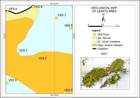
The goal of this research is to obtain information related to aquifer quality, including aquifer protection capacity, transmissivity, and aquifer thickness based on vertical electrical sounding (VES) data and Dar-Zarrouk parameter analysis. The research area is located in Leihitu District, Ambon with 8 measurement points. The Leihitu region is included in the geological map of the Ambon sheet, Maluku, which consists of Late Pliocene - Holocene lithology, specifically Ambon volcanic rocks, reef limestones, and alluvial deposits. The rock resistivity measurements and layer thickness information were obtained using the VES method and analyzed with IP2WIN software. Based on VES data, aquifer properties were identified using Dar-Zarrouk parameters. That parameter consisted of longitudinal conductance, transfer resistance, longitudinal resistivity, and transfer resistivity. Longitudinal unit conductance is applied to evaluate the protective capacity class of the aquifer, the transfer resistance is beneficial for analyzing rock type and aquifer transmissivity. Based on the Dark-Zarrouk parameters, the longitudinal conductance (S) ranged from 0.0278 to 5.1213 mho and was classified as moderate to good protective capacity. The high S value results from a thick layer of clay at the observation point. This area also has a high enough transverse resistance (T) and then if related to aquifer transmissivity, this area is classified as a good transmissivity aquifer, especially at VES 2, VES 5, VES 6, VES 7, and VES 8. If correlated to rock formations, areas with limestone and volcanic rocks have better transmissivity than areas with alluvial deposits.
Downloads
References
Abd-Elhamid, H., Abdelaty, I., & Sherif, M. (2019). Evaluation of potential impact of Grand Ethiopian Renaissance Dam on Seawater Intrusion in the Nile Delta Aquifer. International Journal of Environmental Science and Technology, 16(5), 2321–2332.
Abd-Elhamid, H., Javadi, A., Abdelaty, I., & Sherif, M. (2016). Simulation of seawater intrusion in the Nile Delta aquifer under the conditions of climate change. Hydrology Research, 47(6), 1198–1210.
Ahamefula, U. U., Benard, I. O., & Anthony, U. O. (2012). Estimation of Aquifer Transmissivity Using Dar Zarrouk Parameters Derived from Surface Resistivity Measurements: A Case History from Parts of Enugu Town (Nigeria). Journal of Water Resource and Protection, 4(December), 993–1000.
Alhumimidi, M. S. (2020). Journal of King Saud University – Science An integrated approach for identification of seawater intrusion in coastal region : A case study of northwestern Saudi Arabia. Journal of King Saud University - Science, 32(7), 3187–3194.
Bahri, S., Aponno, S. V., & Zulfiah. (2022). Global Optimization Very Fast Simulated Annealing Inversion For The Interpretation of Groundwater Potential. Jurnal Geofisika Eksplorasi, 08(03), 225–236.
Bayewu, O. O., Oloruntola, M. O., Mosuro, G. O., Laniyan, T. A., Ariyo, S. O., & Fatoba, J. O. (2018). Assessment of groundwater prospect and aquifer protective capacity using resistivity method in Olabisi Onabanjo University campus, Ago-Iwoye, Southwestern Nigeria. NRIAG Journal of Astronomy and Geophysics, 7(2), 347–360.
Djunarsjah, E., & Putra, A. P. (2021). The concept of an archipelagic Province in Indonesia. IOP Conf. Series: Earth and Environmental Sciences, 012040.
Domenico, P. A., & Schwartz, F. A. (1998). Physical and chemical hydrogeology (2nd ed.). John Wiley & Sons Inc.
Ekwok, S. E., Ben, U. C., Eldosouky, A. M., Qaysi, S., Akpan, A. E., & Andráš, P. (2022). Towards understanding the extent of saltwater incursion into the coastal aquifers of Akwa Ibom State , Southern Nigeria using 2D ERT. Journal of King Saud University - Science, 34(8), 102371.
Everett, M. E. (2013). Near Surface Applied Geophysics. Cambridge University Press.
Ezekiel, T., & Lasisi, K. H. (2020). Seawater intrusion in the coastal aquifers of East and Horn of Africa : A review from a regional perspective. Scientific African, 8, e00402.
Folorunso, A. F. (2021). Mapping a spatial salinity flow from seawater to groundwater using electrical resistivity topography techniques. Scientific African, 13, e00957.
Gao, Q., Shang, Y., Hasan, M., Jin, W., & Yang, P. (2018). Evaluation of a weathered rock aquifer using ERT method in South Guangdong, China. Water (Switzerland), 10(3), 1–22.
Hasan, M., Shang, Y., Akhter, G., & Jin, W. (2020). Delineation of contaminated aquifers using integrated geophysical methods in Northeast Punjab, Pakistan. Environmental Monitoring and Assessment, 192(12), 1–15.
Holmes, J., Chambers, J., Wilkinson, P., Dashwood, B., Gunn, D., Kirkham, M., Uhlemann, S., Meldrum, P., Kuras, O., Huntley, D., Abbott, S., Sivakumar, V., & Donohue, S. (2022). 4D electrical resistivity tomography for assessing the influence of vegetation and subsurface moisture on railway cutting condition. Engineering Geology, 307(106790), 1–13.
Honthaas, C., Maury, R. C., Priadi, B., Bellon, H., & Cotten, J. (1999). The Plio-Quaternary Ambon arc, Eastern Indonesia. Tectonophysics, 301(3–4), 261–281.
Kazakis, N., Pavlou, A., Vargemezis, G., Voudouris, K. S., Soulios, G., Pliakas, F., & Tsokas, G. (2016). Seawater intrusion mapping using electrical resistivity tomography and hydrochemical data. An application in the coastal area of eastern Thermaikos Gulf, Greece. Science of the Total Environment, 543, 373–387.
Koefoed, O. (1979). Geosounding Principles, 1: Resistivity Sounding Measurements (1st ed.). Elsevier Publishing Company.
Mahmud, S., Hamza, S., Irfan, M., Huda, S. N., Burke, F., & Qadir, A. (2022). Groundwater for Sustainable Development Investigation of groundwater resources using electrical resistivity sounding and Dar Zarrouk parameters for Uthal Balochistan , Pakistan. Groundwater for Sustainable Development, 17(September 2021), 100738.
Maillet, R. (1947). The fundamental equation of electrical prospecting. Geophysics, 12(4), 529–556.
Martínez, J., Benavente, J., García-aróstegui, J. L., Hidalgo, M. C., & Rey, J. (2009). Contribution of electrical resistivity tomography to the study of detrital aquifers affected by seawater intrusion – extrusion effects : The river Vélez delta ( Vélez-Málaga , southern Spain ). Engineering Geology, 108(3–4), 161–168.
Miharja, M., & Arsallia, S. (2017). Integrated Coastal Zone Planning Based on Environment Carrying Capacity Analysis. IOP Conference Series: Earth and Environmental Science, 79(1).
Moore, W. S., & Joye, S. B. (2021). Saltwater Intrusion and Submarine Groundwater Discharge: Acceleration of Biogeochemical Reactions in Changing Coastal Aquifers. Frontiers in Earth Science, 9(April), 1–14.
Mukate, S. V., Panaskar, D. B., Wagh, V. M., & Baker, S. J. (2019). Understanding the influence of industrial and agricultural land uses on groundwater quality in semiarid region. In Environment, Development and Sustainability. Springer Netherlands.
Obakhume, K. A. (2022). Integrated geophysical characterization of saltwater intrusion in Lagos State , Eastern Dahomey Basin , Southwestern Nigeria. Scientific African, 16, e01251.
Odalapo, M. I., & Akintorinwa, O. J. (2007). Hydrogeophysical study of Ogbese South western, Nigeria. Global Journal of Pure and Applied Sciences, 13(1), 55–61.
Patil, S. N., Kachate, N. R., & Ingle, S. T. (2018). Estimation of Dar-Zarrouk parameters for groundwater exploration in parts of Chopda Taluka, Jalgaon district, Maharashtra (India). Journal Indian Geophysics Union, 22(4), 425–435.
Porras, D., Carrasco, J., Carrasco, P., & Gonz, P. J. (2022). Imaging extensional fault systems using deep electrical resistivity tomography : A case study of the Baza fault , Betic Cordillera , Spain. Journal of Applied Geophysics, 202(104673), 1–13.
Pownall, J. M., Hall, R., & Watkinson, I. M. (2013). Extreme extension across Seram and Ambon , eastern Indonesia : evidence for Banda slab rollback. Solid Earth, 4, 277–314.
Shinawi, A. El, Kuriqi, A., Zelenakova, M., Vranayova, Z., & Abd-Elaty, I. (2022). Land subsidence and environmental threats in coastal aquifers under sea level rise and over-pumping stress. Journal of Hydrology, 608(November 2021), 127607.
Singh, U. K., Das, R. ., & Hodlur, G. . (2004). Significance of Dar-Zarrouk parameters in the exploration of quality affected coastal aquifer systems. Environmental Geology, 45, 696–702.
Sukrisno. (1994). Hydrogeological map of Indonesia. Direktorat Geologi Tata Lingkungan.
Tahama, K., Baride, A., Gupta, G., Erram, V. C., & Baride, M. V. (2022). HydroResearch Spatial variation of sub-surface heterogenieties within the dyke swarm of Nandurbar region ,Maharashtra , India , for groundwater exploration using Inverse Distance Weighted technique. HydroResearch, 5, 1–12.
Tjokrosaputro, S., Rusmana, E., & Achdan, A. (1993). Peta geologi lembar ambon, maluku. Pusat penelitian dan pengembangan geologi.
Wilopo, W., Risanti, Susanto, R., & Putra, D. P. E. (2018). Seawater intrusion assesment and prediction of sea-freshwater interface in Parangtritis coastal aquifer, South of Yogyakarta Special Province. J. Degrade. Min. Land Manage, 8(3), 2709–2718.
Downloads
Published
Issue
Section
License
Copyright @2019. This is an open-access article distributed under the terms of the Creative Commons Attribution-ShareAlike 4.0 International License which permits unrestricted use, distribution, and reproduction in any medium. Copyrights of all materials published in JGEET are freely available without charge to users or / institution. Users are allowed to read, download, copy, distribute, search, or link to full-text articles in this journal without asking by giving appropriate credit, provide a link to the license, and indicate if changes were made. All of the remix, transform, or build upon the material must distribute the contributions under the same license as the original.


