
Study of Coastal Morphological Changes by Tsunamis in Aceh (Indonesia) Using Satellite Images
DOI:
https://doi.org/10.25299/jgeet.2023.8.4.12757Keywords:
Coastal morphological changes, Shoreline change, Tsunamis, DSAS analysisAbstract
This study identified the coastal morphological changes caused by tsunamis that occurred in Banda Aceh, Lampuuk-Lhoknga, and Meulaboh. The morphology of study areas was drastic changes during the 2004 tsunami and followed by the 2005, 2010, and 2012 tsunamis. Time series of Landsat satellite images and tidal data were collected during the period 1988-2020 and analyzed using DSAS (Digital Shoreline Analysis System) analysis method. The main aim of this study is to monitor recovery, trend development, and controlling factors of the coastal morphology before and after fifteen years of the 2004 tsunami.
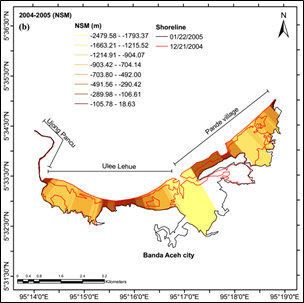
In Banda Aceh, the shoreline shift in the 2004-2005 period shows an inland retreat trend, with an average NSM (net shoreline movement) value of -644.69 m. The EPR (end point rate) value for the 2005-2020 period reached 21.31 m/year, but the recovery of the 2020 shoreline position has not returned to the original position before the 2004 tsunami. The significant shoreline retreat and land loss with an average NSM value of -40.59 m in the period 2004-2005 occurred on the Lampuuk and Lhoknga beaches. The 2020 shoreline of Lampuuk beach underwent a recovery with accretion. Nevertheless, Lhoknga beach is still experiencing apparent erosion. The recovery of the Meulaboh east coast was fast as evidenced by the development of the annual growth of spit features. The coastal morphological changes are influenced by complex interactions between natural and anthropogenic processes. The 2004 tsunami was the major factor to change the coastal morphology in the study areas.
Downloads
References
Adela, I., Nugraha, G.S., Irham, M., Syahreza, S., 2018. Spatial Analysis of Post-Tsunami 2004 Coastline Changes in Lampuuk, Aceh Besar. IOP Conf. Series: Earth and Environmental Science 273 012046.
Alesheikh, AA., Ghorbanali, A., Nouri, N., 2007. Coastline Change Detection Using Remote Sensing. International Journal of Environment Science and Technology. 4 (1): 61-66.
Borrero, J. C., 2005. Field Data and Satellite Imagery Tsunami Effects in Banda Aceh. Science, Vol: 308, 1596.
Chen, P., Liew, S. C., Kwoh, L. K., 2005. Tsunami Damage Assessment Using High-Resolution Satellite Imagery: A Case Study of Aceh, Indonesia. Paper presented at the IEEE International Geoscience and Remote Sensing Symposium 2005, 25e29 July 2005, Seoul, Korea.
Claire et al., 2012. Remote Sensing Application For Coastline Detection In Ca Mau, Mekong Delta. International Symposium on Geoinformatics for Spatial Infrastructure Development in Earth and Allied Sciences.
Crowell, M., and S. P. Leatherman., 1999. Coastal Erosion Mapping and Measurement. Journal of Coastal Research 28: 1–196.
Fan D., Nguyen Dac Ve., Su Jianfeng, Van Bui Vuong., and Lan Tran Dinh., 2019. Coastal Morphological Changes in the Red River Delta under Increasing Natural and Anthropic Stress. Canadian Science Publishing: Anthropocene Coasts 2: 51-71.
Griffin, C., Ellis, D., Beavis, S., and Zoleta-Nantes, D., 2012. Coastal Resources, Livelihoods and the 2004 Indian Ocean Tsunami in Aceh, Indonesia. Ocean and Coastal Management, 71, 176-186.
Himmelstoss, E.A., Henderson, R.E., Kratzmann, M.G., Farris, A.S., 2018. Coastal Shoreline Analysis System (DSAS) Version 5.0 User Guide. U.S Geological Survey Open File Report 2018-1179,110p.
IPCC (Intergovernmental Panel on Climate Change)., 2007. Climate Change 2007: The Physical Science Basis. Contribution of Working Group I to the Fourth Assessment Report of the Intergovernmental Panel on Climate Change. Cambridge University Press, Cambridge, UK.
Irham, M., Suri, R., Setiawan, I., and Faudi, A., 2021. Spatial Analysis of Accretion, Abrasion, and Shoreline Change in Banda Aceh Coastal Area. IOP Conf. Series: Earth and Environmental Science. 674, 012046.
King, C.A.M., 1972. Beaches and coasts. (2nd ed.). London: Edward Arnold. Pp. 151-161.
Kumar, A., Naraya, A.C., Jayappa, K.S., 2010. Shoreline changes and morphology of spits along with southern Karnataka, west coast of India: A remote sensing and statistics-based approach. Elsevier: Geomorphology 120, 133-152.
Li, R., K. Di, and R. Ma., 2003. 3-D shoreline Extraction from IKONOS Satellite Imagery. Marine Geodesy 26(1–2): 107–115.
Liew, S. C., Gupta, A., Wong, P. P., Kwoh, L. K., 2010. Recovery from a Large Tsunami Mapped Over Time: The Aceh Coast, Sumatra. Geomorphology 114(4):520–529.
Meilianda, E., Dohmen-Janssen, C., Maathuis, B., Hulscher S., Mulder, J., 2010. Short-term Morphological Responses and Developments of Banda Aceh Coast, Sumatra Island, Indonesia After the Tsunami on 26 December 2004. Marine Geology, 275 (1): 96–109.
Meilianda, E., Pradhan, B., Syamsidik, Comfort, L.K., Alfian, D., Juanda R., Syahreza, S., Munadi, K., 2019. Assessment of Post-tsunami Disaster Land Use/Land Cover Change and Potential Impact of Future Sea-Level Rise to Low Laying Coastal Areas: A case study of Banda Aceh Coast of Indonesia. Elsevier.
Monecke, K., Finger, W., Klarer, D., Kongko, W., McAdoo, B.G., Moore, A.L., Sudrajat, S.U., 2008. A 1000-year Sediment Record of Tsunami Recurrence in Northern Sumatra. Nature 455, 1232–1234.
Nguyen An Thint and Luc Hens., 2017. A Digital Shoreline Analysis System (DSAS) Applied on Mangrove Shoreline Changes along the Giao Thuy Coastal Area (Nam Dinh, Vietnam) during 2005-2014. Vietnam Journal of Earth Sciences, 39(1), 87-96.
Nugroho, H. S., 2013. Analisa Perubahan Garis Pantai Akibat Gempa dan Tsunami di Pesisir Meulaboh, Nanggroe Aceh Darussalam. Oseana, Vol: XXXVIII, No 1, Tahun 2013: 63-74.
Pardo-Pascual JE, Almonacid-Caballer J, Ruiz LA, Palomar Vázquez J., 2012. Automatic Extraction of Shorelines from Landsat TM and ETM Multi-temporal Images with Subpixel Precision. Remote Sensing of Environment 123:1–11.
Paris, R., Lavigne, F., Wassmer, P., Sartohadi, J., 2007. Coastal Sedimentation Associated with the December 26, 2004 Tsunami in Lhok Nga, West Banda Aceh (Sumatra, Indonesia). Elsevier: Marine Geology 238, 93–106.
Rasyif, T.M., Kato, S., Syamsidik, and Okabe, T., 2019. Numerical Simulation of Morphological Changes due to the 2004 Tsunami are around Banda Aceh, Indonesia. Geosciences, 9(3): 125.
Subarya. C., Chileh, M., Prawirodirdjo, L., Avouac, J-P., Bock, Y., Sieh, K., 2006. Plate Boundary Deformation Associated with the Great Sumatra-Andaman Earthquake. Nature 440, 46-51.
Suhana, M.P., 2016. Analisis Perubahan Garis Pantai di Pantai Timur Pulau Bintan Provinsi Kepulauan Riau. Institut Pertanian Bogor. (dissertation).
Stanica, A and Ungureanu, V.G., 2010. Understanding Coastal Morphology and Sedimentology. Near Curriculum in Naural Environmental Science, Tere et Environnement, Vol. 88, 105-111.
Syamsidik, Iskandar, A., Rasyif, T. M., 2015. Progress of Coastal Line Rehabilitation After the Indian Ocean Tsunami Around Banda Aceh Coasts. Springer Japan: R. Shaw (ed), Recovery from the Indian Ocean Tsunami: A Ten-Years Journey, Disaster Risk Reduction.
Syamsidik, Fahmi, M., Al’ala, M., Tursina., 2016. Tsunami Wave Impacts on Coastal Morphological Changes and One-Decade Process of Coastal Line Recovery after the 2004 Indian Ocean Tsunami around Banda Aceh, Indonesia. International Ocean and Polar Engineering Conference Rhodes, Greece. ISBN 978-1 880653-88-3; ISSN 1098-6189.
White, K., and El Asmar, H.M., 1999. Monitoring Changing the Position of Coastlines Using Thematic Mapper Imagery, an Example from the Nile Delta. Geomorphology, 29: 93–105.
Winarso, G., Judijanto, Budhiman, S., 2001. The Potential Application of Remote Sensing Data for the Coastal Study. Paper presented at the 22nd Asian Conference on Remote Sensing.
Downloads
Published
Issue
Section
License
Copyright (c) 2023 Journal of Geoscience, Engineering, Environment, and Technology

This work is licensed under a Creative Commons Attribution-ShareAlike 4.0 International License.
Copyright @2019. This is an open-access article distributed under the terms of the Creative Commons Attribution-ShareAlike 4.0 International License which permits unrestricted use, distribution, and reproduction in any medium. Copyrights of all materials published in JGEET are freely available without charge to users or / institution. Users are allowed to read, download, copy, distribute, search, or link to full-text articles in this journal without asking by giving appropriate credit, provide a link to the license, and indicate if changes were made. All of the remix, transform, or build upon the material must distribute the contributions under the same license as the original.


