
Identifying Dominant Structural Pattern of Semarang City Using Digital Elevation Model and Landsat 8-OLI Imagery
DOI:
https://doi.org/10.25299/jgeet.2024.9.1.12706Keywords:
fault fracture density, lineament, fault zone, lithology, SemarangAbstract
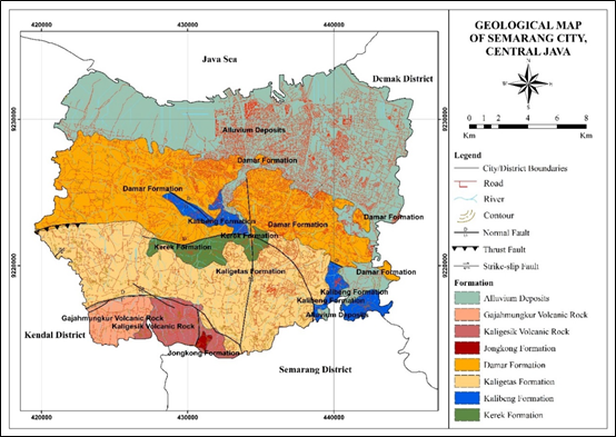
Semarang City is an area in the northern part of Java Island, administratively the Capital of Central Java Province. Because Semarang City is the provincial capital, Semarang City has a relatively dense population. Geologically, the city of Semarang is an area that consists of various types of lithology and is traversed by various regional geological structures. In this case, understanding the existence and distribution of geological structures in the city of Semarang is essential, considering that geological structures are one of the controllers for natural disasters such as landslides and earthquakes. This study analyzed the existence and distribution of geological structures in the city of Semarang based on the lineaments observed from digital elevation models and satellite imagery. This study aims to identify the dominant structural pattern in Semarang City, determine the relationship between fault fracture density (FFD) with regional geological structure and lithology, and determine the fault zone area in Semarang City based on FFD & lineament analysis. The method used in this analysis is to process DEM data and Landsat 8-OLI imagery, then interpret the lineaments in the form of rosset diagrams and the density in the form of FFD maps. The results of the rosset diagram analysis show that Semarang City has various structural lineament patterns, namely: North–South, Northeast–Southwest, and Northwest–Southeast, with the North–South pattern as the dominant pattern. Based on the results of the lineament density distribution on the FFD map, it is known that the area traversed by the Semarang regional geological structure has a high lineament density value which is interpreted that the area is a weak zone with high structural intensity. From this study, it can also be seen that there is no significant relationship between the type of lithology and the density value on the FFD map. The distribution of lineament density is not affected by the type of lithology, except in the northern and northeastern parts of Semarang city, which consist of alluvium. Based on these results, it can be interpreted that the fault zone area is associated with areas that have high-density values on the FFD map. Distribution of the fault zone area of Semarang City is spreading over the Banyumanik, Gunungpati, and Mijen Districts, which are relatively in the southern and central parts of Semarang City.
Downloads
References
Budhitrisna, T., 1992. Peta Geologi Skala 1: 100.000 Lembar Salatiga, Jawa Tengah. Pusat Penelitian dan Pengembangan Geologi, Bandung.
Caine, J.S., Evans, J.P. and Forster, C.B., 1996. Fault zone architecture and permeability structure. Geology, 24(11), pp.1025-1028.
Han, L., Liu, Z., Ning, Y. and Zhao, Z., 2018. Extraction and analysis of geological lineaments combining a DEM and remote sensing images from the northern Baoji loess area. Advances in Space Research, 62(9), pp.2480-2493.
Helmy, M., 2008. Kajian geologi dan neotektonik untuk melaraskan program pembangunan di wilayah Kota Semarang, Jawa Tengah. Laporan Penelitian Hibah Bersaing, UPN Veteran Yogyakarta (Tidak diterbitkan).
Hidayat, E., 2013. Identifikasi sesar aktif di sepanjang jalur kali garang, semarang. Jurnal Geologi dan Sumberdaya Mineral 23, 31–37.
Liu, J.G. and Mason, P.J., 2016. Image processing and GIS for remote sensing: techniques and applications. John Wiley & Sons.
Lumbanbatu, U.M., 2009. Perkembangan Dataran Pantai (Coastal Plain) Daerah Kendal Provinsi Jawa Tengah. Jurnal Geologi dan Sumberdaya Mineral, 19(4), pp.225-237.
Majumdar, T.J., Bhattacharya, B.B., 1988. Application of the Haar transform for extraction of linear and anomalous patterns over part of Cambay Basin, India. Int J Remote Sens 9, 1937–1942.
Nugraha, P., Supriyadi, S., Yulianti, I., 2016. Pendugaan Struktur Bawah Permukaan Kota Semarang Berdasarkan Data Anomali Gravitasi Citra Satelit. Unnes Physics Journal 5, 37–41.
Nurwidyanto, M.I., Yulianto, T., Widada, S., 2019. Modeling of semarang fault zone using gravity method, in: Journal of Physics: Conference Series. IOP Publishing, p. 012031.
Poedjoprajitno, S., Wahyudiono, J., Cita, A., 2008. Reaktivitas Sesar Kaligarang, Semarang. Indonesian Journal on Geoscience 3, 129–138.
Pramumijoyo, S., 2000. Existing active fault at Semarang, Central Java, Indonesia: revealed by remote sensing and field observation. In Proceedings of the HOKUDAN International Symposium and School on Active Faulting, Hyogo, Japan, h (pp. 383-385).
Putro, C.W., 2013. Pemetaan Geologi Struktur Untuk Menentukan Gambaran Tektonik Daerah Kawengen Dan Sekitarnya, Kecamatan Ungaran Timur, Kabupaten Semarang. Geological Engineering E-Journal, 5(1), pp.29-40.
Sunan, H.L., Gibran, A.K., Aditama, M.R., Iswahyudi, S., Widiatmoko, F.R., Widagdo, A. and Laksono, F.A.T., 2021. Interpretasi Struktur Geologi Berdasarkan Fault Fracture Density (FFD) dan Implikasinya Terhadap Potensi Likuefaksi di Daerah
Thanden, R.E., Sumadirdja, H., PW, R., 1996. PETA GEOLOGI LEMBAR MAGELANG DAN SEMARANG, JAWA. SKALA 1: 100000. Pusat Survei Geologi.
Thannoun, R.G., 2013. Automatic extraction and geospatial analysis of lineaments and their tectonic significance in some areas of Northern Iraq using remote sensing techniques and GIS. International Journal Of Enhanced Research In Science Technology & Engineering Bulletin, 2(2), pp.1-11.
Vassilas, N., Perantonis, S., Charou, E., Tsenoglou, T., Stefouli, M., Varoufakis, S., 2002. Delineation o
f lineaments from satellite data based on efficient neural network and pattern recognition techniques, in: Proc. Second Hellenic Conference on AI. Citeseer, pp. 355–365.
Wardhana, D.D., Harjono, H., Sudaryanto, S., 2014. Struktur bawah permukaan Kota Semarang berdasarkan data gayaberat. Riset Geologi dan Pertambangan-Geology and Mining Research 24, 53–64.
Widiatmoko, F.R., Putri, R.H.K. and Sunan, H.L., 2021. The Relation of Fault Fracture Density with the Residual Gravity; case study in Muria. Journal of Earth and Marine Technology (JEMT), 1(2), pp.105-110.
Downloads
Published
Issue
Section
License
Copyright (c) 2024 Journal of Geoscience, Engineering, Environment, and Technology

This work is licensed under a Creative Commons Attribution-ShareAlike 4.0 International License.
Copyright @2019. This is an open-access article distributed under the terms of the Creative Commons Attribution-ShareAlike 4.0 International License which permits unrestricted use, distribution, and reproduction in any medium. Copyrights of all materials published in JGEET are freely available without charge to users or / institution. Users are allowed to read, download, copy, distribute, search, or link to full-text articles in this journal without asking by giving appropriate credit, provide a link to the license, and indicate if changes were made. All of the remix, transform, or build upon the material must distribute the contributions under the same license as the original.


