
Identification Of Shear Strain On The Surface Ground Of Wangi-Wangi Island, Southeast Sulawesi, Indonesia, Using Nakamura’s Technique and The Possibility Of Its Impacts
DOI:
https://doi.org/10.25299/jgeet.2023.8.4.11780Keywords:
Shear strain, Nakamura’s technique, PGA, Microtremor, HVSR, GSS, Earthquake., Ground Vibration SignalAbstract
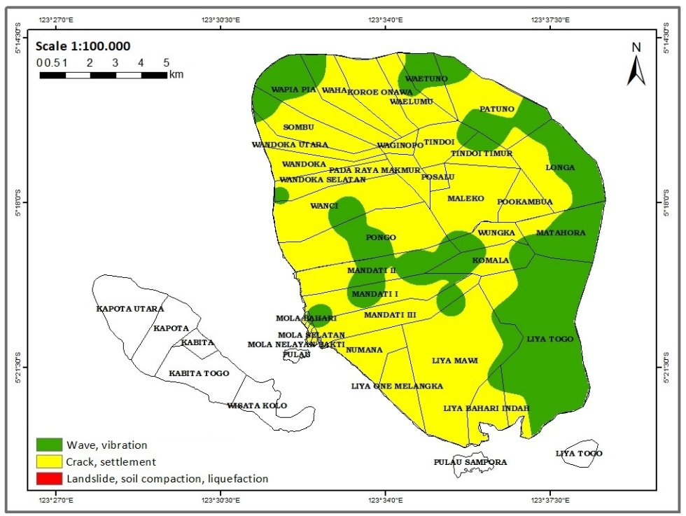
This research was conducted to determine the possible impact of an earthquake on the mainland of Wangi-Wangi Island based on the presence of shear strain on the surface ground (γ). The size of γ is obtained by multiplying the ground susceptibility index and the acceleration of basement ground or PGA using Nakamura’s technique. The data used are microtremor data and earthquake data from 1920 to 2020 sourced from the USGS. Microtremor data are obtained from the results of filtering ground vibration signals using a Band Pass Filter in the frequency range between 0.5 to 25 Hz. Ground vibration signals were recorded at 47 measurement points spread over the surface of Wangi-Wangi Island within 29.25 to 48.16 minutes. Furthermore, the microtremor data were processed using the HVSR (Horizontal to Vertical Spectral Ratio) method. The use of earthquake data must meet the requirements for a surface magnitude (MS) ≥ 5.0 SR and an earthquake epicenter depth (h) ≤ 45 km. The results obtained are the γ sizes of Wangi-Wangi Island in the order of 10-06 to 10-03. Based on the size distribution, it is known that the majority of the Wangi-Wangi Island area has the potential to experience cracks and land subsidence due to settlements if an earthquake occurs, and only a portion of the area is vibrating. In addition, it is also known that the mainland of Wangi-Wangi Island is not prone to landslides and liquefaction because γ<10-2.
Downloads
References
Arintalofa, V., Yuliyanto, G., and Harmoko, U., 2020. Subsurface characterization of Diwak-Derekan geothermal field by HVSR analysis method based on mictrotremor data. AIP Conf. Proc., 1–9.
Buana, T.W., Hermawan, W., Rahdiana, R.N., Widyaningrum, R., Wahyudin, Hasibuan, G., Wiyono, and Sollu, W.P., 2019. Atlas Zona Kerentanan Likuefaksi Indonesia. Badan Geologi, Kementerian Energi dan Sumber Daya Mineral, Bandung.
Chahyani, R., Manan, A., Puspitafuri, C., and Kasmawati, 2020. Identification of surface-basement layer distribution of Wangi-Wangi Island based on HVSR method of microtremor data. J. Phys.: Theor. Appl. 4(2), 94–101.
Douglas, J., 2022. Ground Motion Prediction Equations 1964-2021. University of Strathclyde, Glasgow.
Farid, M., and Mase, L.Z., 2020. Implementation of seismic hazard mitigation on the basis of ground shear strain indicator for spatial plan of Bengkulu city Indonesia. GEOMATE Journal 18(69), 199–207.
Farid, M., and Hadi, A.I., 2018. Measurement of shear strain in map liquefaction area for earthquake mitigation in Bengkulu city. TELKOMNIKA 16(4), 1597–1606.
Farid, M., and Suryanto, W., 2016. Microseismic wave measurements to detect landslides in Bengkulu shore with attenuation coefficient and shear strain indicator. KnE Engineering, 1–7.
Fukushima, Y., and Tanaka, T., 1990. A new attenuation relation for peak horizontal acceleration of strong earthquake ground motion in Japan. Bull. Seism. Soc. Am. 80(4), 757–783.
Heaton, T.H., Tajima, F., and Mori, A.W., 1986. Estimating ground motions using recorded accelerograms. Surveys in Geophysics 8, 25–83.
Idriss, I.M., 1985. Evaluating seismic risk in engineering practice. Proc. the 11th International Conference on Soil Mechanics and Foundation Engineering, 255–320.
Ishihara, K., 1986. Geomechanical Modelling in Engineering Practice, 1st ed. CRC Press, Devon.
Jalil, A., Fathani, T.F., Satyarno, I., and Wilopo, W., 2021. Liquefaction in Palu: the cause of massive mudflows. Geoenvironmental Disasters 8, 1-14.
Kramer, S.L., 1996. Geotechnical Earthquake Engineering. Prentice-Hall Inc., New Jersey.
Kurniawan, C.W., Yatini, Y., and Pramono, S., 2023. Application of Ground Shear Strain (GSS) for mapping liquefaction potential in Palu, Central Sulawesi, Indonesia. International Journal of Scientific and Research Publications 13(2), 64–71.
Mala, H.U., Lalus, H.F., Nanlohy, P., and Elake, A.Y., 2021.
Ground shear strain value based on microseismic data in Oebelo, Kupang NTT. J. Phys.: Conf. Ser., 1–6.
Manan, A., Puspitafuri, C., Pertiwi, I.I., and Chahyani, R., 2023. Identification of Peak Ground Acceleration and hazard potency of earthquake disaster on the mainland surface of Wangi-Wangi Island, Wakatobi Regency, Southeast Sulawesi, Indonesia. J. Phys.: Conf. Ser., 1–9.
Manan, A., Puspitafury, C., Kasmawati, and Pertiwi, I.I., 2021. Identifikasi potensi kerusakan akibat gempabumi berdasarkan Indeks Kerentanan Seismik data mikrotremor di Pulau Wangi-Wangi. Jurnal Formasi 6(2), 01–11.
Molnar, S., Sirohey, A., Assaf, J., Bard, P.Y., Castellaro, S., Cornou, C., Cox, B., Guillier, B., Hassani, B., Kawase, H., Matsushima, S., Sanchez-Sesma, F.J., and Yong, A., 2022. A review of the microtremor horizontal‑to‑vertical spectral ratio (MHVSR) method. J Seismol 26(4), 1–33.
Nakamura, Y., 1997. Seismic vulnerability indices for ground and structures using microtremor. Proc. World Congress on Railway Research, 1–7.
Nakamura, Y., 2000. Clear identification of fundamental idea of Nakamura’s technique and its applications. Proc. The 12th World Conf. on Earthquake Engineering (12WCEE), 1–8.
Nakamura, Y., 2008. On the H/V spectrum. Proc. The 14th World Conf. on Earthquake Engineering, 1–10.
Putti, S.P., and Satyam, N., 2020. Evaluation of site effects using HVSR microtremor measurements in Vishakhapatnam (India). Earth Syst Environ 4, 439–454.
SESAME, 2004. Guidelines for the Implementation of the H/V Spectral Ratio Technique on Ambient Vibrations: Measurements, Processing and Interpretation.
Soemitro, R.A.A., Warnana, D.D., Utama, W., and Asmaranto, R., 2011. Assesment to the local site effects during earthquake induced landslide using microtremor measurement. J. Basic. Appl. Sci. Res. 1(5), 412–417.
Yulianto, T., and Yuliyanto, G., 2023. Microtremor data and HVSR method in the Kaligarang fault zone Semarang, Indonesia. Data in Brief 49, 1–6.
Downloads
Published
Issue
Section
License
Copyright (c) 2023 Journal of Geoscience, Engineering, Environment, and Technology

This work is licensed under a Creative Commons Attribution-ShareAlike 4.0 International License.
Copyright @2019. This is an open-access article distributed under the terms of the Creative Commons Attribution-ShareAlike 4.0 International License which permits unrestricted use, distribution, and reproduction in any medium. Copyrights of all materials published in JGEET are freely available without charge to users or / institution. Users are allowed to read, download, copy, distribute, search, or link to full-text articles in this journal without asking by giving appropriate credit, provide a link to the license, and indicate if changes were made. All of the remix, transform, or build upon the material must distribute the contributions under the same license as the original.


