
Morphological Analysis of Anak Krakatau Volcano after 22 December 2018 Eruption using Differential Interferometry Synthetic Aperture Radar (DInSAR)
DOI:
https://doi.org/10.25299/jgeet.2023.8.2.11651Keywords:
Anak Krakatau Volcano, DInSAR, morphology, deformationAbstract
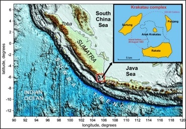
Anak Krakatau Volcano is an active volcano located in the Krakatau Complex, Sunda Strait, Indonesia. On 22 December 2018, the volcano experienced a major eruption that led to a tsunami that devastated the shores of the islands of Java and Sumatra and killed up to 437 people. The eruption also destroyed the volcano’s body and change its shape drastically and forming a large crater in the southwestern part. After that eruption, the volcano continues to grow up. This research aims to analyze the deformation of the Anak Krakatau Volcano post-2018 eruption by using the differential interferometry SAR method (DInSAR). In order to support the analysis, we additionally compare the DInSAR result with tectonic-volcanic activity. Sentinel 1-A type SLC satellite imagery data from 5 June 2019 to 7 January 2020; consisting of 19 images or 18 pairs as master and slave were used to producing a deformation map. DInSAR result shows the volcano was generally experiencing deflation during the period, ranging from -1.03 to -4.81 cm (-3.01 cm average). However, inflation also occurred ranging from 0 to 5.99 cm, correlating with shallow and deep volcanic activity and followed by eruptions in October 2019 when the highest activities were observed. Furthermore, coherence value should be highly considered along with DInSAR processing, and this research allows that coherence to be acceptable.
Downloads
References
Abdurrachman, M., Widiyantoro, S., Priadi, B., Ismail, T., 2018. Geochemistry and Structure of Krakatoa Volcano in the Sunda Strait, Indonesia. Geosciences 8, 111.
Agustan, Kimata, F., Pamitro, Y.E., Abidin, H.Z., 2012. Understanding the 2007–2008 eruption of Anak Krakatau Volcano by combining remote sensing technique and seismic data. International Journal of Applied Earth Observation and Geoinformation 14, 73–82.
Antonielli, B., Monserrat, O., Bonini, M., Righini, G., Sani, F., Luzi, G., Feyzullayev, A.A., Aliyev, C.S., 2014. Pre-eruptive ground deformation of Azerbaijan mud volcanoes detected through satellite radar interferometry (DInSAR). Tectonophysics 637, 163–177.
Astort, A., Boixart, G., Folguera, A., Battaglia, M., 2022. Volcanic unrest at Nevados de Chillán (Southern Andean Volcanic Zone) from January 2019 to November 2020, imaged by DInSAR. Journal of Volcanology and Geothermal Research 427, 107568.
Babu, A., Kumar, S., 2019. InSAR Coherence and Backscatter Images Based Analysis for the Anak Krakatau Volcano Eruption. Proceedings 24, 21.
Castañeda, C., Pourthie´, N., Souyris, J.-C., 2011. Dedicated SAR interferometric analysis to detect subtle deformation in evaporite areas around Zaragoza, NE Spain. International Journal of Remote Sensing 32, 1861–1884.
De Novellis, V., Castaldo, R., De Luca, C., Pepe, S., Zinno, I., Casu, F., Lanari, R., Solaro, G., 2017. Source modelling of the 2015 Wolf volcano (Galápagos) eruption inferred from Sentinel 1-A DInSAR deformation maps and pre-eruptive ENVISAT time series. Journal of Volcanology and Geothermal Research, Volcano Geodesy: Recent developments and future challenges 344, 246–256.
Euillades, P.A., Euillades, L.D., Blanco, M.H., Velez, M.L., Grosse, P., Sosa, G.J., 2017. Co-eruptive subsidence and post-eruptive uplift associated with the 2011–2012 eruption of Puyehue-Cordón Caulle, Chile, revealed by DInSAR. Journal of Volcanology and Geothermal Research, Volcano Geodesy: Recent developments and future challenges 344, 257–269.
Fiantis, D., Ginting, F.I., Seprianto, Halfero, F., Saputra, A.P., Nelson, M., Van Ranst, E., Minasny, B., 2021. Geochemical and mineralogical composition of the 2018 volcanic deposits of Mt. Anak Krakatau. Geoderma Regional 25, e00393.
Grilli, S.T., Tappin, D.R., Carey, S., Watt, S.F.L., Ward, S.N., Grilli, A.R., Engwell, S.L., Zhang, C., Kirby, J.T., Schambach, L., Muin, M., 2019. Modelling of the tsunami from the December 22, 2018 lateral collapse of Anak Krakatau volcano in the Sunda Straits, Indonesia. Scientific Reports 9, 11946.
Harjono, H., Diament, M., Nouaili, L., Dubois, J., 1989. Detection of magma bodies beneath Krakatau volcano (Indonesia) from anomalous shear waves. Journal of Volcanology and Geothermal Research 39, 335–348.
Heidarzadeh, M., Ishibe, T., Sandanbata, O., Muhari, A., Wijanarto, A.B., 2020. Numerical modeling of the subaerial landslide source of the 22 December 2018 Anak Krakatoa volcanic tsunami, Indonesia. Ocean Engineering 195, 106733.
Hooper, A., Zebker, H., Segall, P., Kampes, B., 2004. A new method for measuring deformation on volcanoes and other natural terrains using InSAR persistent scatterers. Geophysical Research Letters 31.
Iqbal, M., Juliarka, B.R., 2020. Identification of Permeability Level by using Fault Fracture Density Analysis and Landsat 8 OLI at Ulubelu Geothermal Area. IOP Conf. Ser.: Earth Environ. Sci. 537, 012016.
Iqbal, M., Juliarka, B.R., 2019. Analisis Kerapatan Kelurusan (Lineament Density) di Lapangan Panasbumi Suoh-Sekincau, Lampung. Journal of Science and Applicative Technology 3, 61–67.
Jaxybulatov, K., Koulakov, I., Seht, M.I., Klinge, K., Reichert, C., Dahren, B., Troll, V.R., 2011. Evidence for high fluid/melt content beneath Krakatau volcano (Indonesia) from local earthquake tomography. Journal of Volcanology and Geothermal Research 206, 96–105.
Kurniawan, R., Anjasmara, I.M., 2016. Pemanfaatan Metode Differential Intermerometry Synthetic Aperture Radar (DInSAR) untuk Pemantauan Deformasi Akibat Aktivitas Eksploitasi Panasbumi. Jurnal Teknik ITS 5, B331–B336.
Perttu, A., Caudron, C., Assink, J.D., Metz, D., Tailpied, D., Perttu, B., Hibert, C., Nurfiani, D., Pilger, C., Muzli, M., Fee, D., Andersen, O.L., Taisne, B., 2020. Reconstruction of the 2018 tsunamigenic flank collapse and eruptive activity at Anak Krakatau based on eyewitness reports, seismo-acoustic and satellite observations. Earth and Planetary Science Letters 541, 116268.
Putri, D.R., Sukmono, A., Sudarsono, B., 2018. ANALISIS KOMBINASI CITRA SENTINEL-1A DAN CITRA SENTINEL-2A UNTUK KLASIFIKASI TUTUPAN LAHAN (STUDI KASUS: KABUPATEN DEMAK, JAWA TENGAH). Jurnal Geodesi UNDIP 7, 85–96.
Self, S., 1992. Krakatau revisited: The course of events and interpretation of the 1883 eruption. GeoJournal 28, 109–121.
Sreejith, K.M., Agrawal, R., Agram, P., Rajawat, A.S., 2020. Surface deformation of the Barren Island volcano, Andaman Sea (2007–2017) constrained by InSAR measurements: Evidence for shallow magma reservoir and lava field subsidence. Journal of Volcanology and Geothermal Research 407, 107107.
Williams, R., Rowley, P., Garthwaite, M.C., 2019. Reconstructing the Anak Krakatau flank collapse that caused the December 2018 Indonesian tsunami. Geology 47, 973–976.
Downloads
Published
Issue
Section
License
Copyright @2019. This is an open-access article distributed under the terms of the Creative Commons Attribution-ShareAlike 4.0 International License which permits unrestricted use, distribution, and reproduction in any medium. Copyrights of all materials published in JGEET are freely available without charge to users or / institution. Users are allowed to read, download, copy, distribute, search, or link to full-text articles in this journal without asking by giving appropriate credit, provide a link to the license, and indicate if changes were made. All of the remix, transform, or build upon the material must distribute the contributions under the same license as the original.


