
Lineament Density and Implications for the Distribution of Ground Fissures After 2021 MW 7.3 Flores Sea Earthquake on Kalaotoa Island, Indonesia
DOI:
https://doi.org/10.25299/jgeet.2023.8.1.10849Keywords:
2021 Earthquake, Lineaments Density, Ground Fissures, Approximately Crack, DisplacementAbstract
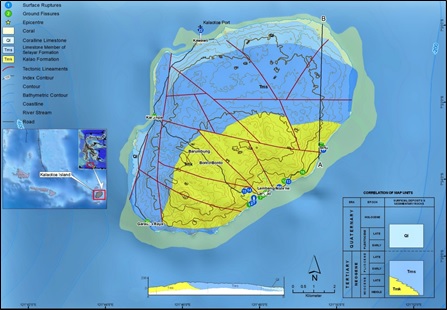
A 7.3 MW earthquake occurred at 11:20 am on December 14, 2021, in the Flores Sea, and the main shake was centered ±100 km north of Maumere, Indonesia, with a depth of 14.3 km, antecedent a landslide. This research consists of two stages, namely: quantitative data collection in the form of tectonic lineament density measurements using Shuttle Radar Topography Mission (SRTM) data which is extracted manually using GIS-based applications, and qualitative data in the form of field observations which include strike-dip measurements of rocks, lithological data, morphological conditions, ground fissures, and the distribution of damage caused after 2021 earthquake. This study focused on analyzing the value of lineament density, its correlation to the history of seismicity and surface lithological conditions, and the impact after the 2021 earthquake damage. The lineaments of the southern area are dominated by NE – SW orientation along with various lithological conditions and with lineament density values very low – very high. A crack width from 0.5 to 112 cm, and a vertical offset occurs with a depth of up to 270 cm. The western area is dominated by lineament with an orientation NE – SW with a crack width from 8 to 18 cm, and there is a vertical offset with a depth of up to 24 cm. The distribution of ground fissures in the Garaupa Raya area is categorized as low. The orientation of the northern area lineament is relatively NW – SE directional and the lineament density value is categorized as low. Horizontal displacement with an orientation of NW – SE is found at the port of Kalaotoa Island, Kawawo village with measured crack width of ±17 cm, an observable horizontal offset from 15 to 24 cm, and a vertical offset of ±12 cm with a trend of movement towards the south.
Downloads
References
Arifin, S. S., Mulyatno, B. S., Marjiyono, & Setianegara, R. (2014). Penentuan Zona Rawan Guncangan Bencana Gempa Bumi Berdasarkan Analisis Nilai Amplifikasi HVSR Mikrotremor dan Analisis Periode Dominan Daerah Liwa dan Sekitarnya. Jurnal Geofisika Eksplorasi, 2(1).
Batson, R. M., Edwards, K., & Eliason, E. M. (1975). Computer-generated shaded-relief images. Journal of Research US Geology Survey, 3(4), 401–408.
Bety, A. K. S., Al-Jawadi, A. S., & Ismaeel, O. A. (2022). Lineament Analysis by Using Remote Sensing and GIS Technique of Sangaw Area, Kurdistan Region, NE Iraq. Iraqi Geological Journal, 55(2), 150–161.
BMKG (2021). Ulasan Guncangan Tanah Akibat Gempa Bumi di Laut Flores Nusa Tenggara Timur 14 Desember 2021
Goes, S., Ruff, L., & Winslow, N. (1997). The Complex Rupture Process of the 1996 Deep Flores, Indonesia Earthquake (Mw 7.9) from teleseismic P-waves. Geophysical Research Letters, 24(11), 1295–1298.
Hall, R., & Sevastjanova, I. (2012). Australian crust in Indonesia. Australian Journal of Earth Sciences, 59(6), 827–844.
Han, L., Liu, Z., Ning, Y., & Zhao, Z. (2018). Extraction and analysis of geological lineaments combining a DEM and remote sensing images from the northern Baoji loess area. Advances in Space Research, 62(9), 2480–2493.
Hutchings, S. J., & Mooney, W. D. (2021). The Seismicity of Indonesia and Tectonic Implications.
Iqbal, M., & Juliarka, B. R. (2019). Analisis Kerapatan Kelurusan (Lineament Density) di Lapangan Panasbumi Suoh-Sekincau, Lampung. Journal of Science and Applicative Technology, 3(2), 61.
Kadarusman, A., Miyashita, S., Maruyama, S., Parkinson, C. D., & Ishikawa, A. (2004). Petrology, geochemistry and paleogeographic reconstruction of the East Sulawesi Ophiolite, Indonesia. Tectonophysics, 392(1–4), 55–83.
Koswara, A., Panggabean, H., Baharuddin, & Sukarna, D. (1994). Geological map of the Bonerate Sheet, South Sulawesi, Scale 1:250 000 (Quadrangles 2018-2019-2208). Geological Research and Development Centre.
Maulana, A., Christy, A. G., & Ellis, D. J. (2015). Petrology, geochemistry and tectonic significance of serpentinized ultramafic rocks from the South Arm of Sulawesi, Indonesia. Chemie Der Erde, 75(1), 73–87.
Maulana, A., Christy, A. G., Ellis, D. J., Imai, A., & Watanabe, K. (2013). Geochemistry of eclogite- and blueschist-facies rocks from the bantimala complex, south sulawesi, indonesia: Protolith origin and tectonic setting. Island Arc, 22(4), 427–452.
Nakamura, Y. (2000). Clear identification of fundamental idea of Nakamura’s technique and its applications. Proceedings of the 12th World Conference on Earthquake Engineering, Auckland, New Zealand 2656, 1-8.
Supendi, P., Nugraha, A. D., Widiyantoro, S., Abdullah, C. I., Rawlinson, N., Cummins, P. R., Harris, C. W., Roosmawati, N., & Miller, M. S. (2020). Fate of Forearc Lithosphere at Arc-Continent Collision Zones: Evidence From Local Earthquake Tomography of the Sunda-Banda Arc Transition, Indonesia. Geophysical Research Letters, 47(6), 1-9.
Supendi, P., Rawlinson, N., Prayitno, B. S., Widiyantoro, S., Simanjuntak, A., Palgunadi, K. H., Kurniawan, A., Marliyani, G. I., Nugraha, A. D., Daryono, D., Anugrah, S. D., Fatchurochman, I., Gunawan, M. T., Sadly, M., Adi, S. P., Karnawati, D., & Arimuko, A. (2022). The Kalaotoa Fault: A Newly Identified Fault that Generated the Mw 7.3 Flores Sea Earthquake. The Seismic Record, 2(3), 176–185.
USGS (2021). Earthhquakes.
Verdiansyah, O., & Hartono, H. G. (2017). Aplikasi Lineament Density Analysis Untuk Membatasi Pola Kaldera Purba Godean. Jurnal Teknologi Technoscientia 9(2), 162–171.
Yang, X., Singh, S. C., & Tripathi, A. (2020). Did the Flores backarc thrust rupture offshore during the 2018
Lombok earthquake sequence in Indonesia. Geophysical Journal International, 221, 758–768.
Zhumabek, Z., Assylkhan, B., Alexandr, F., Dinara, T., & Altynay, K. (2017). Automated lineament analysis to assess the geodynamic activity areas. Procedia Computer Science, 121, 699–706.
Downloads
Published
Issue
Section
License
Copyright @2019. This is an open-access article distributed under the terms of the Creative Commons Attribution-ShareAlike 4.0 International License which permits unrestricted use, distribution, and reproduction in any medium. Copyrights of all materials published in JGEET are freely available without charge to users or / institution. Users are allowed to read, download, copy, distribute, search, or link to full-text articles in this journal without asking by giving appropriate credit, provide a link to the license, and indicate if changes were made. All of the remix, transform, or build upon the material must distribute the contributions under the same license as the original.


