An Integrated GIS-Based Framework for Tsunami Evacuation Planning: Shelter Accessibility and Route Network Analysis in Palabuhanratu, Indonesia
Keywords:
Evacuation Routes, hazard mapping, Palabuhanratu, shelter planning, tsunamiAbstract
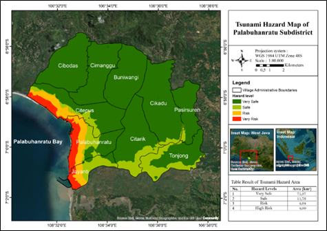
Palabuhanratu is located along the southern coast of Java and is at high risk of tsunami disasters owing to seismic gaps along the Sunda subduction zone. The seismic gap could generate earthquakes up to 9.1 Mw, potentially triggering tsunamis as high as 20.2 meters. Mitigation efforts require evacuation sites that can be reached within a limited evacuation time, yet existing temporary evacuation sites are moderately to poorly accessible, with a substantial proportion of the affected population unable to reach them within 30 minutes. This study develops an integrated GIS-based framework linking tsunami hazard mapping and inundation modeling with affected-population assessment, shelter location planning, and evacuation route analysis. The methodological approach uses existing evacuation sites as a baseline and progressively evaluates alternative shelter configurations based on population coverage within a 30-minute travel-time constraint, followed by network-based evacuation route analysis for the selected shelter configuration. GIS-based spatial analysis estimated inundation areas of 3.57 km² and 6.44 km² under 10- and 20-meter tsunami scenarios, affecting 13,553 and 23,574 people, respectively. Existing evacuation sites were reachable by only 38% of the affected population under the 20-meter inundation scenario. The addition of three proposed shelter locations increased the modeled accessibility to 100% within the 30-minute travel-time threshold. Network analysis subsequently identified 55 evacuation routes connecting tsunami-affected areas to designated evacuation sites. The integrated framework provides a systematic basis for comparing shelter configurations and linking shelter planning with evacuation route development, thereby supporting comprehensive tsunami mitigation planning in vulnerable coastal communities.
Downloads
References
Adi, A.W., Shalih, O., Shabrina, F.Z., Rizqi, A., Putra, A.S., Karimah, R., Eveline, F., Alfian, A., Syauqi, Septian, R.T., et al. (2023). IRBI (Indeks Risiko Bencana Indonesia). Volume ke-01. Jakarta: Badan Nasional Penanggulangan Bencana.
Adventari, T., Pranowo, W., Adrianto, D., Ramdhan, M., Setiyadi, J. (2021). Penjalaran tsunami menuju outlet arlindo berdasarkan skenario gempa megathrust Selatan Jawa. Jurnal Chart Datum, 07(01), 1–10.
Arifal, R., Ashar, F. (2021). Perencanaan tempat evakuasi sementara untuk bencana tsunami di kelurahan pasir nan tigo kota padang. CIVED, 8(3), 111.
Ashar, F., Amaratunga, D., Haigh. R (2014). The analysis of tsunami vertical shelter in Padang City. Procedia Econ Finance. 18 March 2016:916–923.
Benazir, B., Syamsidik, S., Idris, Y., Putra, N. (2023). Connecting community’s perspectives on tsunami risk to anticipated future tsunamis: a reflection from a progress of tsunami preparedness from a coastal community in Aceh-Indonesia after 19 years of the 2004 Indian Ocean Tsunami. Geoenvironmental Disasters. 10(21), 1-18.
Berryman, K. (2006). Review of Tsunami Hazard and Risk in New Zealand. Lower Hutt: Institute of Geological and Nuclear Sciences.
BNPB. (2012). Masterplan pengurangan risiko bencana tsunami. Jakarta: Badan Nasional Penanggulangan Bencana.
BNPB. (2013). Pedoman Teknik Perencanaan Tempat Evakuasi Sementara (TES) Tsunami. Jakarta: Badan Nasional Penanggulangan Bencana.
BNPB. (2014). Pedoman penyusunan peta risiko tsunami tingkat kabupaten/kota. Jakarta: Badan Nasional Penanggulangan Bencana.
Budiarto, I.F. (2019). Sistem informasi geografis sebaran pondok pesantren di Kota Malang. Jurnal Mhs Tek Inform. 3(1), 129–135.
Dirhamsyah, D., Umam, S., Arifin, Z. (2022). Maritime law enforcement: Indonesia’s experience against illegal fishing. Ocean Coast Manag. 229:106304.
Fauzi, R.A., Dewi, E.O., Rizara, A., Ridwana, R., Yani, A. (2022). Perbandingan Arcgis Dengan Google My Maps dalam Membantu Pembelajaran Sistem Informasi Geografis. J Pendidik Geogr Undiksha. 10(2), 186–196.
FEMA. (2019). Guidelines for Design of Structures for Vertical Evacuation From Tsunamis 3rd Edition. JettyEcnPurdueEdu. August:176.
Habibie, M.F. (2022). Analisis lokasi shelter evakuasi. IPB University.
Harris, R., Major, J. (2016). Waves of destruction in the East Indies: The Wichmann catalogue of earthquakes and tsunami in the Indonesian region from 1538 to 1877. Geol Soc London, Spec Publ. 441.
Horspool, N., Pranantyo, I.R., Griffin, J., Latief, H., Natawidjaja, D., Kongko, W., Cipta, A., Bustamam, A., Thio, H.K. 2013. Kajian Nasional Bahaya Tsunami untuk Indonesia. Geosci Aust Inst Teknol Bandung, Aust Facil Disaster Reduction, LIPI, BPDP-BPPT, Badan Geol Tsunami Disaster Mitig Res Centre, Univ Syiah Kuala, BMKG, URS Corp.,.
Isya, H.R.M., Wibowo, W.A., Arrasyid, R. (2021). Analysis of the Tsunami Disaster Risk Study in the Pelabuhanratu Bay Tourism Area. J Pendidik Ilmu Sos. 30(2), 147–156.
Kozin, M. (2016). Studi Deskriptif Koordinasi Penanggulangan Bencana Erupsi Gunung Kelud Tahun 2014 Di Kabupaten Kediri. Kebijak dan Manaj Publik. 4(1), 1–10.
Mas, E., Paulik, R., Pakoksung, K., Adriano, B., Moya, L., Suppasri, A., Muhari, A., Khomarudin, R., Yokoya, N., Matsuoka, M, et al. (2020). Characteristics of tsunami fragility functions developed using different sources of damage data from the 2018 Sulawesi earthquake and tsunami. Pure Appl Geophys. 177(6), 2437–2455.
Pradjoko, E., Karisma, A.M., Pracoyo, A., Harianto, B., Suroso, A., Saadi, Y. (2023). The Application of Two Tsunami Inundation Model in the Kuta Mandalika Coast. Proceedings of the First Mandalika International Multi-Conference on Science and Engineering 2022, MIMSE 2022 (Civil and Architecture). Atlantis Press International BV.
Pramana, B.S. 2015. Pemetaan Kerawanan Tsunami Di Kecamatan Pelabuhanratu Kabupaten Sukabumi. Soc Sci Educ J. 2(1), 76–91.
Septiangga, B., Yudistira, Y. (2019). Tsunami Inundation Modeling and Its Impact On Coastal Area of Manado City and Surrounding. In Conference: HATHI 6th International Seminar. Kupang, Indonesia.
Stefanus, A., Hutapea, A.T.J., Ibrahim, W. (2022). Penentuan jalur evakuasi dan shelter untuk kawasan pariwisata: lokasi studi Kecamatan Anyar. J Pelita Kota. 3(2), 279–297.
Suri, A.S., Syafiudin, F.M. (2024). Analisis dampak bencana tsunami dan perencanaan jalur evakuasi (studi kasus: Kabupaten Sukabumi). J Tek Sipil Dan Lingkung. 9(1), 11–20.
Tanioka, Y., Latief, H., Sunendar, H. (2012). Tsunami hazard mitigation at Palabuhanratu, Indonesia. Journal of Disaster Research. 7(1), 19-25.
Triyono, R., Prasetya, T., Anugrah, S.D., Sudrajat, A., Setiyono, U., Gunawan, I., Priyobudi., Yatimantoro, T., Hidayanti., Anggraini. S., et al. (2019). Katalog tsunami indonesia per-wilayah tahun 416-2018. Ed ke-2. Jakarta: Badan Meteorologi Klimatologi dan Geofisika.
Widiyantoro, S., Gunawan, E., Muhari, A., Rawlinson, N., Mori, J., Hanifa, N.R., Susilo, S., Supendi, P., Shiddiqi, H.A., Nugraha, A.D., et al. (2020). Implications for megathrust earthquakes and tsunamis from seismic gaps south of Java Indonesia. Sci Rep. 10(1), 1–12.
van Zuidam RA, van Zuidam-Cancelado FI. 1979. Terrain Analysis and Classification Using Aerial Photographs: A Geomorphological Approach. ITC textbook of photo-interpretation. Enschede: International Institute for Aerial Survey and Earth Sciences.
Downloads
Published
Issue
Section
License
Copyright (c) 2026 Journal of Geoscience, Engineering, Environment, and Technology

This work is licensed under a Creative Commons Attribution-ShareAlike 4.0 International License.
Copyright @2019. This is an open-access article distributed under the terms of the Creative Commons Attribution-ShareAlike 4.0 International License which permits unrestricted use, distribution, and reproduction in any medium. Copyrights of all materials published in JGEET are freely available without charge to users or / institution. Users are allowed to read, download, copy, distribute, search, or link to full-text articles in this journal without asking by giving appropriate credit, provide a link to the license, and indicate if changes were made. All of the remix, transform, or build upon the material must distribute the contributions under the same license as the original.