Optimization of Coastline Extraction Using MNDWI Thresholds and Machine Learning on Landsat Images of Wetlands in Northern East Java, Indonesia
DOI:
https://doi.org/10.25299/jgeet.2026.11.3.28479Keywords:
Shoreline, Water Index, Machine learning, Random Forest, Classification and Regression Tree, WetlandAbstract
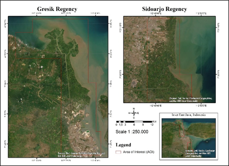
This study evaluates and compares methods for extracting coastlines in the wetland coastal areas of northern East Java, specifically in Sidoarjo and Gresik Regencies, East Java, Indonesia. By analyzing eight scenarios that integrate bands from Landsat 8 imagery, the Modified Normalized Difference Water Index (MNDWI), and the SRTM Digital Elevation Model (DEM) under two machine learning classifiers (Random Forest and Classification and Regression Trees) on the Google Earth Engine (GEE) platform. Using a dataset consisting of 180 ground-truth points, we found that Random Forest (RF) combined with MNDWI and DEM (Scenario 5) achieved the highest overall accuracy (OA = 76%, Kappa = 0.71) in the flat wetlands of Sidoarjo, which are dominated by aquaculture ponds and mangrove vegetation. In contrast to the diverse Gresik coastal area, where some regions are dominated by industry, the pure CART model (Scenario 6) yielded the best results (OA = 66%, Kappa = 0.60), as the addition of DEM and MNDWI caused overfitting due to extreme local spectral and vertical disturbances from the complex coastal structure. These results indicate that ensemble-based classification (RF) with elevation filtering is crucial for distinguishing the microtopography of aquaculture ponds from natural seawater, whereas a single decision tree (CART) performs better with raw spectral inputs in structurally heterogeneous coastal environments.
Downloads
References
Adeli, A., Dastgheib, A., Roelvink, D., 2025. Shoreline dynamics prediction using machine learning models: from process learning to probabilistic forecasting. Front. Mar. Sci. 12.
Amukti, R., Adji, A.S., Ruslan, S., 2020. Analysis of Shoreline Shift using Satellite Imagery near Makassar City. Journal of Geoscience, Engineering, Environment, and Technology 5, 133–138.
Arifianto, I., Wibowo, R.C., 2020. Analysis of the Surface Subsidence of Porong and Surrounding Area, East Java, Indonesia based on Interferometric Satellite Aperture Radar (InSAR) Data. Journal of Geoscience, Engineering, Environment, and Technology 5, 199–205.
Arjasakusuma, S., Kusuma, S.S., Saringatin, S., Wicaksono, P., Mutaqin, B.W., Rafif, R., 2021. Shoreline dynamics in East Java Province, Indonesia, from 2000 to 2019 using multi-sensor remote sensing data. Land (Basel). 10, 1–17.
Aslam, R.W., Shu, H., Naz, I., Quddoos, A., Yaseen, A., Gulshad, K., Alarifi, S.S., 2024. Machine Learning-Based Wetland Vulnerability Assessment in the Sindh Province Ramsar Site Using Remote Sensing Data. Remote Sens. (Basel). 16.
Barbier, E.B., Hacker, S.D., Kennedy, C., Koch, E.W., Stier, A.C., Silliman, B.R., 2011. The value of estuarine and coastal ecosystem services. Ecol. Monogr.
Bayram, B., Erdem, F., Akpinar, B., Ince, A.K., Bozkurt, S., Catal Reis, H., Seker, D.Z., 2017. THE EFFICIENCY OF RANDOM FOREST METHOD FOR SHORELINE EXTRACTION FROM LANDSAT-8 AND GOKTURK-2 IMAGERIES. ISPRS Annals of the Photogrammetry, Remote Sensing and Spatial Information Sciences IV-4/W4, 141–145.
Belgiu, M., Drăguţ, L., 2016. Random forest in remote sensing: A review of applications and future directions. ISPRS Journal of Photogrammetry and Remote Sensing 114, 24–31.
Çelik, O.İ., Gazioğlu, C., 2022. Coast type based accuracy assessment for coastline extraction from satellite image with machine learning classifiers. The Egyptian Journal of Remote Sensing and Space Science 25, 289–299.
Congalton, R.G., Green, K., 2008. Assessing the Accuracy of Remotely Sensed Data. CRC Press.
Costa Santos, C.S. da, Dias, F.F., Franz, B., Alves dos Santos, P.R., Fonseca Rodrigues, T. Da, Vargas, R., Américo dos Santos, C., 2019. RELATIVE SEA LEVEL RISE EFFECTS AT THE MARAMBAIA BARRIER ISLAND AND GUARATIBA MANGROVE: SEPETIBA BAY (SE BRAZIL). Journal of Sedimentary Environments 4, 249–262.
Eteh, D.R., Paaru, M., Egobueze, F.E., Okpobiri, O., 2024. Utilizing Machine Learning and DSAS to Analyze Historical Trends and Forecast Future Shoreline Changes Along the River Niger, Niger Delta. Water Conservation Science and Engineering 9.
Faiez, Z., Fan, D., 2023. Study of Coastal Morphological Changes by Tsunamis in Aceh (Indonesia) Using Satellite Images. Journal of Geoscience, Engineering, Environment, and Technology 8, 295–304.
Farda, N.M., 2017. Multi-temporal Land Use Mapping of Coastal Wetlands Area using Machine Learning in Google Earth Engine, in: IOP Conference Series: Earth and Environmental Science. Institute of Physics Publishing.
Halim, 2016. Studying the changes of coastal line by applying remote sensing approach along the coastal Areas of Soropia Subdistrict 1, 24.
Hariyanto, T., Mukhtar, M.K., Pribadi, C.B., 2018. Evaluasi Perubahan Garis Pantai Akibat Abrasi Dengan Citra Satelit Multitemporal (Studi Kasus: Pesisir Kabupaten Gianyar, Bali). Geoid 14, 66.
Khurram, S., Pour, A.B., Bagheri, M., Helmy Ariffin, E., Akhir, M.F., Bahri Hamzah, S., 2025. Satellite-Based Multi-Decadal Shoreline Change Detection by Integrating Deep Learning with DSAS: Eastern and Southern Coastal Regions of Peninsular Malaysia. Remote Sens. (Basel). 17, 3334.
Liang, Y., Zhang, J., Sun, W., Guo, Z., Li, S., 2025. Tracking the Construction Land Expansion and Its Dynamics of Ho Chi Minh City Metropolitan Area in Vietnam. Land (Basel). 14.
Li, K., Zhang, L., Chen, B., Zuo, J., Yang, F., Li, L., 2023. Analysis of China’s Coastline Changes during 1990–2020. Remote Sens. (Basel). 15, 981.
Lou, L., Chen, C., Li, M., Liu, K., 2024. Comparative Analysis of Water Body Extraction Accuracy Based on Thresholding Method. The International Archives of the Photogrammetry, Remote Sensing and Spatial Information Sciences XLVIII-4–2024, 331–336.
Marfai, M.A., Cahyadi, A., Anggraini, D.F., 2013. Typology, Dynamics, and Potential Disaster in The Coastal Area District Karst Gunungkidul. Forum Geografi 27, 147.
Mentaschi, L., Vousdoukas, M.I., Pekel, J.F., Voukouvalas, E., Feyen, L., 2018. Global long-term observations of coastal erosion and accretion. Sci. Rep. 8.
Muhammad Usman Zakaria, Wirastuti Widyatmanti, Retnadi Heru Jatmiko, 2025. Applied One-Dimensional Convolutional Neural Network Image Fusion Sentinel-1 SAR and Sentinel-2 for Classification and Mapping Dynamics of Coastal Wetlands in Segara Anakan, Cilacap Regency, Indonesia. Journal of Geoscience, Engineering, Environment, and Technology 10, 510–519.
Murray, N.J., Worthington, T.A., Bunting, P., Duce, S., Hagger, V., Lovelock, C.E., Lucas, R., Saunders, M.I., Sheaves, M., Spalding, M., Waltham, N.J., Lyons, M.B., 2022. High-resolution mapping of losses and gains of Earth’s tidal wetlands. Science (1979). 376, 744–749.
Ondara, K., Dhiauddin, R., Wisha, U.J., Rahmawan, G.A., 2020. Hydrodynamics Features and Coastal Vulnerability of Sayung Sub-District, Demak, Central Java, Indonesia. Journal of Geoscience, Engineering, Environment, and Technology 5, 32–39.
Pattipawaej, O.C., Oktaviani, K., 2023. Analysis of shoreline changes in Yogyakarta coastal areas using remote sensing method, in: IOP Conference Series: Earth and Environmental Science. Institute of Physics.
Raychaudhuri, K., Kumar, M., Bhanu, S., 2017. A Comparative Study and Performance Analysis of Classification Techniques: Support Vector Machine, Neural Networks and Decision Trees. pp. 13–21.
Sadewa, A.H., Supriyadi, A.A., 2024. The use of remote sensing in monitoring shoreline change: implications for maritime area security. Remote Sensing Technology in Defense and Environment 1, 28–35.
Simarmata, N., Adlan Nadzir, Z., Nawang Sari, D., Terusan Ryacudu, J., Way Hui, D., Jatiagung, K., Selatan, L., n.d. Analisis Perubahan Garis Pantai Menggunakan Metode Sentinel-1 Dual-Polarized Water Index ANALISIS PERUBAHAN GARIS PANTAI MENGGUNAKAN METODE SENTINEL-1 DUAL-POLARIZED WATER INDEX (SDWI) BERBASIS DATA MULTITEMPORAL PADA GOOGLE EARTH ENGINE (Shoreline Change Analysis with Sentinel-1 Dual-Polarized Water Index (SDWI) Method based on Multitemporal Data using Google Earth Engine).
Syamani 2021 Comparison of Various Spectral Indices for Optimum Extraction of Tropical Wetlands Using Landsat 8 OLI, n.d.
Tyralis, H., Papacharalampous, G., Langousis, A., 2019. A Brief Review of Random Forests for Water Scientists and Practitioners and Their Recent History in Water Resources. Water (Basel). 11, 910.
Xu, H., 2006. Modification of normalised difference water index (NDWI) to enhance open water features in remotely sensed imagery. Int. J. Remote Sens. 27, 3025–3033.
Downloads
Published
Issue
Section
License
Copyright (c) 2026 Journal of Geoscience, Engineering, Environment, and Technology

This work is licensed under a Creative Commons Attribution-ShareAlike 4.0 International License.
Copyright @2019. This is an open-access article distributed under the terms of the Creative Commons Attribution-ShareAlike 4.0 International License which permits unrestricted use, distribution, and reproduction in any medium. Copyrights of all materials published in JGEET are freely available without charge to users or / institution. Users are allowed to read, download, copy, distribute, search, or link to full-text articles in this journal without asking by giving appropriate credit, provide a link to the license, and indicate if changes were made. All of the remix, transform, or build upon the material must distribute the contributions under the same license as the original.