Multitemporal Analysis of Aboveground Carbon Stock of Seagrass Meadows using Sentinel-2 in the Coastal Area of Bontang City in 2020-2024
DOI:
https://doi.org/10.25299/jgeet.2026.11.3.28311Keywords:
Sentinel-2, Seagrass Mapping, Time-series, Carbon StockAbstract
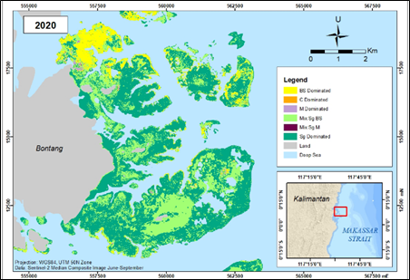
Seagrass is one of the ecosystems that absorbs large amounts of carbon in the blue carbon ecosystem. This ecosystem also has many benefits, such as becoming the habitat for fish and improving water quality. However, there is degradation of the seagrass ecosystem that requires annual carbon inventory with Sentinel-2 which covers benthic habitat areas and has high spatial resolution. This study aims to map changes in the area and distribution of seagrass meadows, as well as to map and estimate changes in aboveground carbon stocks (AGC) of seagrass meadows in part of the coast of Bontang City, East Kalimantan annually with a range of 2020-2024. The methods used in this study include integration with field data, benthic habitat classification and AGC regression with the Random Forest (RF) algorithm, accuracy testing, and multitemporal mapping to detect changes. The results of this study indicate that the benthic habitat class is dominated by seagrass which remains from 2020 to 2024 covering an area of 2643.92 hectares and the area of seagrass tends to decrease from 2808.14 hectares to 2745.94 hectares. The benthic habitat classification used to classify the seagrass area has an Overall Accuracy of 65.9%. Meanwhile, the total estimation of Seagrass AGC decreased from 287.12 tons of carbon in 2020 to 265.6 tons in 2024 of carbon from an area of 3118.6 hectares. The model from the regression results was tested for accuracy with an RMSE of 2.09 gC/m2, R2 of 0.65, and a Plot Goodness of Fit of 1:1 which explains that the estimated AGC sample is positively correlated with the field AGC sample.
Downloads
References
Ansari, R.A., Apriadi, T., Syakti, D., 2020. Carbon stock of seagrass Thalassia hemprichii and sediment in Bintan Island, Riau Archipelago. Ruaya 8, 32–37.
Arinal, V., Azhari, M., 2023. Application of linear regression for rice price prediction in Indonesia. Journal of Science and Technology 5, 341–346.
Basri, H., 2018. Multiple regression modeling for data in emotional intelligence studies. Didaktika Journal of Education 12, 103–116.
Belgiu, M., Drăgu, L., 2016. Random forest in remote sensing: A review of applications and future directions. ISPRS Journal of Photogrammetry and Remote Sensing 114, 24–31.
Bergsma, E.W.J., Almar, R., 2020. Coastal coverage of ESA’s Sentinel-2 mission. Advances in Space Research 65, 2636–2644. doi:10.1016/j.asr.2020.03.001.
BPS Kota Bontang, 2024. Bontang City in Figures 2024 (rep.).
Fauzi, A.I., Sakti, A.D., Robbani, B.F., Ristiyani, M., Agustin, R.T., Yati, E., Nuha, M.U., Anika, N., Putra, R., Siregar, D.I., Prasetyo, B.A., Julzarika, A., Wikantika, K., 2021. Assessing potential climatic and human pressures in Indonesian coastal ecosystems using a spatial data-driven approach. ISPRS International Journal of Geo-Information 10.
Fortes, M.D., Ooi, J.L.S., Tan, Y.M., Prathep, A., Bujang, J.S., Yaakub, S.M., 2018. Seagrass in Southeast Asia: A review of status and knowledge gaps, and a road map for conservation. Botanica Marina 61, 269–288.
Hedley, J.D., Harborne, A.R., Mumby, P.J., 2005. Simple and robust removal of sun glint for mapping shallow-water benthos. International Journal of Remote Sensing 26, 2107–2112.
Hidayat, R.N., Sabri, L.M., Awaluddin, M., 2019. Analysis of GNSS network design based on precision function (case study: geometric geoid points in Semarang City). Journal of Geodesy Undip 8, 48–55.
Irawan, A., Hutabarat, J., Ambariyanto, A., 2019. Threat of small-scale capture fisheries on fish biodiversity in seagrass beds. AACL Bioflux 12, 2286–2297.
Kamal, M., Kanekaputra, T., Hermayani, R., Utari, D., 2019. Effect of spatial sample distribution in modeling on the accuracy of mangrove leaf area index (LAI) estimation. Journal of Remote Sensing and Digital Image Processing 17, 101–112.
Li, H., Wan, W., Fang, Y., Zhu, S., Chen, X., Liu, B., Hong, Y., 2019. A Google Earth Engine-enabled software for efficiently generating high-quality user-ready Landsat mosaic images. Environmental Modelling & Software 112, 16–22.
Lillesand, T.M., Kiefer, R.W., Chipman, J.W., 2007. Remote sensing and image interpretation, 6th ed. John Wiley & Sons, Inc.
Lyons, M.B., Roelfsema, C.M., Phinn, S.R., 2013. Towards understanding temporal and spatial dynamics of seagrass landscapes using time-series remote sensing. Estuarine, Coastal and Shelf Science 120, 42–53.
Mukmin, Sari, L.I., Nurfadilah, 2024. Seagrass density and sediment conditions in the waters of Selangan Hamlet, Bontang City. Journal of Tropical Aquatic Science 2, 196–202.
Phan, T.N., Kuch, V., Lehnert, L.W., 2020. Land cover classification using Google Earth Engine and random forest classifier: The role of image composition. Remote Sensing 12, 2411.
Phinn, S., Roelfsema, C., Dekker, A., Brando, V., Anstee, J., 2008. Mapping seagrass species, cover and biomass in shallow waters: An assessment of satellite multi-spectral and airborne hyper-spectral imaging systems in Moreton Bay (Australia). Remote Sensing of Environment 112, 3413–3425.
Rais, M., Inaku, D.F., Moka, W.J.C., Mashoreng, S., Satari, D.Y., Rukminasari, N., 2023. Estimation of seagrass carbon stock using Spot-7 imagery in the waters of Kodingarenglompo Island, Sangkarrang, Makassar City. Journal of Tropical Marine Science 26, 387–398.
Rifai, H., Quevedo, J.M.D., Lukman, K.M., Sondak, C.F.A., Risandi, J., Hernawan, U.E., Uchiyama, Y., Ambo-Rappe, R., Kohsaka, R., 2023. Potential of seagrass habitat restorations as nature-based solutions: Practical and scientific implications in Indonesia. Ambio 52, 546–555.
Roelfsema, C., Phinn, S., 2009. A manual for conducting georeferenced photo transect surveys to assess the benthos of coral reef and seagrass habitats.
Salsabila, H.N., 2024. Multitemporal analysis of aboveground carbon stock and carbon sequestration of seagrass using PlanetScope SuperDove imagery (master’s thesis). Universitas Gadjah Mada.
Wicaksono, P., 2012. The effect of sunglint on satellite-based benthic habitat identification. International Journal of Advanced Research in Computer and Communication Engineering 1.
Wicaksono, P., Wulandari, S.A., Lazuardi, W., Munir, M., 2021a. Sentinel-2 images deliver possibilities for accurate and consistent multi-temporal benthic habitat maps in optically shallow water. Remote Sensing Applications: Society and Environment 23.
Wicaksono, P., Danoedoro, P., Hartono, Nehren, U., Maishella, A., Hafizt, M., Arjasakusuma, S., Harahap, S.D., 2021b. Analysis of field seagrass percent cover and aboveground carbon stock data for non-destructive aboveground seagrass carbon stock mapping using WorldView-2 image. ISPRS Archives of the Photogrammetry, Remote Sensing and Spatial Information Sciences 46, 321–327.
Wicaksono, P., Maishella, A., Wahyudi, A.J., Hafizt, M., 2022. Multitemporal seagrass carbon assimilation and aboveground carbon stock mapping using Sentinel-2 in Labuan Bajo 2019–2020. Remote Sensing Applications: Society and Environment 27.
Downloads
Published
Issue
Section
License
Copyright (c) 2026 Journal of Geoscience, Engineering, Environment, and Technology

This work is licensed under a Creative Commons Attribution-ShareAlike 4.0 International License.
Copyright @2019. This is an open-access article distributed under the terms of the Creative Commons Attribution-ShareAlike 4.0 International License which permits unrestricted use, distribution, and reproduction in any medium. Copyrights of all materials published in JGEET are freely available without charge to users or / institution. Users are allowed to read, download, copy, distribute, search, or link to full-text articles in this journal without asking by giving appropriate credit, provide a link to the license, and indicate if changes were made. All of the remix, transform, or build upon the material must distribute the contributions under the same license as the original.