A Review of Critical Land in Areas Dominated by Volcanic Deposits to Support Local Ecosystem Rehabilitation Planning
DOI:
https://doi.org/10.25299/jgeet.2026.11.3.27559Keywords:
Crtitical Land, Volcanic Deposit, Local Ecosystem, RehabilitationAbstract
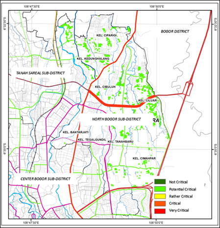
Volcanic-derived Lithosol soils dominate North Bogor District and are inherently susceptible to erosion due to their shallow profiles and limited capacity to retain water. Combined with increasing urban land-use pressures, these conditions contribute to land degradation and the development of potentially critical land. This study aims to assess the spatial distribution of potentially critical land and formulate ecosystem-based rehabilitation strategies for sustainable land management in North Bogor District. The assessment followed a GIS-based critical land evaluation framework adapted from the national guideline for critical land assessment. GIS overlay analysis was applied to integrate land cover, soil characteristics, and land management parameters, while erosion susceptibility was evaluated using the Universal Soil Loss Equation (USLE) approach. The results indicate that potentially critical land is primarily associated with volcanic-derived Lithosol soils and areas experiencing moderate to very slight erosion hazards. These areas represent priority zones for rehabilitation because their geological characteristics increase vulnerability to ongoing land degradation. Ecosystem-based rehabilitation strategies, including the establishment of locally adapted vegetation species and the implementation of contour terracing, are recommended to reduce erosion risks, improve environmental resilience, and restore land functions. This study provides an integrated framework that links geological vulnerability, erosion susceptibility, and ecosystem-based rehabilitation for prioritizing land restoration efforts, thereby supporting sustainable land management and urban environmental planning in volcanic landscapes.
Downloads
References
Alewell, C., Borrelli, P., Meusburger, K. and Panagos, P., 2019. Using the USLE: Chances, challenges and limitations of soil erosion modelling. International Soil and Water Conservation Research, 7(3), pp.203–225.
Al-Quraishi, A.M.F., 2024. Geoinformatics approaches to climate change-induced soil degradation in the MENA region: A review. In: A. Al-Quraishi, A. Negm and B. Benzougagh, eds. Climate Change and Environmental Degradation in the MENA Region. The Handbook of Environmental Chemistry, vol. 136. Cham: Springer.
Borrelli, P., Robinson, D.A., Fleischer, L.R., Lugato, E., Ballabio, C., Alewell, C., Meusburger, K., Modugno, S., Schütt, B., Ferro, V. and Bagarello, V., 2017. An assessment of the global impact of 21st century land use change on soil erosion. Nature Communications, 8(1), p.2013.
Balai Penelitian Tanah.(n.d). Soils Cartography. Bogor Puslittan
Barus B, Gandasasmita K, Tarigan S, Rusdiana O. 2011. Penyusunan kriteria lahan kritis. Kerjasama Kementerian Lingkungan Hidup dengan Pusat Pengkajian Pengembangan Wilayah (P4W) Lembaga Penelitian dan Pengabdian Kepada Masyarakat. Bogor: Institut Pertanian Bogor.
BIG. 2014. Peta Indeks Ketersediaan Data dan Informasi Geospasial Dasar skala 1:25.000, nomor_peta 1209-143
Badan Penanggulangan Bencana Kota Bogor. 2024. Infografis Kebencanaan Kota Bogor Periode 2020-2023 [Photographs].
Badan Pusat Statistik Kota Bogor. 2022. Kecamatan Tanah Sareal dalam Angka. September, 2022.
Badan Pengelola Lingkungan Hidup Daerah Kota Bogor. 2013. Inventarisasi data lahan kritis Kecamatan Bogor Timur dan Tanah Sareal Kota Bogor Tahun Anggaran 2013. Bogor: Badan Pengelola Lingkungan Hidup Daerah Kota Bogor.
Destiana, T., Umaidah, Y., dan Enri, Y. 2023. Penerapan Algoritma Gaussian Naive Bayes Dalam Penentuan Prioritas Rehabilitasi Daerah Aliran Sungai Berdasarkan Parameter Lahan Kritis. INFOTECH journal ISSN: 2460-1861 (Print), 2615-4250 (Online) Vol (9) No (2) 2023, pp. 507-513.
Dirjen RRL. 1998. Parameter Penentu Kekritisan Lahan. Departemen Kehutanan. SK Dirjen RRL No.041/Kpts/V/1998. Jakarta.
Dinas Lingkungan Hidup Daerah Kota Bogor. 2016. Inventarisasi data lahan kritis Kecamatan Tanah Sareal dan Bogor Utara Kota Bogor Tahun Anggaran 2016. Bogor: Dinas Lingkungan Hidup Daerah Kota Bogor.
Dinas Pertanian Kota Bogor.2016.Data lahan pertanian Kota Bogor. Tanggal pengambilan data Juli 2016.Dinas Pertanian Kota Bogor.
Direktorat Jenderal Planologi Kehutanan dan Tata Lingkungan. (n.d). Peta Interaktif SIGAP Kementerian LHK. Kementerian Lingkungan Hidup dan Kehutanan.
Direktur Jenderal Pengendalian Daerah Aliran Sungai dan Hutan Lindung (Dirjen PDASHL). 2018. Peraturan Direktur Jenderal Pengendalian Daerah Aliran Sungai dan Hutan Lindung Nomor P.3/PDASHL/SET/KUM.1/7/2018 Tentang petunjuk teknis penyusunan data spasial lahan kritis.
Direktur Jenderal Pengendalian Daerah Aliran Sungai dan Hutan Lindung (Dirjen PDASHL). 2017. Peraturan Direktur Jenderal Pengendalian Daerah Aliran Sungai dan Hutan Lindung Nomor P.10/PDASHL/ SET/KUM.1/8/2017 tetang Petunjuk teknis penyusunan peta daerah aliran sungai skala 1:50.000 dan peta rawan erosi.
Effendi, A.C., Kusnama, dan Hermanto, B. 1998. Peta Geologi Lembar Bogor, Jawa. Bandung. Pusat Penelitian dan Pengembangan Geologi.
Hardjowigeno, S.(1995). Ilmu tanah. Akademika pressindo. Jakarta
Keesstra, S., Mol, G., de Leeuw, J., Okx, J., de Cleen, M. and Visser, S., 2018. Soil-related sustainable development goals: Four concepts to make land degradation neutrality and restoration work. Land, 7(4), p.133.
Kementrian Lingkungan Hidup dan Kehutanan. n.d. Luas dan Penyebaran Lahan Kritis Tahun 2006, 2011, 2013, 2018 dan 2022
Li, R., Hu, W., Jia, Z., Liu, H., Zhang, C., Huang, B., Yang, S., Zhao, Y., Zhao, Y., Shukla, M.K. and Taboada, M.A., 2025. Soil degradation: A global threat to sustainable use of black soils. Pedosphere, 35(1), pp.264–279.
Pamungkas, H.S.R., Yogaswara, L.M., Adhitia, I., dan Karmadi, M.A. 2023. Review dan Pemetaan Lahan Kritis Dalam Wilayah Urban. Jurnal Teknik Vol.24. No. 02, 2023.
Pamungkas, H.S.R., Syahbandar, M.Y., dan Adhitia, I.2022. Pemetaan tanah longsor sebagai upaya mitigasi bencana sebuah kota. Jurnal Teknik Vol.23. No.1, Juni 2022.
Pamungkas, H.S.R., Adhitia, I., dan Yogaswara, L.M., 2018. Pemetaan Lahan Kritis Pada Kawasan Lindung Di Luarkawasan Hutan. Seminar Nasional Geomatika 2018 3:1099. DOI: 10.24895/SNG.2018.3-0.1014
Panagos, P., Borrelli, P., Poesen, J., Ballabio, C., Lugato, E., Meusburger, K., Montanarella, L. and Alewell, C., 2015. The new assessment of soil loss by water erosion in Europe. Environmental Science and Policy, 54, pp.438–447.
Pemerintah Kota Bogor.2021.Peraturan Daerah Kota Bogor No. 6 Tahun 2021 tentang Perubahan Atas Peraturan Daerah Nomor 8 Tahun 2011 Tentang Rencana Tata Ruang Wilayah Kota Bogor Tahun 2011-2031.
Republik Indonesia. 2020. Undang-undang (UU) Nomor 11 Tahun 2020 tentang Cipta Kerja. LN.2020/No.245, TLN No.6573, jdih.setneg.go.id : 769 hlm.
Republik Indonesia. 2019. Peraturan Presiden (Perpres) Nomor 59 Tahun 2019 tentang Pengendalian Alih Fungsi Lahan Sawah. LN.2019/NO.163, SIPUU.SETKAB.GO.ID, LL : 15 HLM.
Republik Indonesia. 2009. Kementerian Kehutanan. 2009. Peraturan Menteri Kehutanan Nomor. P.32/Menhut-II/2009 tentang Tata Cara Penyusunan Teknis Rehabilitasi Hutan dan Lahan Daerah Aliran Sungai (RTkRHL-DAS).
Republik Indonesia. 2001. Keputusan Menteri Kehutanan no. 52/Kpts-II/2001 Tentang Pedoman Penyelenggaraan Pengelolaandaerah Aliran Sungai.
Setiawati, T.C., Verdiawan, R.P., Susilowati, L.E., Basuki, Matovani, S., Hermiyanto, B. and Efendi, S., 2026. Volcanic ash deposition and its implications for soil biological fertility: Insights from the slopes of Mount Semeru, Indonesia. Jurnal Ilmiah Pertanian Indonesia, 12(5).
Wang, J., Zhen, J., Hu, W., Chen, S., Lizaga, I., Zeraatpisheh, M. and Yang, X., 2023. Remote sensing of soil degradation: Progress and perspective. International Soil and Water Conservation Research, 11(3), pp.429–454.
Wu, W., Zhang, J., Yu, J., Sun, Z., Yu, R., Liu, W. and Fang, M., 2024. Attribution analysis of soil degradation using change vector analysis and the geographical detector from 2010 to 2020 on Hainan Island. Ecological Informatics, 80, 102484.
Downloads
Published
Issue
Section
License
Copyright (c) 2026 Journal of Geoscience, Engineering, Environment, and Technology

This work is licensed under a Creative Commons Attribution-ShareAlike 4.0 International License.
Copyright @2019. This is an open-access article distributed under the terms of the Creative Commons Attribution-ShareAlike 4.0 International License which permits unrestricted use, distribution, and reproduction in any medium. Copyrights of all materials published in JGEET are freely available without charge to users or / institution. Users are allowed to read, download, copy, distribute, search, or link to full-text articles in this journal without asking by giving appropriate credit, provide a link to the license, and indicate if changes were made. All of the remix, transform, or build upon the material must distribute the contributions under the same license as the original.