Site Characterization Based on Shear-Wave Velocity Using Multichannel Analysis of Surface Waves (MASW) Method in Urban Areas of Aceh Besar, Indonesia
Keywords:
MASW, surface wave, Shear Wave Velocites, Site Characterization, Aceh BesarAbstract
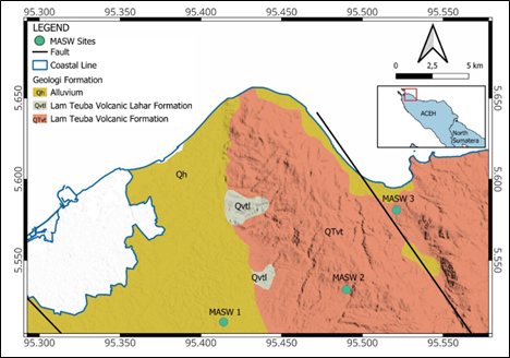
Seismic site characterization is needed for earthquake risk mitigation and also for geotechnical infrastructure design. Multichannel Analysis of Surface Waves (MASW) can be used for seismic site characterization. The method extracts shear-wave velocity (Vs) profiles from surface wave analysis that reveal geotechnical conditions and subsurface structures. This study aims to characterize the subsurface layers using the MASW method in Aceh Besar. Data acquisition was carried out along three measurement profiles, each 69 meters long and with a receiver spacing of 3 meters. Shear-wave velocities (Vs) of the subsurface soil and rock layers were estimated using dispersion curve analysis and 1D inversion. The surface wave spectral analysis produced a high-quality dispersion at the fundamental mode frequency of 20–30 Hz. The inversion process, validated by an excellent misfit curve, yields a seven-layer Vs model with RMS values mostly below 0.01. The 2D pseudo-section models based on 1D inversion results show a subsurface stratification consisting of a soft to medium overburden (Vs < 350 m/s) layer of 15 meters thick, followed by a transition zone of dense soil, and engineering bedrock (Vs > 750 m/s) found at a depth of 30 to 40 meters. In general, lateral variations were identified as undulating bedrock topography and local basin structures. Based on SNI 1726:2019, the site is classified as Medium Soil (SD) to Very Dense Soil (SC), with an estimated Vs value influenced by the thickness of the surface sediment. These results provide a valuable overview of subsurface conditions from site characterization and can serve as a basis for geotechnical planning in the study area.
Downloads
References
Aki, K., 1993. Local site effects on weak and strong ground motion. Tectonophysics 218, 93–111.
Asnawi, Y., Simanjuntak, A., Muksin, U., Rizal, S., Syukri, M.S.M., Maisura, M., Rahmati, R., 2022. Analysis of microtremor H/V spectral ratio and public perception for disaster mitigation. Geomate Journal 23, 123–130.
Bennet, J.D., 1981. Peta Geologi Lembar Banda Aceh, Sumatera (Skala 1:250.000). Pusat Penelitian dan Pengembangan Geologi (PPPG), Bandung.BMKG, 2025. Gempa Bumi M 5,0+ - BMKG [WWW Document]. BMKG - Badan Meteorologi, Klimatologi, dan Geofisika.
Delfebriyadi, D., Irsyam, M., Hutapea, B.M., Imran, I., Asrurifak, M., 2019. Determination of The Site Amplification on Deep Soil Layer Using 1-D Site Response Analysis (Case study: Jakarta City, Indonesia). Journal of Engineering and Technological Sciences 51, 824–838.
Deodatis, G., Shinozuka, M., Papageorgiou, A., 1990. Stochastic wave representation of seismic ground motion. I: FK spectra. Journal of engineering mechanics 116, 2363–2379.
Khadrouf, I., El Hammoumi, O., El Goumi, N., Oukassou, M., 2024. Contribution of HVSR, MASW, and geotechnical investigations in seismic microzonation for safe urban extension: A case study in Ghabt Admin (Agadir), western Morocco. Journal of African Earth Sciences 210, 105138.
Khalqillah, A., Muksin, U., Musfirah, Ningsih, W.A., Irwandi, 2019. SVIM: A Program for Seismic Vulnerability Index Determination and HVSR Data Processing. IOP Conference Series.: Earth and EnvironmentalScience. 273, 012016.
Kuo, C.-H., Wen, K.-L., Lin, C.-M., Wen, S., Huang, J.-Y., 2015. Investigating Near Surface S-Wave Velocity Properties Using Ambient Noise in Southwestern Taiwan. Terrestrial, Atmospheric & Oceanic Sciences 26.
Lay, T., Kanamori, H., Ammon, C.J., Nettles, M., Ward, S.N., Aster, R.C., Beck, S.L., Bilek, S.L., Brudzinski, M.R., Butler, R., DeShon, H.R., Ekström, G., Satake, K., Sipkin, S., 2005. The Great Sumatra-Andaman Earthquake of 26 December 2004. Science 308, 1127–1133.
Ma, K., Lee, C., Tsai, Y., Shin, T., Mori, J., 1999. The Chi‐Chi, Taiwan earthquake: Large surface displacements on an inland thrust fault. Eos, Transactions American Geophysical Union 80, 605–611.
Masrurah, Z., Mufadhillah, P.A., Adianur, R., Mohammed, M.A., Amsir, A., 2024. Using Multichannel Analysis of Surface Wave to Assess Bedrock Depth in Grand Aceh Baet Residential Area. Journal 0fPhysics.: Conference Series 2916, 012020.
Nagamani, D., Sivaram, K., Rao, N.P., Satyanarayana, H.V.S., 2020. Ambient noise and earthquake HVSR modelling for site characterization in southern mainland, Gujarat. Journal of Earth System Science 129, 195.
Park, C.B., Miller, R.D., Xia, J., 1999. Multichannel analysis of surface waves. Geophysics 64, 800–808.
Sieh, K., Natawidjaja, D., 2000. Neotectonics of the Sumatran fault, Indonesia. Journal of Geophysical Research: Solid Earth 105, 28295–28326.
Socquet, A., Hollingsworth, J., Pathier, E., Bouchon, M., 2019. Evidence of supershear during the 2018 magnitude 7.5 Palu earthquake from space geodesy. Nature Geoscience 12, 192–199.
Supendi, P., Winder, T., Rawlinson, N., Bacon, C.A., Palgunadi, K.H., Simanjuntak, A., Kurniawan, A., Widiyantoro, S., Nugraha, A.D., Shiddiqi, H.A., 2023. A conjugate fault revealed by the destructive Mw 5.6 (November 21, 2022) Cianjur earthquake, West Java, Indonesia. Journal of Asian Earth Sciences 257, 105830.
Syukri, M., Darisma, D., Cahyan, F.A., Sugito, Z., 2021. Spatial and Temporal Analysis of b-value Imaging Characteristics Using High Precision Earthquake Spot in the Sumatran Subduction Zone. The Iraqi Geological Journal 1–11.
Wathelet, M., Chatelain, J., Cornou, C., Giulio, G.D., Guillier, B., Ohrnberger, M., Savvaidis, A., 2020. Geopsy: A user‐
friendly open‐source tool set for ambient vibration processing. Seismological Research Letters 91, 1878–1889.
Wibowo, N.B., Fathani, T.F., Pramumijoyo, S., Marliyani, G.I., 2024. Comparison of the vs30 model and site class based on MASW, microtremor and N-SPT data in the Opak River Basin. IOP Conference Series.: Earth and Environmental Science 1373, 012002.
Yunita, H., Setiawan, B., Saidi, T., Abdullah, N., 2018. Site response analysis for estimating seismic site amplification in the case of Banda Aceh - Indonesia. MATEC Web of Conferences. 197, 10002.
Downloads
Published
Issue
Section
License
Copyright (c) 2026 Journal of Geoscience, Engineering, Environment, and Technology

This work is licensed under a Creative Commons Attribution-ShareAlike 4.0 International License.
Copyright @2019. This is an open-access article distributed under the terms of the Creative Commons Attribution-ShareAlike 4.0 International License which permits unrestricted use, distribution, and reproduction in any medium. Copyrights of all materials published in JGEET are freely available without charge to users or / institution. Users are allowed to read, download, copy, distribute, search, or link to full-text articles in this journal without asking by giving appropriate credit, provide a link to the license, and indicate if changes were made. All of the remix, transform, or build upon the material must distribute the contributions under the same license as the original.