Analysis of Earthquake Risk Zones Using the Horizontal to Vertical Spectral Ratio (HVSR) Method at Vital Objects of Radin Inten II Airport, Natar Market, and Branti Market
DOI:
https://doi.org/10.25299/jgeet.2026.11.3.25180Keywords:
HVSR, dominant frequency, amplification, Vs30, seismic vulnerability, earthquake risk zoneAbstract
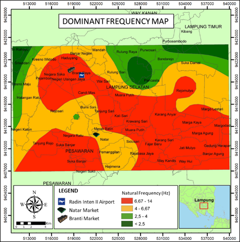
South Lampung, Indonesia, lies within the tectonically active Indo-Australian–Eurasian subduction zone, influenced by the Lampung-Panjang and Menanga Faults. Volcanic and volcaniclastic lithologies overlying thick alluvial sediments increase seismic amplification potential. This region hosts critical infrastructure including airports and markets, but seismic hazard at these sites has not been comprehensively evaluated. Therefore, this study aims to assess seismic hazard at three critical infrastructure sites: Radin Inten II Airport, Natar Market, and Branti Market. The earthquake hazard zones were analyzed using the Horizontal to Vertical Spectral Ratio (HVSR) method, which effectively estimates site resonance frequency ( ), amplification ( ), and shear-wave velocity ( ) without requiring active seismic sources or boreholes, making it ideal for rapid microzonation in urban-vital areas. Unlike previous HVSR studies in Lampung that focused on single-parameter ( ) mapping, this study integrates five parameters ( , , , , and ) to produce a multi-criteria hazard classification. Microtremor data were collected from 25 measurement sites using the Seismometer Rakyat Indonesia (SRI) and processed using Geopsy, Excel, and MATLAB. These analyses yielded dominant frequency ( ) ranging from 0.6-14 Hz, amplification factor ( ) from 0.8-5.2, dominant period ( ) from 0.07-1.6 s, seismic vulnerability index ( ) from 0.06-3.9 cm/s², and shear-wave velocity up to a depth of 30 meters ( ) from 254-1433 m/s. These parameters were then spatially integrated to assess the seismic hazard level at each study site, with and as primary classifiers and , , as corroborating indicators. The results showed that Radin Inten II Airport and Branti Market exhibit stable seismic characteristics with high dominant frequencies (>6 Hz), low amplification (<3), short dominant periods (<0.25 s), low (<1 cm/s²), and high values (>350 m/s), thus categorizing them as low-risk zones. Meanwhile, Natar Market is located within an area showing moderate dominant frequency (4-6.67 Hz) and amplification (3-6), along with a longer dominant period (0.25-0.4 s) and high values (>350 m/s), placing it in a medium-risk zone. These findings provide a scientific basis for site-specific seismic risk mitigation at critical infrastructure in South Lampung.
Downloads
References
Amirudin, A., Prasetyo, A.R., Faris, F., 2023. Seismic vulnerability analysis using the horizontal to vertical spectral ratio method on the West Palu Bay coastline. Journal of Geoscience, Engineering, Environment, and Technology, 8(02-2), 121–130.
Arifin, S.S., Mulyatno, B.S., Marjiyono, Setianegara, R., 2014. Penentuan zona rawan guncangan bencana gempa bumi berdasarkan analisis nilai amplifikasi HVSR mikrotremor dan analisis periode dominan daerah Liwa dan sekitarnya. JGE (Jurnal Geofisika Eksplorasi), 2(1), 30–40.
Arintalofa, V., Yulianto, G., Harmoko, U., 2020. Analisa mikrotremor menggunakan metode HVSR untuk mengetahui karakteristik bawah permukaan manifestasi panas bumi Diwak dan Derekan berdasarkan nilai Vp. Jurnal Energi Baru dan Terbarukan, 1(2), 54–61.
BSN, 2019. SNI 1726:2019 - Tata cara perencanaan ketahanan gempa untuk struktur bangunan gedung dan nongedung. Badan Standardisasi Nasional, Jakarta.
Bignardi, S., Yezzi, A.J., Fiussello, S., Comelli, A., 2018. OpenHVSR - Processing toolkit: enhanced HVSR processing of distributed microtremor measurements and spatial variation of their informative content. Computers & Geosciences, 120, 10–20.
Boore, D.M., Thompson, E.M., Cadet, H., 2011. Regional correlations of VS30 and velocities averaged over depths less than and greater than 30 meters. Bulletin of the Seismological Society of America, 101(6), 3046–3059.
Bonnefoy-Claudet, S., Cotton, F., Bard, P.-Y., 2006. The nature of noise wavefield and its applications for site effects studies: a literature review. Earth-Science Reviews, 79(3-4), 205–227.
Chopra, A.K., 2012. Dynamics of structures: theory and applications to earthquake engineering. 4th ed. Prentice Hall, Upper Saddle River, NJ.
Haerudin, N., Alami, F., Yogi, I.B.S., 2020. The effect site analysis based on microtremor data using the Horizontal to Vertical Spectral Ratio (HVSR) method in the Bandar Lampung City. Journal of Physics: Conference Series, 1572(1), 012075.
Haghshenas, E., Bard, P.-Y., Theodulidis, N., 2008. Empirical evaluation of microtremor H/V spectral ratio. Bulletin of Earthquake Engineering, 6(1), 75–108.
Hanifah, D.R., 2023. Penyusunan peta kerentanan gempa di Berbah Kabupaten Sleman menggunakan metode Horizontal to Vertical Spectral Ratio (HVSR) berdasarkan pengukuran mikrotremor di lapangan. Undergraduate thesis. Universitas Islam Indonesia, Yogyakarta.
Hesti, H., Mulyasari, R., Hidayatika, A., Haerudin, N., Nurlaili, J., 2024. Analisis karakteristik lapisan tanah di daerah patahan lokal berdasarkan data mikrotremor di Kabupaten Pesawaran. Journal Online of Physics, 9(3), 136–141.
Koçkar, M.K., Akgün, M., 2008. On the use of microtremor recordings in the determination of local site effects. Bulletin of Earthquake Engineering, 6(4), 447–468.
Kramer, S.L., 1996. Geotechnical earthquake engineering. Prentice Hall, Upper Saddle River, NJ.
Mangga, S.A., Amirudin, Suwarna, N., Gafoer, S., Sidarto, 2010. Geological map of the Tanjungkarang quadrangle, Sumatera. Pusat Survei Geologi, Bandung.
Meilinda, A., Suryani, I., Putra, J.A., 2023. Analisa potensi kerentanan tanah daerah Padang Cermin menggunakan metode Horizontal to Vertical Spectral Rasio. Jurnal Lingkungan dan Bencana Geologi, 14(2), 76–84.
Molnar, S., Cassidy, J.F., Castellaro, S., Cornou, C., Crow, H., Hunter, J.A., Philips, D., Roten, D., Thompson, E.M., 2022. Review of the horizontal-to-vertical spectral ratio (HVSR) method. Surveys in Geophysics, 43, 431–474.
Nakamura, Y., 1989. A method for dynamic characteristics estimation of subsurface using microtremor on the ground surface. Quarterly Report of the Railway Technical Research Institute, 30(1), 25–33.
Nakamura, Y., 2000. Clear identification of fundamental idea of Nakamura's technique and its applications. In: Proceedings of the 12th World Conference on Earthquake Engineering, Auckland, paper 2656.
Nurfitriana, I., Wibowo, A., Rudianto, R., 2021. Relokasi gempa bumi swarm di Pesawaran-Lampung, Januari 2021. Jurnal Geocelebes, 5(1), 91–101.
Prasetya, A.R., Faris, F., Rahardjo, A.P., 2024. Study of local site effects for seismic vulnerability mitigation based on microtremor measurements in the NYIA airport area. GEOMATE Journal, 26(113), 148–155.
Puhi, A.R., Widiyantoro, S., Gunawan, H., Nugraha, A.D., 2021. Crustal structure study in Lampung region using teleseismic receiver function analysis. Journal of Physics: Conference Series, 2110, 012002.
Putra, A.K., Yatini, Y., Paripurno, E.T., 2023. Application of HVSR method on microtremor data for analysis of earthquake potential in Candipuro District, Lumajang, Indonesia. Journal of Geoscience, Engineering, Environment, and Technology, 8(4), 288–294.
Rustadi, R., Rananda, E., 2020. Rock formation and site class in Bandar Lampung. JGE (Jurnal Geofisika Eksplorasi), 6(3), 183–189.
Sánchez-Sesma, F.J., Rodríguez, M., Iturrarán-Viveros, U., Luzón, F., Campillo, M., Margerin, L., García-Jerez, A., Suárez, M., Santoyo, M.A., Ordaz, M., 2011. A theory for microtremor H/V spectral ratio: application for a layered medium. Geophysical Journal International, 186(1), 221–225.
Salsabila, R.S., Fattah, E.I., Darisma, D., Hidayati, D.M., Hasanah, U., 2025. Mikrozonasi seismik menggunakan metode Horizontal to Vertical Spectral Ratio (HVSR) di Kampus ITERA, Lampung Selatan. INSOLOGI (Jurnal Sains dan Teknologi), 4(5), 1196–1202.
SESAME, 2004. Guidelines for the implementation of the H/V spectral ratio (HVSR) technique on ambient vibrations: measurements, processing and interpretation. Deliverable D23.12, European Commission, Research General Directorate, Brussels.
Siagian, S., Refrizon, Hadi, A.I., 2025. Mapping of natural frequency, amplification, seismic vulnerability, and Vs30 velocity in Selebar District, Bengkulu City. Jurnal Fisika Universitas Negeri Semarang, 15(1), 20–29.
Sieh, K., Natawidjaja, D.H., 2000. Neotectonics of the Sumatran fault, Indonesia. Journal of Geophysical Research: Solid Earth, 105(B12), 28295–28326.
Sihotang, N., Refrizon, Hadi, A.I., 2025. Resonance and damping ratio analysis of the Baiturrahman Mosque Tower based on earthquake ground shaking. Journal of Geoscience, Engineering, Environment, and Technology, 10(2), 270–274.
Statistics of Lampung Selatan Regency, 2022. Lampung Selatan Regency in figures 2022. BPS-Statistics of Lampung Selatan Regency, Kalianda.
Sulandari, S., Nurfitriana, I., Hesti, H., Rudianto, R., 2023. Deliniasi struktur Sesar Lampung-Panjang dan identifikasi kelurusan struktur bawah permukaan di Bandar Lampung dan sekitarnya menggunakan metode magnet. Jurnal Geologi dan Sumberdaya Mineral, 24(3), 145–158.
Wathelet, M., Chatelain, J.-L., Cornou, C., Di Giulio, G., Guillier, B., Ohrnberger, M., Savvaidis, A., 2020. Geopsy: a user-friendly open-source tool set for ambient vibration processing. Seismological Research Letters, 91(3), 1878–1889.
Widiyantoro, S., Gunawan, H., Nugraha, A.D., Taufiqurrahman, I., Widodo, I., 2024. Seismicity of Sumatra and western Sunda Arc and implications for back-arc thrusting. Scientific Reports, 14, 13115.
Downloads
Published
Issue
Section
License
Copyright (c) 2026 Journal of Geoscience, Engineering, Environment, and Technology

This work is licensed under a Creative Commons Attribution-ShareAlike 4.0 International License.
Copyright @2019. This is an open-access article distributed under the terms of the Creative Commons Attribution-ShareAlike 4.0 International License which permits unrestricted use, distribution, and reproduction in any medium. Copyrights of all materials published in JGEET are freely available without charge to users or / institution. Users are allowed to read, download, copy, distribute, search, or link to full-text articles in this journal without asking by giving appropriate credit, provide a link to the license, and indicate if changes were made. All of the remix, transform, or build upon the material must distribute the contributions under the same license as the original.