
Landslide Susceptibility Mapping Using Logistic Regression Methods in Bogor Regency
DOI:
https://doi.org/10.25299/jgeet.2025.10.1.1.24273Keywords:
Logistic Regression (LR), Landslide probability, Bogor Regency, Remote SensingAbstract
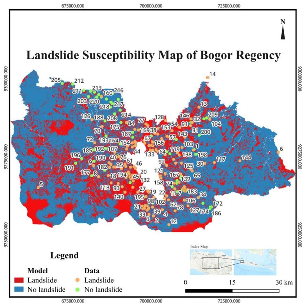
Landslides are a recurrent hazard in Bogor Regency, where steep volcanic terrain, high rainfall, varied lithology, land-use changes and active faults contribute to slope instability. This study presents the first regency-wide landslide susceptibility model using Logistic Regression supported by field validation. A dataset of 220 landslide occurrences from 2017 to 2022 and multiple geospatial factors including rainfall, slope, lithology, landcover, and NDVI was analyzed using a 70:30 train–test split to generate coefficient weights, probability surfaces and a binary susceptibility map derived from ROC-AUC thresholds. Landcover shows the strongest positive influence on landslide occurrence, whereas NDVI has the strongest negative effect, reflecting the stabilizing role of vegetation. Fault proximity exhibits near-zero influence, likely due to inactive structures or limited spatial resolution. The model achieved 82 percent accuracy with an AUC of 0.86. Susceptibility clustering near historical data suggests possible inventory bias. Improving model reliability will require more evenly distributed landslide data and UAV-based mapping to detect vegetation-covered past landslides.
Downloads
References
Achdan, A. and Sudana, D. (1992) Geological Map of Karawang Quadrangle, Java. 1st edn. [Map]. Geological Research and Development Center.
Akgun, A. (2012) ‘A comparison of landslide susceptibility maps produced by logistic regression, multi-criteria decision, and likelihood ratio methods: A case study at İzmir, Turkey’, Landslides, 9(1), pp. 93–106. doi:10.1007/s10346-011-0283-7
Bachri, S. (2014) ‘Pengaruh tektonik regional terhadap pola struktur dan tektonik Pulau Jawa’, Jurnal Geologi dan Sumberdaya Mineral, 15(4), pp. 215–221. doi:10.33332/jgsm.geologi.v15i4.60
Batar, A.K. and Watanabe, T. (2021) ‘Landslide susceptibility mapping and assessment using geospatial platforms and weights of evidence (WoE) method in the Indian Himalayan Region: Recent developments, gaps, and future directions’, ISPRS International Journal of Geo-Information, 10(3), p. 114. doi:10.3390/ijgi10030114
Bogor Recency DMA (2023) Data Bencana Kabupaten Bogor 2022. BPBD Kabupaten Bogor.
Bruce, P., Bruce, A. and Gedeck, P. (2020) Practical statistics for data scientists: 50+ essential concepts using R and Python. Sebastopol: O’Reilly Media.
Budimir, M.E.A., Atkinson, P.M. and Lewis, H.G. (2015) ‘A systematic review of landslide probability mapping using logistic regression’, Landslides, 12(3), pp. 419–436. doi:10.1007/s10346-014-0550-5
Dai, F.C. and Lee, C.F. (2002) ‘Landslide characteristics and slope instability modeling using GIS, Lantau Island, Hong Kong’, Geomorphology, 42(3–4), pp. 213–228. doi:10.1016/S0169-555X(01)00087-3
Effendi, A.C., Kusnama, H.B. and Hermanto, B. (1998) Geological Map of Bogor Quadrangle, Java. 2nd edn. [Map]. Geological Survey Center.
Feizizadeh, B. and Blaschke, T. (2013) ‘GIS-multicriteria decision analysis for landslide susceptibility mapping: Comparing three methods for the Urmia Lake Basin, Iran’, Natural Hazards, 65(3), pp. 2105–2128. doi:10.1007/s11069-012-0463-3
Felicísimo, Á.M., Cuartero, A., Remondo, J. and Quirós, E. (2013) ‘Mapping landslide susceptibility with logistic regression, multiple adaptive regression splines, classification and regression trees, and maximum entropy methods’, Landslides, 10(2), pp. 175–189. doi:10.1007/s10346-012-0320-1
Highland, L.M. and Bobrowsky, P. (2008) The landslide handbook: A guide to understanding landslides. US Geological Survey Circular 1325. doi:10.3133/cir1325
Hong, H. et al. (2018) ‘Landslide susceptibility mapping using J48 Decision Tree with AdaBoost, Bagging and Rotation Forest ensembles in the Guangchang area (China)’, CATENA, 163, pp. 399–413. doi:10.1016/j.catena.2018.01.005
Huang, F. et al. (2023) ‘Uncertainties of landslide susceptibility prediction considering different landslide types’, Journal of Rock Mechanics and Geotechnical Engineering, 15(11), pp. 2954–2972. doi:10.1016/j.jrmge.2023.03.001
Hungr, O., Leroueil, S. and Picarelli, L. (2014) ‘The Varnes classification of landslide types, an update’, Landslides, 11(2), pp. 167–194. doi:10.1007/s10346-013-0436-y
Kavzoglu, T., Sahin, E.K. and Colkesen, I. (2014) ‘Landslide susceptibility mapping using GIS-based multi-criteria decision analysis, support vector machines, and logistic regression’, Landslides, 11(3), pp. 425–439. doi:10.1007/s10346-013-0391-7
Keefer, D.K. (1984) ‘Landslides caused by earthquakes’, Geological Society of America Bulletin, 95(4), pp. 406–421. doi:10.1130/0016-7606(1984)95<406:LCBE>2.0.CO;2
Lee, S. (2005) ‘Application of logistic regression model and its validation for landslide susceptibility mapping using GIS and remote sensing data’, International Journal of Remote Sensing, 26(7), pp. 1477–1491. doi:10.1080/01431160412331331012
Lee, S. and Sambath, T. (2006) ‘Landslide susceptibility mapping in the Damrei Romel area, Cambodia using frequency ratio and logistic regression models’, Environmental Geology, 50(6), pp. 847–855. doi:10.1007/s00254-006-0256-7
Mandal, B., Mondal, S. and Mandal, S. (2023) ‘GIS-based landslide susceptibility zonation (LSZ) mapping of Darjeeling Himalaya, India using weights of evidence (WoE) model’, Arabian Journal of Geosciences, 16(7), p. 421. doi:10.1007/s12517-023-11523-w
Myronidis, D., Papageorgiou, C. and Theophanous, S. (2016) ‘Landslide susceptibility mapping based on landslide history and analytic hierarchy process (AHP)’, Natural Hazards, 81(1), pp. 245–263. doi:10.1007/s11069-015-2075-1
Pacheco Quevedo, R. et al. (2023) ‘Land use and land cover as a conditioning factor in landslide susceptibility: A literature review’, Landslides, 20(5), pp. 967–982. doi:10.1007/s10346-022-02020-4
Poedjoprajinto, S. (2011) Peta Geomorfologi Foto Pulau Jawa dan Madura. 1st edn. [Map]. Bandung: Pusat Survei Geologi.
Pourghasemi, H.R., Pradhan, B. and Gokceoglu, C. (2012) ‘Application of fuzzy logic and analytical hierarchy process (AHP) to landslide susceptibility mapping at Haraz Watershed, Iran’, Natural Hazards, 63(2), pp. 965–996. doi:10.1007/s11069-012-0217-2
Pulunggono, A.D. and Martodjojo, S. (1994) ‘Perubahan tektonik Paleogen–Neogen merupakan peristiwa tektonik terpenting di Jawa’, Proceedings of Geology and Geotechnics of Java Island, Yogyakarta, pp. 37–49.
Reichenbach, P. et al. (2018) ‘A review of statistically-based landslide susceptibility models’, Earth-Science Reviews, 180, pp. 60–91. doi:10.1016/j.earscirev.2018.03.001
Regmi, N.R., Giardino, J.R. and Vitek, J.D. (2010) ‘Assessing susceptibility to landslides: Using models to understand observed changes in slopes’, Geomorphology, 122(1), pp. 25–38. doi:10.1016/j.geomorph.2010.05.009
Saaty, T.L. (2008) ‘Decision making with the analytic hierarchy process’, International Journal of Services Sciences, 1(1), pp. 83–98. doi:10.1504/IJSSCI.2008.017590
Sassa, K., Picarelli, L. and Yueping, Y. (2009) ‘Monitoring, prediction and early warning’, in Sassa, K. and Canuti, P. (eds.) Landslides – disaster risk reduction. Berlin: Springer, pp. 351–375. doi:10.1007/978-3-540-69970-5_20
Schwarz, M. et al. (2010) ‘Quantifying the role of vegetation in slope stability: A case study in Tuscany (Italy)’, Ecological Engineering, 36(3), pp. 285–291. doi:10.1016/j.ecoleng.2009.06.014
Steger, S. et al. (2017) ‘The influence of systematically incomplete shallow landslide inventories on statistical susceptibility models and suggestions for improvements’, Landslides, 14(5), pp. 1767–1781. doi:10.1007/s10346-017-0820-0
Stokes, A. et al. (2009) ‘Desirable plant root traits for protecting natural and engineered slopes against landslides’, Plant and Soil, 324(1), pp. 1–30. doi:10.1007/s11104-009-0159-y
Sudjatmiko, S. (1972) Peta Geologi Lembar Cianjur, Jawa Barat. [Map]. Pusat Penelitian dan Pengembangan Geologi.
Sudjatmiko, S. (1992) Geological Map of Leuwidamar Quadrangle, Java. 2nd edn. [Map]. Geological Research and Development Center.
Süzen, M.L. and Doyuran, V. (2004) ‘A comparison of the GIS-based landslide susceptibility assessment methods: Multivariate versus bivariate’, Environmental Geology, 45(5), pp. 665–679. doi:10.1007/s00254-003-0917-8
Tien Bui, D. et al. (2012) ‘Landslide susceptibility mapping at Hoa Binh Province (Vietnam) using an adaptive neuro-fuzzy inference system and GIS’, Computers & Geosciences, 45, pp. 199–211. doi:10.1016/j.cageo.2011.10.031
Turkandi, T. et al. (1992) Geological Map of Jakarta and Kepulauan Seribu Quadrangle, Java. [Map]. Geological Survey Center.
Yalcin, A. (2008) ‘GIS-based landslide susceptibility mapping using analytical hierarchy process and bivariate statistics in Ardesen (Turkey)’, CATENA, 72(1), pp. 1–12. doi:10.1016/j.catena.2007.01.003
Yilmaz, I. (2009) ‘Landslide susceptibility mapping using frequency ratio, logistic regression, artificial neural networks and their comparison: A case study from Kat landslides (Tokat–Turkey)’, Computers & Geosciences, 35(6), pp. 1125–1138. doi:10.1016/j.cageo.2008.08.007
Downloads
Published
Issue
Section
License
Copyright (c) 2025 Journal of Geoscience, Engineering, Environment, and Technology

This work is licensed under a Creative Commons Attribution-ShareAlike 4.0 International License.
Copyright @2019. This is an open-access article distributed under the terms of the Creative Commons Attribution-ShareAlike 4.0 International License which permits unrestricted use, distribution, and reproduction in any medium. Copyrights of all materials published in JGEET are freely available without charge to users or / institution. Users are allowed to read, download, copy, distribute, search, or link to full-text articles in this journal without asking by giving appropriate credit, provide a link to the license, and indicate if changes were made. All of the remix, transform, or build upon the material must distribute the contributions under the same license as the original.


